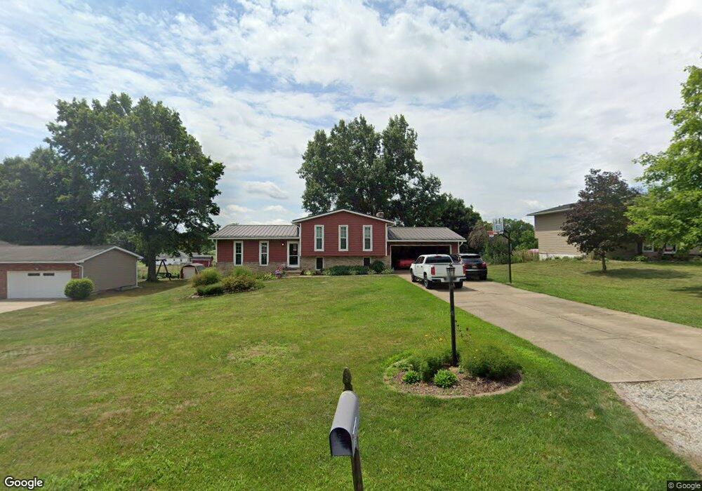
1600 Plateau St NE Uniontown, OH 44685
Estimated Value: $268,928 - $316,000
3
Beds
3
Baths
1,448
Sq Ft
$201/Sq Ft
Est. Value
About This Home
This home is located at 1600 Plateau St NE, Uniontown, OH 44685 and is currently estimated at $291,732, approximately $201 per square foot. 1600 Plateau St NE is a home located in Stark County with nearby schools including Lake Middle/High School and Lake Center Christian School.
Ownership History
Date
Name
Owned For
Owner Type
Purchase Details
Closed on
Sep 27, 1996
Sold by
Bell Michael F
Bought by
Mcsherry Scott A and Mcsherry Andrea
Current Estimated Value
Home Financials for this Owner
Home Financials are based on the most recent Mortgage that was taken out on this home.
Original Mortgage
$114,000
Outstanding Balance
$10,356
Interest Rate
7.97%
Mortgage Type
New Conventional
Estimated Equity
$281,376
Purchase Details
Closed on
Jun 17, 1992
Create a Home Valuation Report for This Property
The Home Valuation Report is an in-depth analysis detailing your home's value as well as a comparison with similar homes in the area
Home Values in the Area
Average Home Value in this Area
Purchase History
| Date | Buyer | Sale Price | Title Company |
|---|---|---|---|
| Mcsherry Scott A | $120,000 | -- | |
| -- | $80,000 | -- |
Source: Public Records
Mortgage History
| Date | Status | Borrower | Loan Amount |
|---|---|---|---|
| Open | Mcsherry Scott A | $114,000 |
Source: Public Records
Tax History Compared to Growth
Tax History
| Year | Tax Paid | Tax Assessment Tax Assessment Total Assessment is a certain percentage of the fair market value that is determined by local assessors to be the total taxable value of land and additions on the property. | Land | Improvement |
|---|---|---|---|---|
| 2025 | -- | $87,220 | $21,210 | $66,010 |
| 2024 | -- | $87,220 | $21,210 | $66,010 |
| 2023 | $3,304 | $70,810 | $13,230 | $57,580 |
| 2022 | $3,315 | $70,810 | $13,230 | $57,580 |
| 2021 | $3,353 | $70,810 | $13,230 | $57,580 |
| 2020 | $3,256 | $61,670 | $11,410 | $50,260 |
| 2019 | $3,226 | $61,670 | $11,410 | $50,260 |
| 2018 | $3,227 | $61,670 | $11,410 | $50,260 |
| 2017 | $2,993 | $53,130 | $11,410 | $41,720 |
| 2016 | $2,998 | $53,130 | $11,410 | $41,720 |
| 2015 | $2,996 | $53,130 | $11,410 | $41,720 |
| 2014 | $582 | $47,640 | $10,220 | $37,420 |
| 2013 | $1,291 | $47,640 | $10,220 | $37,420 |
Source: Public Records
Map
Nearby Homes
- 11121 Geib Ave NE
- 2084 Hazel St NE
- 1975 Eloise Cir NE
- 1037 Canyon St NE
- 1180 Tessa Trail Unit 1180
- 425 Tonawanda Trail SW
- 747 Grandview Cir
- 11900 Geib Ave NE
- 225 Seneca Trail SW
- 778 Fair Vista Cir SW
- 550 Woodlands Glen Ave
- 786 Fair Vista Cir SW
- 531 Gentlebrook Blvd SW
- 525 Gentlebrook Blvd SW
- 510 Meadow Cir SW Unit 11
- Unit 9 Meadow Trail SW Unit 9
- 9790 Smithdale Ave NE
- 9766 Smithdale Ave NE
- 330 Belle Ave SW
- 316 S Prospect Ave
- 1586 Plateau St NE
- 1624 Plateau St NE
- 1566 Plateau St NE
- 1648 Plateau St NE
- 1593 Plateau St NE
- 11017 Sagebrush Ave NE
- 1550 Plateau St NE
- 1663 Smith Kramer St NE
- 11025 Sagebrush Ave NE
- 1530 Plateau St NE
- 11056 Oasis Ave NE
- 11031 Sagebrush Ave NE
- 1667 Smith Kramer St NE
- 10988 Sagebrush Ave NE
- 11006 Sagebrush Ave NE
- 11018 Sagebrush Ave NE
- 11012 Sagebrush Ave NE
- 11035 Sagebrush Ave NE
- 1510 Plateau St NE
- 11015 Oasis Ave NE