Estimated Value: $410,000 - $560,000
3
Beds
2
Baths
1,899
Sq Ft
$248/Sq Ft
Est. Value
About This Home
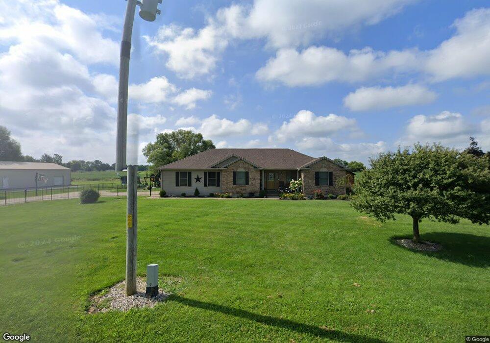
This home is located at 1600 Surface Rd, Eaton, OH 45320 and is currently estimated at $470,722, approximately $247 per square foot. 1600 Surface Rd is a home located in Preble County with nearby schools including Hollingsworth East Elementary School, William Bruce Elementary School, and Eaton Middle School.
Ownership History
Date
Name
Owned For
Owner Type
Purchase Details
Closed on
Nov 16, 2021
Sold by
Mccabe Luke and Mccabe Kristi R
Bought by
Dwyer Brian G and Dwyer Kelly S
Current Estimated Value
Home Financials for this Owner
Home Financials are based on the most recent Mortgage that was taken out on this home.
Original Mortgage
$407,550
Outstanding Balance
$373,449
Interest Rate
2.99%
Mortgage Type
New Conventional
Estimated Equity
$97,273
Purchase Details
Closed on
Jun 27, 2016
Sold by
Karen E Boomershine
Bought by
Mccabe Luke and Mccabe Kristi
Home Financials for this Owner
Home Financials are based on the most recent Mortgage that was taken out on this home.
Original Mortgage
$255,375
Interest Rate
3.56%
Purchase Details
Closed on
Sep 15, 2003
Sold by
Smith Jack H and Smith Dollene E
Bought by
Boomershine Thomas H and Boomershine Karen E
Create a Home Valuation Report for This Property
The Home Valuation Report is an in-depth analysis detailing your home's value as well as a comparison with similar homes in the area
Home Values in the Area
Average Home Value in this Area
Purchase History
| Date | Buyer | Sale Price | Title Company |
|---|---|---|---|
| Dwyer Brian G | -- | New Title Company Name | |
| Mccabe Luke | -- | -- | |
| Boomershine Thomas H | $22,500 | None Available |
Source: Public Records
Mortgage History
| Date | Status | Borrower | Loan Amount |
|---|---|---|---|
| Open | Dwyer Brian G | $407,550 | |
| Previous Owner | Mccabe Luke | $255,375 | |
| Previous Owner | Mccabe Luke | -- |
Source: Public Records
Tax History Compared to Growth
Tax History
| Year | Tax Paid | Tax Assessment Tax Assessment Total Assessment is a certain percentage of the fair market value that is determined by local assessors to be the total taxable value of land and additions on the property. | Land | Improvement |
|---|---|---|---|---|
| 2024 | $4,925 | $142,590 | $9,730 | $132,860 |
| 2023 | $4,925 | $142,590 | $9,730 | $132,860 |
| 2022 | $3,790 | $88,910 | $8,860 | $80,050 |
| 2021 | $3,980 | $88,910 | $8,860 | $80,050 |
| 2020 | $3,830 | $88,910 | $8,860 | $80,050 |
| 2019 | $3,393 | $78,190 | $7,630 | $70,560 |
| 2018 | $3,501 | $78,190 | $7,630 | $70,560 |
| 2017 | $3,499 | $78,190 | $7,630 | $70,560 |
| 2016 | $2,908 | $68,990 | $7,420 | $61,570 |
| 2014 | $2,946 | $70,140 | $7,420 | $62,720 |
| 2013 | $2,946 | $70,140 | $7,420 | $62,720 |
Source: Public Records
Map
Nearby Homes
- 3919 Spacht Rd
- 3571 N 127
- Us Rt 127
- 0 Washington Jackson Rd Unit 1516310
- 4141 Crawfordsville Campbellstown Rd
- 5283 W 35 Us
- 3127 Upshur Northern Rd
- 519 Romadoor Ave Unit 520
- 401 Romadoor Ave Unit 511 (BLDG 12)
- 4623 Crawfordsville Campbellstown Rd
- 3525 U S 127
- 236 Eaton Ave
- 217 Miller Ave
- 108 Martha Ct
- 109 Martha Ct
- 104 Martha Ct
- 105 Martha Ct
- 101 Martha Ct
- 125 Arlington Dr
- 105 Arlington Dr
- 1583 Surface Rd
- 1560 Surface Rd
- 1520 Surface Rd
- 1341 Surface Rd
- 1515 Surface Rd
- 1476 Surface Rd
- 1458 Surface Rd
- 1440 Surface Rd
- 1422 Surface Rd
- 1404 Surface Rd
- 1368 Surface Rd
- 1386 Surface Rd
- 1350 Surface Rd
- 1323 Surface Rd
- 1738 Surface Rd
- 1326 Surface Rd
- 1312 Surface Rd
- 0 Surface Rd
- 1891 Surface Rd
- 1302 Surface Rd