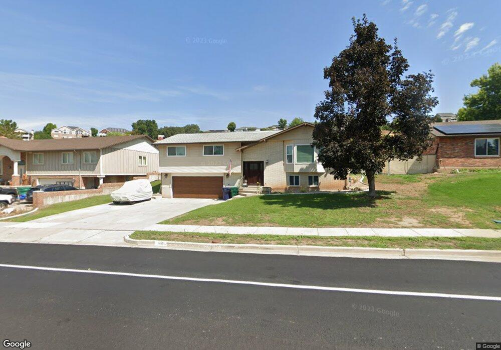
1601 Kays Creek Dr Layton, UT 84040
Estimated Value: $481,000 - $508,887
3
Beds
3
Baths
2,420
Sq Ft
$204/Sq Ft
Est. Value
About This Home
This home is located at 1601 Kays Creek Dr, Layton, UT 84040 and is currently estimated at $493,722, approximately $204 per square foot. 1601 Kays Creek Dr is a home located in Davis County with nearby schools including East Layton Elementary School, Central Davis Junior High School, and Northridge High School.
Ownership History
Date
Name
Owned For
Owner Type
Purchase Details
Closed on
Aug 21, 2019
Sold by
Trudel Emmett Anthony and The Emmett Anthony Trust
Bought by
Hedgepeth Fred K and Hedgepeth Colleen C
Current Estimated Value
Purchase Details
Closed on
Aug 18, 2016
Sold by
Christy Johnathan L
Bought by
Christy Johnathan L and Christy Shealynn
Create a Home Valuation Report for This Property
The Home Valuation Report is an in-depth analysis detailing your home's value as well as a comparison with similar homes in the area
Home Values in the Area
Average Home Value in this Area
Purchase History
| Date | Buyer | Sale Price | Title Company |
|---|---|---|---|
| Hedgepeth Fred K | -- | None Available | |
| Christy Johnathan L | -- | Vanguard Title | |
| Christy Johnathan L | -- | Inwest Title |
Source: Public Records
Tax History Compared to Growth
Tax History
| Year | Tax Paid | Tax Assessment Tax Assessment Total Assessment is a certain percentage of the fair market value that is determined by local assessors to be the total taxable value of land and additions on the property. | Land | Improvement |
|---|---|---|---|---|
| 2025 | $2,757 | $268,400 | $117,278 | $151,122 |
| 2024 | $2,631 | $259,600 | $142,306 | $117,294 |
| 2023 | $2,572 | $451,000 | $194,632 | $256,368 |
| 2022 | $2,712 | $260,150 | $104,156 | $155,994 |
| 2021 | $2,325 | $331,000 | $158,127 | $172,873 |
| 2020 | $2,105 | $287,000 | $126,503 | $160,497 |
| 2019 | $2,082 | $280,000 | $113,336 | $166,664 |
| 2018 | $1,874 | $253,000 | $87,047 | $165,953 |
| 2016 | $231 | $119,460 | $46,062 | $73,398 |
| 2015 | $1,616 | $108,955 | $46,062 | $62,893 |
| 2014 | $132 | $105,701 | $46,062 | $59,639 |
| 2013 | -- | $101,892 | $28,800 | $73,092 |
Source: Public Records
Map
Nearby Homes
- 1735 Hayes Dr
- 1463 Kays Creek Dr
- 1251 E Larkspur Way
- 1379 E Petunia Ct
- 1657 E Cherry Ln
- 2096 N 1450 E
- 2011 Dan Dr
- Richards Plan at Eastridge Park - The Vistas
- Brynlee Plan at Eastridge Park - The Vistas
- Brynlee Plan at Eastridge Park - The Heights
- Ontario Plan at Eastridge Park - The Heights
- Mclauren Plan at Eastridge Park - The Vistas
- Escher Plan at Eastridge Park - The Vistas
- Rivershore Plan at Eastridge Park - The Vistas
- Helene Plan at Eastridge Park - The Vistas
- Bromley Plan at Eastridge Park - The Heights
- Beringwood Plan at Eastridge Park - The Heights
- Caulfield Plan at Eastridge Park - The Heights
- Hawthorne Plan at Eastridge Park - The Heights
- Kimbrough Plan at Eastridge Park - The Vistas
- 1599 Kays Creek Dr
- 1615 Kays Creek Dr
- 1614 Kays Creek Dr
- 1790 Hayes Dr
- 1628 Kays Creek Dr
- 1593 Kays Creek Dr
- 1655 Kays Creek Dr
- 1581 Kays Creek Dr
- 1768 Hayes Dr
- 1795 Hayes Dr
- 1761 N 1700 E
- 1780 N 1700 E
- 1564 Kays Creek Dr
- 1668 Kays Creek Dr
- 1563 Kays Creek Dr
- 1777 Hayes Dr
- 1695 Kays Creek Dr
- 1762 N 1700 E
- 1829 N 1750 E
- 1764 Kays Creek Cir