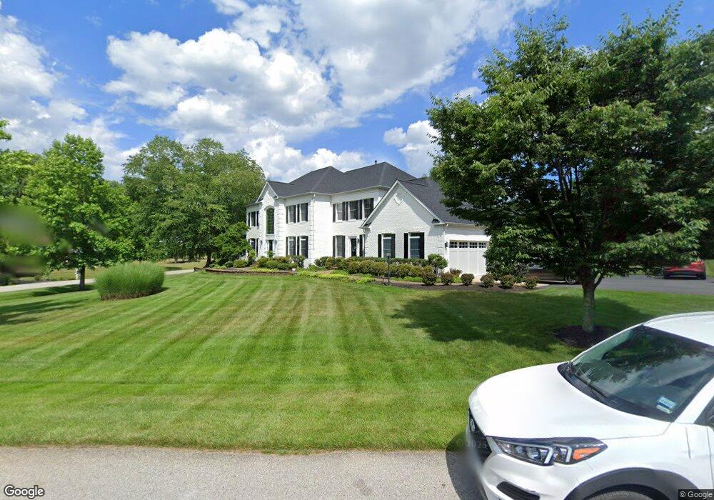
1601 Turks Cap Lily Ln Annapolis, MD 21401
Estimated Value: $1,349,642 - $1,572,000
5
Beds
5
Baths
5,010
Sq Ft
$293/Sq Ft
Est. Value
About This Home
This home is located at 1601 Turks Cap Lily Ln, Annapolis, MD 21401 and is currently estimated at $1,466,911, approximately $292 per square foot. 1601 Turks Cap Lily Ln is a home located in Anne Arundel County with nearby schools including South Shore Elementary School, Old Mill High School, and Indian Creek School.
Ownership History
Date
Name
Owned For
Owner Type
Purchase Details
Closed on
Dec 20, 2021
Sold by
Mge Ventures Llc
Bought by
Geismar Donald David and Geismar Abigail Ross
Current Estimated Value
Purchase Details
Closed on
Sep 30, 2009
Sold by
Koons Joseph R
Bought by
Mge Ventures Llc
Purchase Details
Closed on
Jul 16, 2004
Sold by
Loranger Keith G
Bought by
Koons Joseph R and Koons Kelly S
Purchase Details
Closed on
Jul 8, 2004
Sold by
Loranger Keith G
Bought by
Koons Joseph R and Koons Kelly S
Purchase Details
Closed on
Aug 4, 2003
Sold by
Washington Homes Inc
Bought by
Loranger Keith G
Create a Home Valuation Report for This Property
The Home Valuation Report is an in-depth analysis detailing your home's value as well as a comparison with similar homes in the area
Home Values in the Area
Average Home Value in this Area
Purchase History
| Date | Buyer | Sale Price | Title Company |
|---|---|---|---|
| Geismar Donald David | -- | None Available | |
| Mge Ventures Llc | $920,000 | -- | |
| Koons Joseph R | $1,273,600 | -- | |
| Koons Joseph R | $1,273,600 | -- | |
| Loranger Keith G | $1,020,000 | -- |
Source: Public Records
Mortgage History
| Date | Status | Borrower | Loan Amount |
|---|---|---|---|
| Closed | Koons Joseph R | -- |
Source: Public Records
Tax History Compared to Growth
Tax History
| Year | Tax Paid | Tax Assessment Tax Assessment Total Assessment is a certain percentage of the fair market value that is determined by local assessors to be the total taxable value of land and additions on the property. | Land | Improvement |
|---|---|---|---|---|
| 2025 | $11,217 | $1,066,567 | -- | -- |
| 2024 | $11,217 | $1,003,633 | $0 | $0 |
| 2023 | $10,900 | $940,700 | $215,600 | $725,100 |
| 2022 | $10,262 | $926,533 | $0 | $0 |
| 2021 | $10,114 | $912,367 | $0 | $0 |
| 2020 | $9,932 | $898,200 | $215,600 | $682,600 |
| 2019 | $9,941 | $898,200 | $215,600 | $682,600 |
| 2018 | $9,108 | $898,200 | $215,600 | $682,600 |
| 2017 | $10,625 | $1,013,600 | $0 | $0 |
| 2016 | -- | $983,167 | $0 | $0 |
| 2015 | -- | $952,733 | $0 | $0 |
| 2014 | -- | $922,300 | $0 | $0 |
Source: Public Records
Map
Nearby Homes
- 934 Chesterfield Rd
- 621 Wood Lot Trail Rd
- 0 Generals Hwy
- 1500 Cheltenham Ct E
- 1907 Mackiebeth Ct
- 1909 Eleanor Ct
- 1634 Old Generals Hwy
- 1496 River Rd
- 551 Defense Hwy
- 1603 Upton Scott Way
- 1101 Opaca Ct
- 1603 Huntcliff Way
- 1909 Marconi Cir
- 1809 Labrott Ln
- 1002 Covington Way
- 916 Sextant Way
- 2545 Lavall Ct
- 1007 Boom Ct
- 1404 Cotton Ct
- 1458 Wilderness Ridge Trail
- 1603 Turks Cap Lily Ln
- 1005 Queen Annes Lace Way
- 1004 Queen Annes Lace Way
- 1609 Turks Cap Lily Ln
- 1007 Queen Annes Lace Way
- 1600 Rabbit Foot Clover Ct
- 1665 Hawkins Rd
- 1611 Turks Cap Lily Ln
- 1604 Turks Cap Lily Ln
- 1602 Rabbit Foot Clover Ct
- 1009 Queen Annes Lace Way
- 1677 Hawkins Rd
- 1606 Turks Cap Lily Ln
- 1613 Turks Cap Lily Ln
- 1601 Rabbit Foot Clover Ct
- 1612 Turks Cap Lily Ln
- 1610 Turks Cap Lily Ln
- 1608 Turks Cap Lily Ln
- 1608 Turks Cap Lily Ln
- 1603 Rabbit Foot Clover Ct