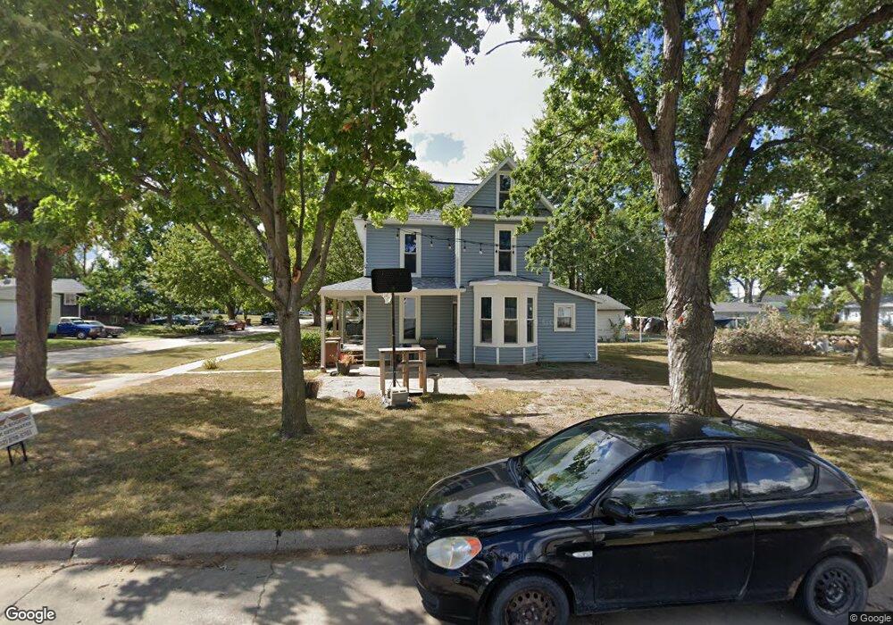
1602 Euclid St Ashland, NE 68003
Estimated Value: $181,000 - $210,000
4
Beds
1
Bath
1,342
Sq Ft
$147/Sq Ft
Est. Value
About This Home
This home is located at 1602 Euclid St, Ashland, NE 68003 and is currently estimated at $197,656, approximately $147 per square foot. 1602 Euclid St is a home located in Saunders County with nearby schools including Ashland-Greenwood Elementary School, Ashland-Greenwood Middle School, and Ashland-Greenwood High School.
Ownership History
Date
Name
Owned For
Owner Type
Purchase Details
Closed on
Apr 12, 2007
Sold by
Jp Morgan Chase Bank
Bought by
Pruitt Jr. Ted and Pruitt Melissa R
Current Estimated Value
Home Financials for this Owner
Home Financials are based on the most recent Mortgage that was taken out on this home.
Original Mortgage
$0
Interest Rate
6.13%
Purchase Details
Closed on
Oct 28, 2004
Sold by
Sanders James D and Sanders Judy L
Bought by
Laughlin Jerry E and Laughlin Teresa L
Home Financials for this Owner
Home Financials are based on the most recent Mortgage that was taken out on this home.
Original Mortgage
$70,000
Interest Rate
5.71%
Create a Home Valuation Report for This Property
The Home Valuation Report is an in-depth analysis detailing your home's value as well as a comparison with similar homes in the area
Home Values in the Area
Average Home Value in this Area
Purchase History
| Date | Buyer | Sale Price | Title Company |
|---|---|---|---|
| Pruitt Jr. Ted | -- | -- | |
| Laughlin Jerry E | -- | -- |
Source: Public Records
Mortgage History
| Date | Status | Borrower | Loan Amount |
|---|---|---|---|
| Open | Pruitt Jr. Ted | $26,500 | |
| Closed | Pruitt Jr. Ted | $0 | |
| Previous Owner | Laughlin Jerry E | $70,000 |
Source: Public Records
Tax History Compared to Growth
Tax History
| Year | Tax Paid | Tax Assessment Tax Assessment Total Assessment is a certain percentage of the fair market value that is determined by local assessors to be the total taxable value of land and additions on the property. | Land | Improvement |
|---|---|---|---|---|
| 2024 | $1,411 | $100,720 | $18,240 | $82,480 |
| 2023 | $1,773 | $102,870 | $18,240 | $84,630 |
| 2022 | $1,672 | $91,831 | $18,240 | $73,591 |
| 2021 | $1,758 | $97,488 | $18,240 | $79,248 |
| 2020 | $1,704 | $87,905 | $18,240 | $69,665 |
| 2019 | $1,771 | $87,905 | $18,240 | $69,665 |
| 2018 | $1,446 | $71,030 | $18,240 | $52,790 |
| 2017 | $1,509 | $71,420 | $18,240 | $53,180 |
| 2016 | $1,509 | $71,420 | $18,240 | $53,180 |
| 2015 | $1,546 | $71,420 | $18,240 | $53,180 |
| 2014 | $1,567 | $71,450 | $18,240 | $53,210 |
| 2012 | $1,673 | $71,450 | $18,240 | $53,210 |
Source: Public Records
Map
Nearby Homes
- 2204 N 22nd St
- 1006 N 22nd St
- 1010 N 22nd St
- 1008 N 22nd St
- 2202 N 22nd St
- 700 N 23rd St
- 800 N 23rd St
- 1010 N 23rd St
- 1011 N 23rd St
- 2205 N 22nd St
- 2203 Reagan Rd
- 2205 Reagan Rd
- 2207 Reagan Rd
- 2202 Reagan Rd
- 1010 N 24th St
- 1011 N 24th St
- 2204 Reagan Rd
- 2206 Reagan Rd
- 1011 Bluejay Cir
- 1013 Bluejay Cir