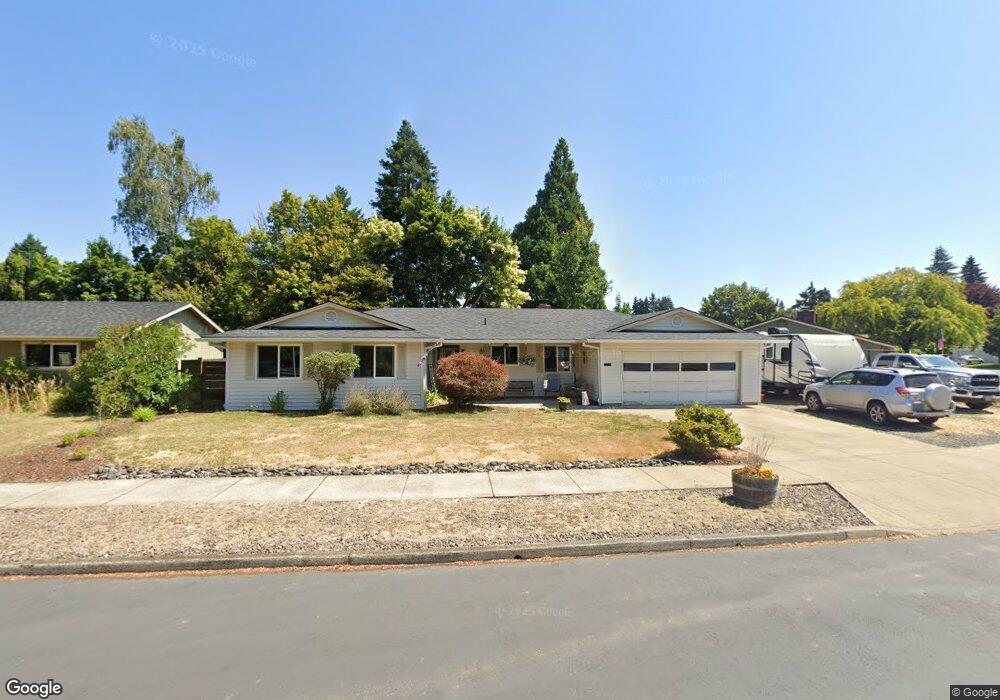
1603 Limpus Ln Forest Grove, OR 97116
Estimated Value: $517,000 - $527,000
3
Beds
2
Baths
1,515
Sq Ft
$344/Sq Ft
Est. Value
About This Home
This home is located at 1603 Limpus Ln, Forest Grove, OR 97116 and is currently estimated at $521,629, approximately $344 per square foot. 1603 Limpus Ln is a home located in Washington County with nearby schools including Harvey Clarke Elementary School, Tom McCall Upper Elementary School, and Neil Armstrong Middle School.
Ownership History
Date
Name
Owned For
Owner Type
Purchase Details
Closed on
Dec 15, 2016
Sold by
Boyd Steven F and Boyd Patricia L
Bought by
Boyd Steven Forrest and Boyd Patricia Lynne
Current Estimated Value
Purchase Details
Closed on
Apr 26, 2000
Sold by
Jackson Larry D and Jackson Kay E
Bought by
Boyd Steven F and Boyd Patricia
Home Financials for this Owner
Home Financials are based on the most recent Mortgage that was taken out on this home.
Original Mortgage
$119,960
Outstanding Balance
$40,509
Interest Rate
8.24%
Estimated Equity
$481,120
Create a Home Valuation Report for This Property
The Home Valuation Report is an in-depth analysis detailing your home's value as well as a comparison with similar homes in the area
Home Values in the Area
Average Home Value in this Area
Purchase History
| Date | Buyer | Sale Price | Title Company |
|---|---|---|---|
| Boyd Steven Forrest | -- | None Available | |
| Boyd Steven F | $149,950 | Transnation Title Insurance |
Source: Public Records
Mortgage History
| Date | Status | Borrower | Loan Amount |
|---|---|---|---|
| Open | Boyd Steven F | $119,960 |
Source: Public Records
Tax History Compared to Growth
Tax History
| Year | Tax Paid | Tax Assessment Tax Assessment Total Assessment is a certain percentage of the fair market value that is determined by local assessors to be the total taxable value of land and additions on the property. | Land | Improvement |
|---|---|---|---|---|
| 2026 | $4,714 | $264,730 | -- | -- |
| 2025 | $4,714 | $257,020 | -- | -- |
| 2024 | $4,548 | $249,540 | -- | -- |
| 2023 | $4,548 | $242,280 | $0 | $0 |
| 2022 | $3,977 | $242,280 | $0 | $0 |
| 2021 | $3,925 | $228,380 | $0 | $0 |
| 2020 | $3,904 | $221,730 | $0 | $0 |
| 2019 | $3,817 | $215,280 | $0 | $0 |
| 2018 | $3,700 | $209,010 | $0 | $0 |
| 2017 | $3,586 | $202,930 | $0 | $0 |
| 2016 | $3,485 | $197,020 | $0 | $0 |
| 2015 | $3,351 | $191,290 | $0 | $0 |
| 2014 | $3,335 | $185,720 | $0 | $0 |
Source: Public Records
Map
Nearby Homes
- 1425 Willamina Ave
- 1611 Camino Dr
- 1609 Camino Dr
- 1224 Alyssum Ave
- 1315 Begonia Ave
- 2327 Turnbull Ct
- 2341 Turnbull Ct
- 1104 Magnolia Way
- 1718 23rd Ave
- 2106 Charlie Ct
- 1222 Brookside Ave
- 3300 N Main St Unit 110
- 2517 Sweetwood Ct
- 922 Rosebud Ct
- 918 Rosebud Ct
- 2108 D St
- 1078 Vista Oaks Dr
- 2119 B St
- 1815 35th Ave
- 911 Rosebud Ct