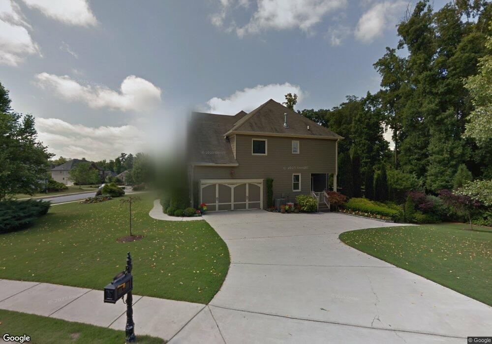
1604 Fort Mason Way Unit 3 Dacula, GA 30019
Estimated Value: $536,000 - $615,000
5
Beds
4
Baths
3,017
Sq Ft
$189/Sq Ft
Est. Value
About This Home
This home is located at 1604 Fort Mason Way Unit 3, Dacula, GA 30019 and is currently estimated at $570,692, approximately $189 per square foot. 1604 Fort Mason Way Unit 3 is a home located in Gwinnett County with nearby schools including Fort Daniel Elementary School, Frank N. Osborne Middle School, and Mill Creek High School.
Ownership History
Date
Name
Owned For
Owner Type
Purchase Details
Closed on
Jul 1, 2005
Sold by
David Orlofsky Inc
Bought by
Davies Betty A
Current Estimated Value
Home Financials for this Owner
Home Financials are based on the most recent Mortgage that was taken out on this home.
Original Mortgage
$265,000
Interest Rate
5.17%
Mortgage Type
New Conventional
Create a Home Valuation Report for This Property
The Home Valuation Report is an in-depth analysis detailing your home's value as well as a comparison with similar homes in the area
Home Values in the Area
Average Home Value in this Area
Purchase History
| Date | Buyer | Sale Price | Title Company |
|---|---|---|---|
| Davies Betty A | $332,000 | -- |
Source: Public Records
Mortgage History
| Date | Status | Borrower | Loan Amount |
|---|---|---|---|
| Closed | Davies Betty A | $265,000 |
Source: Public Records
Tax History Compared to Growth
Tax History
| Year | Tax Paid | Tax Assessment Tax Assessment Total Assessment is a certain percentage of the fair market value that is determined by local assessors to be the total taxable value of land and additions on the property. | Land | Improvement |
|---|---|---|---|---|
| 2025 | $6,722 | $235,640 | $44,000 | $191,640 |
| 2024 | $6,777 | $230,680 | $47,200 | $183,480 |
| 2023 | $6,777 | $219,280 | $47,200 | $172,080 |
| 2022 | $5,896 | $189,320 | $41,200 | $148,120 |
| 2021 | $4,971 | $140,960 | $29,400 | $111,560 |
| 2020 | $5,004 | $140,960 | $29,400 | $111,560 |
| 2019 | $4,838 | $140,960 | $29,400 | $111,560 |
| 2018 | $4,633 | $131,080 | $25,920 | $105,160 |
| 2016 | $4,213 | $115,760 | $21,600 | $94,160 |
| 2015 | $3,836 | $103,840 | $20,000 | $83,840 |
| 2014 | $3,757 | $101,040 | $20,000 | $81,040 |
Source: Public Records
Map
Nearby Homes
- 1603 Fort Perry Way
- 1827 Scouts Walk
- 2425 Fort Daniels Dr Unit 3A
- 2706 Captain Ct
- 2416 Moultrie Ct
- 1720 Fort Daniels Trail
- 1655 Brisbane Dr
- 2431 Lance Ridge Way
- 2765 Daniel Park Run Unit 3
- 1618 Rocky Knoll Ln
- 2687 High Creek Run
- 2674 Rocky Knoll Ct
- 2628 Adair Trail
- 2717 High Creek Run Unit 1
- 1521 Rocky Knoll Ln
- 2439 Canter Brook Ct Unit 1
- 2747 High Creek Run
- 1978 Mapmaker Dr
- 1958 Mapmaker Dr Unit 208
- 1958 Mapmaker Dr
- 1969 Mapmaker Dr
- 1625 Fort Mason Way Unit B
- 1988 Mapmaker Dr
- 1988 Mapmaker Dr Unit 3
- 1948 Mapmaker Dr
- 2502 Hidden Path Trace
- 1989 Mapmaker Dr Unit 3
- 1938 Mapmaker Dr Unit 3
- 1998 Mapmaker Dr Unit 212
- 1998 Mapmaker Dr Unit 3
- 1747 Fort River Way
- 1757 Fort River Way Unit 1757
- 1757 Fort River Way Unit xxx
- 1757 Fort River Way Unit 3B
- 1757 Fort River Way
- 2009 Mapmaker Dr
- 1737 Fort River Way