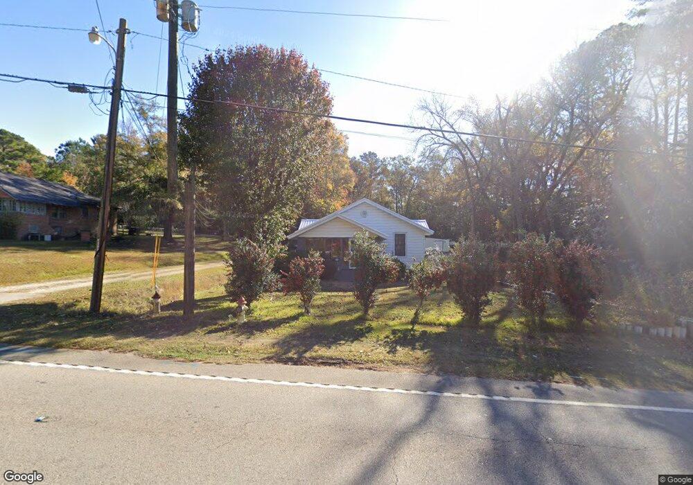
1604 Us Highway 29 West Point, GA 31833
Estimated Value: $142,000 - $179,000
3
Beds
2
Baths
1,418
Sq Ft
$113/Sq Ft
Est. Value
About This Home
This home is located at 1604 Us Highway 29, West Point, GA 31833 and is currently estimated at $160,635, approximately $113 per square foot. 1604 Us Highway 29 is a home located in Troup County with nearby schools including West Point Elementary School, Long Cane Elementary School, and Berta Weathersbee Elementary School.
Ownership History
Date
Name
Owned For
Owner Type
Purchase Details
Closed on
Nov 17, 1999
Sold by
J H and Hewitt Charlsie C
Bought by
Hewitt Charles Donald
Current Estimated Value
Purchase Details
Closed on
Dec 1, 1988
Bought by
J H and Hewitt Charlsie C
Purchase Details
Closed on
Jan 1, 1988
Purchase Details
Closed on
Jun 19, 1986
Purchase Details
Closed on
Jul 28, 1982
Purchase Details
Closed on
May 12, 1978
Purchase Details
Closed on
May 25, 1976
Purchase Details
Closed on
Jan 1, 1973
Create a Home Valuation Report for This Property
The Home Valuation Report is an in-depth analysis detailing your home's value as well as a comparison with similar homes in the area
Home Values in the Area
Average Home Value in this Area
Purchase History
| Date | Buyer | Sale Price | Title Company |
|---|---|---|---|
| Hewitt Charles Donald | -- | -- | |
| J H | -- | -- | |
| -- | -- | -- | |
| -- | $26,200 | -- | |
| -- | -- | -- | |
| -- | -- | -- | |
| -- | -- | -- | |
| -- | -- | -- |
Source: Public Records
Tax History Compared to Growth
Tax History
| Year | Tax Paid | Tax Assessment Tax Assessment Total Assessment is a certain percentage of the fair market value that is determined by local assessors to be the total taxable value of land and additions on the property. | Land | Improvement |
|---|---|---|---|---|
| 2024 | -- | $40,920 | $1,840 | $39,080 |
| 2023 | $0 | $40,864 | $1,840 | $39,024 |
| 2022 | $1,521 | $38,864 | $1,840 | $37,024 |
| 2021 | $855 | $21,840 | $1,840 | $20,000 |
| 2020 | $861 | $21,840 | $1,840 | $20,000 |
| 2019 | $728 | $18,464 | $1,864 | $16,600 |
| 2018 | $0 | $17,704 | $1,864 | $15,840 |
| 2017 | $0 | $17,704 | $1,864 | $15,840 |
| 2016 | $528 | $17,506 | $1,864 | $15,642 |
| 2015 | $529 | $17,506 | $1,864 | $15,642 |
| 2014 | $505 | $16,682 | $1,864 | $14,818 |
| 2013 | -- | $17,604 | $1,864 | $15,740 |
Source: Public Records
Map
Nearby Homes
- 1505 Wisteria Dr
- 508 Pine St
- 1903 Ridgewood Dr
- 0 Ga Highway 0116 Unit 10619139
- 1008 E 12th St
- 0 Sunset Dr Unit 10451831
- 106 Sunset Dr
- 0 Arrowhead Dr Unit 10451860
- 1410 Roper Ave
- 713 Avenue H
- 1314 4th Ave
- 804 E 6th St
- 509 Cleveland St
- 311 E 4th St
- 712 4th Ave
- 210 N 14th St
- 8035 County Road 289
- 112 Hillcrest Rd
- 514 N 8th Ave
- 404 Brookwood Dr
- 1606 Us Highway 29
- 1608 Us Highway 29
- 1603 Us Highway 29 Unit 284/5
- 1603 Us Highway 29 Unit 284/5
- 1603 Us Highway 29
- 1603 Us Highway 29
- 1603 Us Highway 29
- 1603 Us Highway 29
- 1603 Us Highway 29
- 1603 Us Highway 29
- 1603 Us Highway 29
- 1603 Us Highway 29
- 1603 Us Highway 29
- 1610 Us Highway 29
- 1609 Us Highway 29
- 1700 Malco Dr
- 406 Sheppard St
- 1702 Malco Dr
- 1704 Malco Dr
- 1600 Agate St