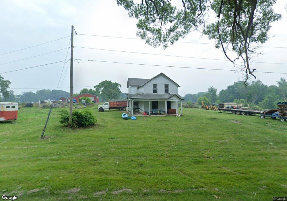
1605 High Bridge Rd Buchanan, MI 49107
Estimated Value: $298,000 - $408,000
3
Beds
1
Bath
2,024
Sq Ft
$169/Sq Ft
Est. Value
About This Home
This home is located at 1605 High Bridge Rd, Buchanan, MI 49107 and is currently estimated at $341,969, approximately $168 per square foot. 1605 High Bridge Rd is a home located in Berrien County with nearby schools including Ottawa Elementary School, Moccasin Elementary School, and Buchanan Middle School.
Ownership History
Date
Name
Owned For
Owner Type
Purchase Details
Closed on
Mar 15, 2023
Sold by
Pike Loy Dean
Bought by
German Mark Allen
Current Estimated Value
Home Financials for this Owner
Home Financials are based on the most recent Mortgage that was taken out on this home.
Original Mortgage
$168,000
Outstanding Balance
$162,688
Interest Rate
6.09%
Mortgage Type
New Conventional
Estimated Equity
$179,281
Purchase Details
Closed on
Feb 17, 2023
Sold by
Pike Loy Dean
Bought by
German Mark Allen
Home Financials for this Owner
Home Financials are based on the most recent Mortgage that was taken out on this home.
Original Mortgage
$168,000
Outstanding Balance
$162,688
Interest Rate
6.09%
Mortgage Type
New Conventional
Estimated Equity
$179,281
Purchase Details
Closed on
Jun 2, 1989
Purchase Details
Closed on
Oct 29, 1980
Create a Home Valuation Report for This Property
The Home Valuation Report is an in-depth analysis detailing your home's value as well as a comparison with similar homes in the area
Home Values in the Area
Average Home Value in this Area
Purchase History
| Date | Buyer | Sale Price | Title Company |
|---|---|---|---|
| German Mark Allen | $280,000 | -- | |
| German Mark Allen | $280,000 | None Listed On Document | |
| -- | $48,900 | -- | |
| -- | $32,000 | -- |
Source: Public Records
Mortgage History
| Date | Status | Borrower | Loan Amount |
|---|---|---|---|
| Open | German Mark Allen | $168,000 | |
| Closed | German Mark Allen | $168,000 |
Source: Public Records
Tax History Compared to Growth
Tax History
| Year | Tax Paid | Tax Assessment Tax Assessment Total Assessment is a certain percentage of the fair market value that is determined by local assessors to be the total taxable value of land and additions on the property. | Land | Improvement |
|---|---|---|---|---|
| 2025 | $2,991 | $136,900 | $0 | $0 |
| 2024 | $1,640 | $125,800 | $0 | $0 |
| 2023 | $1,084 | $111,100 | $0 | $0 |
| 2022 | $1,032 | $99,700 | $0 | $0 |
| 2021 | $1,875 | $98,500 | $48,500 | $50,000 |
| 2020 | $1,889 | $98,700 | $0 | $0 |
| 2019 | $1,817 | $87,900 | $45,000 | $42,900 |
| 2018 | $1,804 | $87,900 | $0 | $0 |
| 2017 | $1,785 | $88,900 | $0 | $0 |
| 2016 | $1,757 | $99,000 | $0 | $0 |
| 2015 | $1,755 | $92,100 | $0 | $0 |
| 2014 | $743 | $90,600 | $0 | $0 |
Source: Public Records
Map
Nearby Homes
- 5320 W US Highway 12
- 4630 W US Highway 12
- 5770 W US Highway 12
- 0 Us 12 W
- 4935 Curran Rd
- 16091 Roe St
- 2934 W Front St
- 15973 Walnut St
- 1936 E Clear Lake Rd
- 0 E Clear Lake Rd
- Track 4 W Us 12 Hwy Trail
- 15646 W Clear Lake Rd
- 000 W Clear Lake Rd
- 6460 E Galien Buchanan Rd
- 15657 Lakeview Dr
- 15326 Madron Lake Rd
- 2810 Oak Forest Rd
- 347 Georgetown Colony
- 704 Ottawa Ct
- 103 W Smith St
- 1635 High Bridge Rd
- 1575 High Bridge Rd
- 1575 High Bridge Rd
- 4995 W Us Highway 12
- 4995 U S 12
- 4965 U S 12
- 4965 W Us Highway 12
- 4955 U S 12
- 4955 W Us Highway 12
- 1680 High Bridge Rd
- 1560 High Bridge Rd
- 4990 W Us Highway 12
- 4945 U S 12
- 4945 W Us Highway 12
- 4945 W Us 12 Hwy
- 5040 W Us Highway 12
- 5040 W Us Highway 12
- 4970 W Us Highway 12
- 4925 W Us Highway 12
- 4980 W Us Highway 12