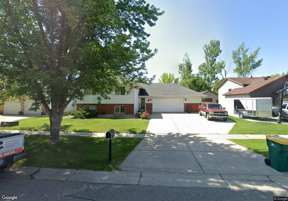
1605 Maple Place West Fargo, ND 58078
Tintes NeighborhoodEstimated Value: $334,000 - $343,000
4
Beds
2
Baths
2,102
Sq Ft
$161/Sq Ft
Est. Value
About This Home
This home is located at 1605 Maple Place, West Fargo, ND 58078 and is currently estimated at $338,623, approximately $161 per square foot. 1605 Maple Place is a home located in Cass County with nearby schools including Willow Park Elementary School, Cheney Middle School, and West Fargo High School.
Ownership History
Date
Name
Owned For
Owner Type
Purchase Details
Closed on
Nov 20, 2015
Sold by
Schrader Larry J and Schrader Judy A
Bought by
Kezar Eagleson Melissa
Current Estimated Value
Home Financials for this Owner
Home Financials are based on the most recent Mortgage that was taken out on this home.
Original Mortgage
$220,875
Outstanding Balance
$173,433
Interest Rate
3.74%
Mortgage Type
New Conventional
Estimated Equity
$165,190
Create a Home Valuation Report for This Property
The Home Valuation Report is an in-depth analysis detailing your home's value as well as a comparison with similar homes in the area
Home Values in the Area
Average Home Value in this Area
Purchase History
| Date | Buyer | Sale Price | Title Company |
|---|---|---|---|
| Kezar Eagleson Melissa | $237,500 | None Available |
Source: Public Records
Mortgage History
| Date | Status | Borrower | Loan Amount |
|---|---|---|---|
| Open | Kezar Eagleson Melissa | $220,875 |
Source: Public Records
Tax History
| Year | Tax Paid | Tax Assessment Tax Assessment Total Assessment is a certain percentage of the fair market value that is determined by local assessors to be the total taxable value of land and additions on the property. | Land | Improvement |
|---|---|---|---|---|
| 2024 | $3,581 | $143,200 | $29,800 | $113,400 |
| 2023 | $3,909 | $136,200 | $29,800 | $106,400 |
| 2022 | $3,821 | $128,150 | $29,800 | $98,350 |
| 2021 | $3,650 | $117,950 | $20,500 | $97,450 |
| 2020 | $3,502 | $116,550 | $20,500 | $96,050 |
| 2019 | $3,217 | $112,550 | $20,500 | $92,050 |
| 2018 | $3,116 | $112,700 | $20,500 | $92,200 |
| 2017 | $3,181 | $117,750 | $20,500 | $97,250 |
| 2016 | $2,837 | $114,950 | $20,500 | $94,450 |
| 2015 | $2,642 | $95,100 | $13,600 | $81,500 |
| 2014 | $2,597 | $88,900 | $13,600 | $75,300 |
| 2013 | $2,546 | $85,300 | $13,600 | $71,700 |
Source: Public Records
Map
Nearby Homes
- 1884 Huntington Ln
- 1829 13th St E
- 1842 52nd St S
- 1836 12th St E
- 1845 Huntington Ct
- 868 Lakeridge Place
- 1970 Burlington Dr
- 1409 Heatherwood Ct
- 783 14 1 2 Ave E
- 1511 11th Ave E
- 1423 10th Ave E Unit 206
- 724 Northridge Way
- 715 Northridge Way
- 921 Homestead Ct
- 722 14 1 2 Ave E
- 4836 9th Ave S
- 801 9th St E
- 1811 7th St E
- 1827 7th St E
- 4666 8th Ave S
- 1609 Maple Place
- 1601 Maple Place
- 1606 Ash Place
- 1613 Maple Place
- 1610 Ash Place
- 1602 Ash Place
- 1614 Ash Place
- 1606 Maple Place
- 1602 Maple Place
- 1619 Maple Place
- 1610 Maple Place
- 1519 Maple Ln
- 1614 Maple Place
- 1618 Ash Place
- 1612 16th St E
- 1621 Maple Place
- 1618 Maple Place
- 1518 Maple Ln
- 1614 16th St E
- 1622 Ash Place
Your Personal Tour Guide
Ask me questions while you tour the home.