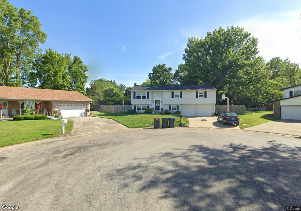
1605 Ridgewood Ct Mount Zion, IL 62549
Estimated Value: $173,000 - $203,000
--
Bed
--
Bath
1,292
Sq Ft
$144/Sq Ft
Est. Value
About This Home
This home is located at 1605 Ridgewood Ct, Mount Zion, IL 62549 and is currently estimated at $186,035, approximately $143 per square foot. 1605 Ridgewood Ct is a home located in Macon County with nearby schools including McGaughey Elementary School, Mt. Zion Intermediate School, and Mt. Zion Elementary School.
Ownership History
Date
Name
Owned For
Owner Type
Purchase Details
Closed on
Jun 16, 2017
Sold by
Watson James E and Watson Gina K
Bought by
Damery Caleb A and Damery Lindsey M
Current Estimated Value
Home Financials for this Owner
Home Financials are based on the most recent Mortgage that was taken out on this home.
Original Mortgage
$121,000
Outstanding Balance
$100,921
Interest Rate
4.12%
Mortgage Type
New Conventional
Estimated Equity
$85,114
Purchase Details
Closed on
Sep 1, 1994
Create a Home Valuation Report for This Property
The Home Valuation Report is an in-depth analysis detailing your home's value as well as a comparison with similar homes in the area
Home Values in the Area
Average Home Value in this Area
Purchase History
| Date | Buyer | Sale Price | Title Company |
|---|---|---|---|
| Damery Caleb A | -- | None Available | |
| -- | $88,000 | -- |
Source: Public Records
Mortgage History
| Date | Status | Borrower | Loan Amount |
|---|---|---|---|
| Open | Damery Caleb A | $121,000 |
Source: Public Records
Tax History Compared to Growth
Tax History
| Year | Tax Paid | Tax Assessment Tax Assessment Total Assessment is a certain percentage of the fair market value that is determined by local assessors to be the total taxable value of land and additions on the property. | Land | Improvement |
|---|---|---|---|---|
| 2024 | $4,076 | $58,222 | $7,261 | $50,961 |
| 2023 | $3,932 | $54,150 | $6,753 | $47,397 |
| 2022 | $3,754 | $51,361 | $6,405 | $44,956 |
| 2021 | $3,633 | $48,116 | $6,000 | $42,116 |
| 2020 | $2,924 | $40,294 | $5,009 | $35,285 |
| 2019 | $2,924 | $40,294 | $5,009 | $35,285 |
| 2018 | $2,830 | $39,265 | $4,881 | $34,384 |
| 2017 | $2,787 | $38,510 | $4,787 | $33,723 |
| 2016 | $2,755 | $37,840 | $4,704 | $33,136 |
| 2015 | $2,662 | $37,465 | $4,657 | $32,808 |
| 2014 | $2,567 | $37,465 | $4,657 | $32,808 |
| 2013 | $2,596 | $37,465 | $4,657 | $32,808 |
Source: Public Records
Map
Nearby Homes
- 570 Fawn Ct
- 860 W Wildwood Dr
- 925 S Wildwood Dr
- 1440 N Alexander Dr
- 1610 Robin Ct
- 24 Buttonridge Place
- 5301 Ricky Dr
- 125 W Walnut St
- 820 Kirk Dr
- 3330 S Baltimore Ave
- 2125 Buckhead Ave
- 1820 Buckhead Ln
- 2130 Buckhead Ave
- 400 Maddox Dr
- 2110 Buckhead Ln
- 2020 Buckhead Ln
- 1935 Buckhead Ct
- 2030 Buckhead Ln
- 402 Rolling Green Dr
- 265 Carrington Ave
- 1615 Ridgewood Ct
- 614 N Antler Dr
- 1600 Ridgewood Ct
- 634 N Antler Dr
- 1610 Sherwood Ct
- 604 N Antler Dr
- 1600 Sherwood Ct
- 1610 Ridgewood Ct
- 1625 Ridgewood Ct
- 644 N Antler Dr
- 584 N Antler Dr
- 1620 Sherwood Ct
- 1620 Ridgewood Ct
- 654 N Antler Dr
- 654 N Antler Dr Unit Antler
- 1605 Woodland Dr
- 623 N Antler Dr
- 633 N Antler Dr
- 535 W Wildwood Dr
- 1615 Woodland Dr