Estimated Value: $176,000 - $203,779
Studio
2
Baths
1,336
Sq Ft
$146/Sq Ft
Est. Value
About This Home
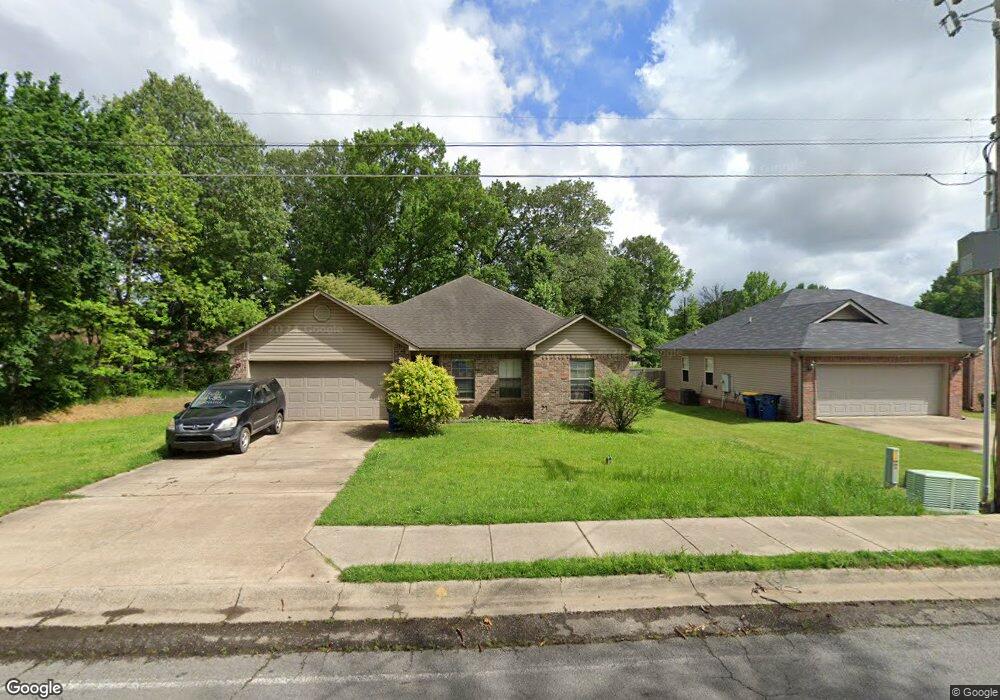
This home is located at 1605 S 1st St, Cabot, AR 72023 and is currently estimated at $195,195, approximately $146 per square foot. 1605 S 1st St is a home located in Lonoke County with nearby schools including Westside Elementary School, Cabot Junior High South, and Cabot Middle School South.
Ownership History
Date
Name
Owned For
Owner Type
Purchase Details
Closed on
Oct 3, 2023
Sold by
Miller & Abshure Construction Llc
Bought by
Miller & Abshure Construction Llc
Current Estimated Value
Purchase Details
Closed on
Jun 20, 2006
Bought by
Miller and Abshure Const
Purchase Details
Closed on
Jan 11, 2006
Bought by
Pcii and 820
Purchase Details
Closed on
Dec 29, 2005
Bought by
Plat Pc2-817
Create a Home Valuation Report for This Property
The Home Valuation Report is an in-depth analysis detailing your home's value as well as a comparison with similar homes in the area
Purchase History
| Date | Buyer | Sale Price | Title Company |
|---|---|---|---|
| Miller & Abshure Construction Llc | -- | None Listed On Document | |
| Miller | $25,000 | -- | |
| Pcii | -- | -- | |
| Plat Pc2-817 | -- | -- |
Source: Public Records
Tax History
| Year | Tax Paid | Tax Assessment Tax Assessment Total Assessment is a certain percentage of the fair market value that is determined by local assessors to be the total taxable value of land and additions on the property. | Land | Improvement |
|---|---|---|---|---|
| 2025 | $1,331 | $26,140 | $5,000 | $21,140 |
| 2024 | $1,331 | $26,140 | $5,000 | $21,140 |
| 2023 | $1,331 | $26,140 | $5,000 | $21,140 |
| 2022 | $1,331 | $26,140 | $5,000 | $21,140 |
| 2021 | $1,331 | $26,140 | $5,000 | $21,140 |
| 2020 | $1,225 | $24,060 | $5,000 | $19,060 |
| 2019 | $1,225 | $24,060 | $5,000 | $19,060 |
| 2018 | $1,189 | $24,060 | $5,000 | $19,060 |
| 2017 | $1,104 | $24,060 | $5,000 | $19,060 |
| 2016 | $1,189 | $24,060 | $5,000 | $19,060 |
| 2015 | $1,143 | $24,900 | $5,000 | $19,900 |
| 2014 | $1,230 | $24,900 | $5,000 | $19,900 |
Source: Public Records
Map
Nearby Homes
- 28 Pheasant Run Dr
- 20 Paige Ave
- 30 Mcarthur Dr
- 2213 S 2nd St
- 19 Trinity Dr
- 92 Sycamore Cir
- 37 Saint John St
- 921 Villa Vista Loop
- 49 Oak Meadows Dr
- 51 Nevada Ln
- 15513 & 15517 Ar Hwy 5
- 10 Brixton
- 12 Bellaire Dr
- 39 Nevada Ln
- 914 W Dell Vista Cove
- 912 W Dell Vista Cove
- 911 W Dell Vista Cove
- 20 Albion Ct
- 35 Nevada Ln
- 115 Rodney Guthrie Dr
- 12 Pheasant Run Dr
- 14 Pheasant Run Dr
- 10 Pheasant Run Dr
- 16 Pheasant Run Dr
- 1602 S 1st St
- 1608 S 1st St
- 1609 S 1st St
- 18 Pheasant Run Dr
- 1610 S 1st St
- 17 Pheasant Run Dr
- 1611 S 1st St
- 15 Pheasant Run Dr
- 21 Pheasant Run Dr
- 20 Pheasant Run Dr
- 106 Lee St Unit 108
- 13 Pheasant Run Dr
- 22 Pheasant Run Dr
- 11 Pheasant Run Dr
- 1500 S 1st St
- 16 Allison Dr
Your Personal Tour Guide
Ask me questions while you tour the home.