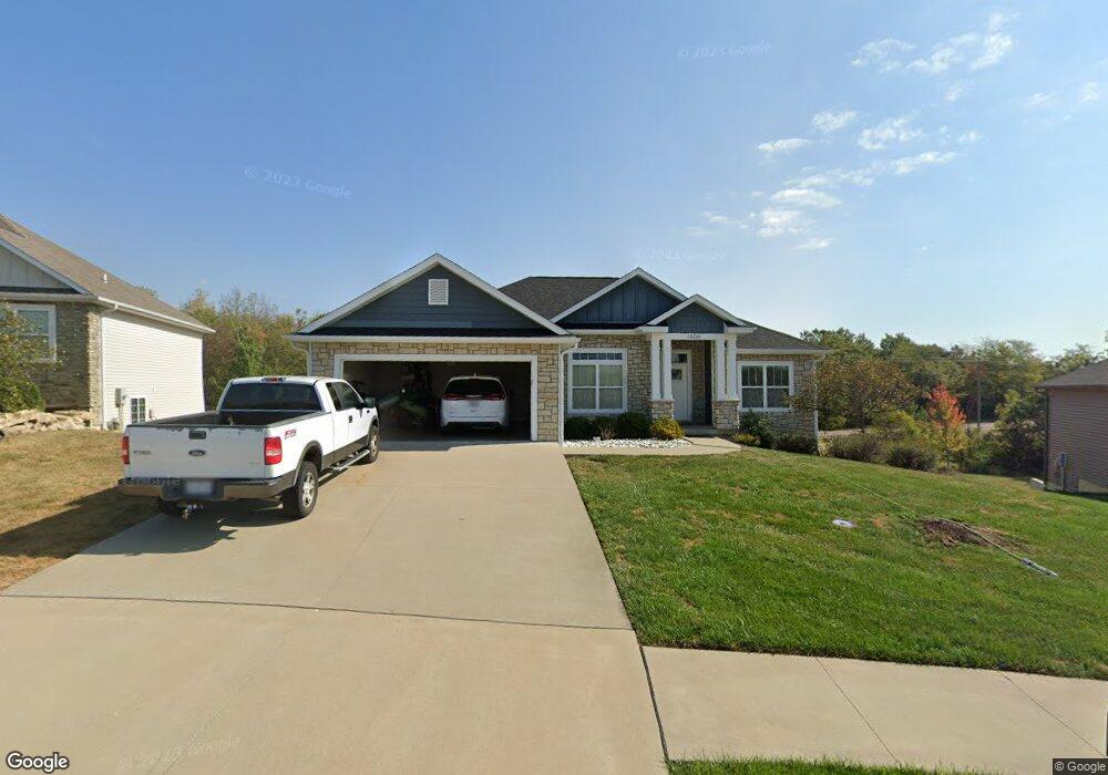
1606 Andretti Cir Columbia, MO 65201
Estimated Value: $389,000 - $410,906
3
Beds
2
Baths
1,901
Sq Ft
$210/Sq Ft
Est. Value
About This Home
This home is located at 1606 Andretti Cir, Columbia, MO 65201 and is currently estimated at $398,977, approximately $209 per square foot. 1606 Andretti Cir is a home with nearby schools including Cedar Ridge Elementary School, Oakland Middle School, and Muriel W. Battle High School.
Ownership History
Date
Name
Owned For
Owner Type
Purchase Details
Closed on
May 15, 2014
Sold by
Spillman Contracting Llc
Bought by
Woodward Josh and Woodward Melanie
Current Estimated Value
Home Financials for this Owner
Home Financials are based on the most recent Mortgage that was taken out on this home.
Original Mortgage
$195,500
Outstanding Balance
$149,715
Interest Rate
4.46%
Mortgage Type
New Conventional
Estimated Equity
$249,262
Purchase Details
Closed on
Dec 18, 2013
Sold by
Boone Landholdings Llc
Bought by
Spillman Contracting Llc
Create a Home Valuation Report for This Property
The Home Valuation Report is an in-depth analysis detailing your home's value as well as a comparison with similar homes in the area
Home Values in the Area
Average Home Value in this Area
Purchase History
| Date | Buyer | Sale Price | Title Company |
|---|---|---|---|
| Woodward Josh | -- | Boone Central Title Co | |
| Spillman Contracting Llc | -- | Boone Central Title Company |
Source: Public Records
Mortgage History
| Date | Status | Borrower | Loan Amount |
|---|---|---|---|
| Open | Woodward Josh | $195,500 |
Source: Public Records
Tax History Compared to Growth
Tax History
| Year | Tax Paid | Tax Assessment Tax Assessment Total Assessment is a certain percentage of the fair market value that is determined by local assessors to be the total taxable value of land and additions on the property. | Land | Improvement |
|---|---|---|---|---|
| 2025 | $3,187 | $54,074 | $9,386 | $44,688 |
| 2024 | $3,187 | $47,234 | $9,386 | $37,848 |
| 2023 | $3,160 | $47,234 | $9,386 | $37,848 |
| 2022 | $3,035 | $45,410 | $9,386 | $36,024 |
| 2021 | $3,041 | $45,410 | $9,386 | $36,024 |
| 2020 | $3,236 | $45,410 | $9,386 | $36,024 |
| 2019 | $3,236 | $45,410 | $9,386 | $36,024 |
| 2018 | $3,259 | $0 | $0 | $0 |
| 2017 | $3,214 | $45,410 | $9,386 | $36,024 |
| 2016 | $3,214 | $45,410 | $9,386 | $36,024 |
| 2015 | $2,951 | $45,410 | $9,386 | $36,024 |
| 2014 | $337 | $5,168 | $5,168 | $0 |
Source: Public Records
Map
Nearby Homes
- 5004 Stone Mountain Pkwy
- 4910 Stone Mountain Pkwy
- 4903 Stone Mountain Pkwy
- 5012 Kenora Dr
- 2001 Stone Mountain Pkwy
- 1108 Shore Acres Loop
- 5402 Wild Horse Ct
- 1459 Spring Mountain Dr
- 1050 Shore Acres Loop
- 1303 Morning Dove Dr
- 1301 Morning Dove Dr
- 4917 Longbow Dr
- 4720 Kenora Dr
- 1108 Shadow Hawk Ct
- 1620 S Berkley Dr
- 1104 Shadow Hawk Ct
- 1644 Spring Mountain Dr
- 2109 August Briggs Dr
- 4801 Hoylake Cir
- 4805 Hoylake Cir
- 1604 Andretti Cir
- 1608 Andretti Cir
- 1602 Andretti Cir
- 1610 Andretti Cir
- 1607 Andretti Cir
- 1609 Andretti Cir
- 1700 Andretti Cir
- 1407 S Cedar Grove Blvd
- 1605 Andretti Cir
- 1603 Andretti Cir
- 1702 Andretti Cir
- 1701 Andretti Cir
- 1409 S Cedar Grove Blvd
- 5009 Stone Mountain Pkwy
- 5005 Andretti Cir
- 5003 Stone Mountain Pkwy
- 1602 Ballentine Ln
- 1600 Ballentine Ln
- 1604 Ballentine Ln
- 1606 Ballentine Ln