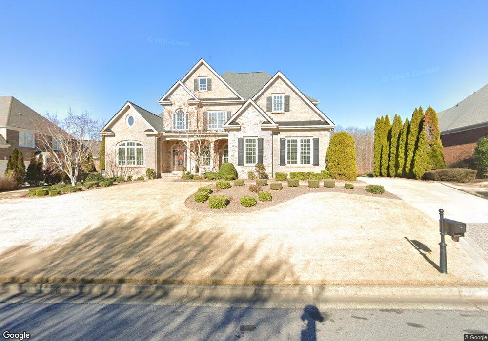
1606 Heathrow Dr Cumming, GA 30041
Estimated Value: $1,089,537 - $1,336,000
4
Beds
5
Baths
4,153
Sq Ft
$285/Sq Ft
Est. Value
About This Home
This home is located at 1606 Heathrow Dr, Cumming, GA 30041 and is currently estimated at $1,183,134, approximately $284 per square foot. 1606 Heathrow Dr is a home located in Forsyth County with nearby schools including Haw Creek Elementary School, Lakeside Middle School, and South Forsyth High School.
Ownership History
Date
Name
Owned For
Owner Type
Purchase Details
Closed on
Feb 5, 2011
Sold by
Fohs Terrence E
Bought by
Fohs Sandy R
Current Estimated Value
Home Financials for this Owner
Home Financials are based on the most recent Mortgage that was taken out on this home.
Original Mortgage
$150,000
Outstanding Balance
$102,544
Interest Rate
4.76%
Mortgage Type
New Conventional
Estimated Equity
$1,080,590
Purchase Details
Closed on
May 26, 2005
Sold by
Osley Builders Inc
Bought by
Fohs Terrence E and Fohs Sandy
Create a Home Valuation Report for This Property
The Home Valuation Report is an in-depth analysis detailing your home's value as well as a comparison with similar homes in the area
Home Values in the Area
Average Home Value in this Area
Purchase History
| Date | Buyer | Sale Price | Title Company |
|---|---|---|---|
| Fohs Sandy R | -- | -- | |
| Fohs Terrence E | $729,300 | -- |
Source: Public Records
Mortgage History
| Date | Status | Borrower | Loan Amount |
|---|---|---|---|
| Open | Fohs Sandy R | $150,000 |
Source: Public Records
Tax History Compared to Growth
Tax History
| Year | Tax Paid | Tax Assessment Tax Assessment Total Assessment is a certain percentage of the fair market value that is determined by local assessors to be the total taxable value of land and additions on the property. | Land | Improvement |
|---|---|---|---|---|
| 2025 | $1,723 | $440,836 | $84,000 | $356,836 |
| 2024 | $1,723 | $390,464 | $76,000 | $314,464 |
| 2023 | $1,657 | $388,000 | $66,000 | $322,000 |
| 2022 | $1,682 | $244,956 | $36,000 | $208,956 |
| 2021 | $1,649 | $244,956 | $36,000 | $208,956 |
| 2020 | $1,640 | $235,780 | $36,000 | $199,780 |
| 2019 | $1,646 | $231,884 | $36,000 | $195,884 |
| 2018 | $1,660 | $235,464 | $36,000 | $199,464 |
| 2017 | $1,661 | $219,540 | $36,000 | $183,540 |
| 2016 | $1,661 | $219,540 | $36,000 | $183,540 |
| 2015 | $1,661 | $219,540 | $36,000 | $183,540 |
| 2014 | $1,504 | $203,528 | $0 | $0 |
Source: Public Records
Map
Nearby Homes
- 1041 Windermere Crossing
- 1037 Windermere Crossing
- 3245 Sparling St
- 1415 Elgin Way
- 3780 Stanford Dr
- 3320 Spencer St
- 3330 Spencer St
- 1458 Edenfield Pte
- 1458 Edenfield Pointe
- 3055 Saint Gallen Ct
- 3340 Silver Lake Dr
- 2860 Chamonix Dr
- 3000 Chamonix Dr
- 3990 Sweeting St
- 3138 Neal Ct
- 3105 Neal Ct
- 3500 Alexander Cir
- 5613 Lancashire Ln
- 2540 Marsha Cir
- 2510 Benefield Rd
- 1608 Heathrow Dr
- 1604 Heathrow Dr
- 1610 Heathrow Dr
- 1605 Heathrow Dr
- 1602 Heathrow Dr
- 1607 Heathrow Dr
- 1603 Heathrow Dr
- 1609 Heathrow Dr
- 1612 Heathrow Dr
- 1601 Heathrow Dr
- 1600 Heathrow Dr
- 1611 Heathrow Dr
- 1804 Fenton Manor
- 1614 Heathrow Dr
- 1014 Windermere Crossing
- 1008 Windermere Crossing
- 1802 Fenton Manor
- 1613 Heathrow Dr
- 1016 Windermere Crossing
- 1806 Fenton Manor