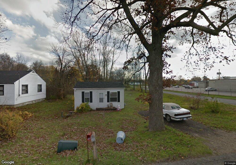
1606 Territorial Rd Benton Harbor, MI 49022
Benton Heights NeighborhoodEstimated Value: $43,000 - $99,000
--
Bed
--
Bath
764
Sq Ft
$95/Sq Ft
Est. Value
About This Home
This home is located at 1606 Territorial Rd, Benton Harbor, MI 49022 and is currently estimated at $72,614, approximately $95 per square foot. 1606 Territorial Rd is a home located in Berrien County with nearby schools including Fair Plain Middle School, Benton Harbor High School, and Mildred C. Wells Preparatory Academy.
Ownership History
Date
Name
Owned For
Owner Type
Purchase Details
Closed on
Jun 17, 2024
Sold by
Alexander Devin
Bought by
Berrien County Treasurer
Current Estimated Value
Purchase Details
Closed on
Jun 13, 2023
Sold by
Alexander Devin
Bought by
Berrien County Treasurer
Purchase Details
Closed on
Jun 28, 2022
Sold by
Richmond Willis R
Bought by
Alexander Devin L
Purchase Details
Closed on
Jun 27, 2022
Sold by
Richmond Willis R
Bought by
Richmond Willis R
Purchase Details
Closed on
Sep 19, 2002
Sold by
Buchanan Georgia
Bought by
Buchanan Georgia and Richmond Georgia
Create a Home Valuation Report for This Property
The Home Valuation Report is an in-depth analysis detailing your home's value as well as a comparison with similar homes in the area
Home Values in the Area
Average Home Value in this Area
Purchase History
| Date | Buyer | Sale Price | Title Company |
|---|---|---|---|
| Berrien County Treasurer | -- | -- | |
| Berrien County Treasurer | -- | -- | |
| Alexander Devin L | -- | Miller Johnson Schroeder Plc | |
| Richmond Willis R | -- | Miller Johnson Schroeder Plc | |
| Buchanan Georgia | -- | -- | |
| -- | -- | -- |
Source: Public Records
Tax History Compared to Growth
Tax History
| Year | Tax Paid | Tax Assessment Tax Assessment Total Assessment is a certain percentage of the fair market value that is determined by local assessors to be the total taxable value of land and additions on the property. | Land | Improvement |
|---|---|---|---|---|
| 2025 | $1,850 | $23,500 | $0 | $0 |
| 2024 | $698 | $19,700 | $0 | $0 |
| 2023 | $665 | $18,600 | $0 | $0 |
| 2022 | $193 | $14,300 | $0 | $0 |
| 2021 | $313 | $13,800 | $1,700 | $12,100 |
| 2020 | $310 | $13,500 | $0 | $0 |
| 2019 | $843 | $9,900 | $1,100 | $8,800 |
| 2018 | $325 | $9,900 | $0 | $0 |
| 2017 | $321 | $9,200 | $0 | $0 |
| 2016 | $317 | $9,100 | $0 | $0 |
| 2015 | $314 | $9,000 | $0 | $0 |
| 2014 | $166 | $9,000 | $0 | $0 |
Source: Public Records
Map
Nearby Homes
- 185 Felton St
- 149 Bridgman Ave
- 140 N Crystal Ave
- 394 Linden St
- 1226 Chicago Ave
- 425 N Euclid Ave
- 234 Walnut St
- 2202 Berg Ave
- 1069 E Main St
- 000 N Euclid Ave
- 00 N Euclid Ave
- 0 N Euclid Ave Unit 24029856
- 948 Baldanza Ave
- 1993 Taube Ave
- 2039 Taube Ave
- 238 Pine St
- 2062 Hatch Ave
- 992 Highland Ave
- 137 Cornelia St
- 6525 Territorial Rd
- 1616 Territorial Rd
- 1626 Territorial Rd
- 1636 Territorial Rd
- 1591 Territorial Rd
- 1635 Territorial Rd
- 465 Bridgman Ave
- 532 Midway Dr
- 1645 Territorial Rd
- 540 Midway Dr
- 543 Bridgman Ave
- 1656 Territorial Rd
- 527 Midway Dr
- 542 Bridgman Ave
- 1655 Territorial Rd
- 551 Bridgman Ave
- 450 N Crystal Ave
- 556 Midway Dr
- 533 Midway Dr
- 451 Bridgman Ave
- 1695 Territorial Rd