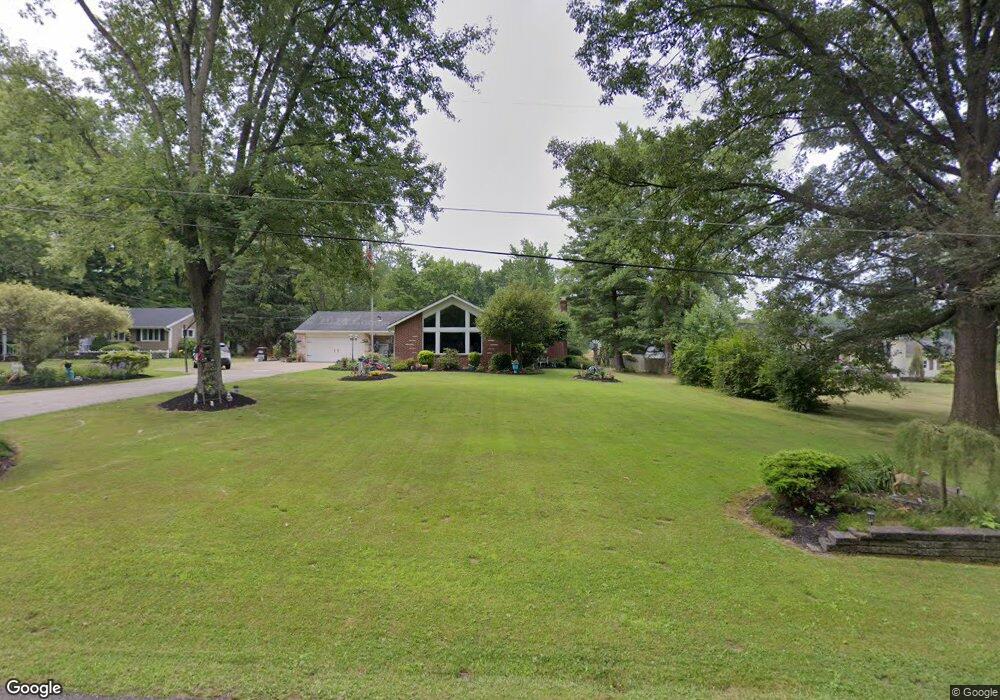
16080 Cenfield St NE Alliance, OH 44601
Estimated Value: $155,000 - $266,000
3
Beds
1
Bath
948
Sq Ft
$211/Sq Ft
Est. Value
About This Home
This home is located at 16080 Cenfield St NE, Alliance, OH 44601 and is currently estimated at $200,271, approximately $211 per square foot. 16080 Cenfield St NE is a home located in Stark County with nearby schools including Marlington High School and New Franklin Christian Academy.
Ownership History
Date
Name
Owned For
Owner Type
Purchase Details
Closed on
Apr 5, 2024
Sold by
Shonk Bruce C
Bought by
Shonk Bruce C and Shonk Rhonda
Current Estimated Value
Purchase Details
Closed on
May 14, 2003
Sold by
Omealy Dorothy E
Bought by
Shonk Janice C
Home Financials for this Owner
Home Financials are based on the most recent Mortgage that was taken out on this home.
Original Mortgage
$100,300
Interest Rate
5.87%
Create a Home Valuation Report for This Property
The Home Valuation Report is an in-depth analysis detailing your home's value as well as a comparison with similar homes in the area
Home Values in the Area
Average Home Value in this Area
Purchase History
| Date | Buyer | Sale Price | Title Company |
|---|---|---|---|
| Shonk Bruce C | -- | None Listed On Document | |
| Shonk Bruce C | $67,400 | None Listed On Document | |
| Shonk Janice C | $118,000 | -- |
Source: Public Records
Mortgage History
| Date | Status | Borrower | Loan Amount |
|---|---|---|---|
| Previous Owner | Shonk Janice C | $100,300 |
Source: Public Records
Tax History Compared to Growth
Tax History
| Year | Tax Paid | Tax Assessment Tax Assessment Total Assessment is a certain percentage of the fair market value that is determined by local assessors to be the total taxable value of land and additions on the property. | Land | Improvement |
|---|---|---|---|---|
| 2025 | -- | $37,140 | $11,590 | $25,550 |
| 2024 | $611 | $37,140 | $11,590 | $25,550 |
| 2023 | $1,167 | $34,790 | $8,050 | $26,740 |
| 2022 | $1,115 | $34,790 | $8,050 | $26,740 |
| 2021 | $1,119 | $34,790 | $8,050 | $26,740 |
| 2020 | $1,102 | $30,700 | $6,930 | $23,770 |
| 2019 | $1,094 | $30,700 | $6,930 | $23,770 |
| 2018 | $1,096 | $30,700 | $6,930 | $23,770 |
| 2017 | $999 | $25,980 | $6,790 | $19,190 |
| 2016 | $980 | $25,980 | $6,790 | $19,190 |
| 2015 | $981 | $25,980 | $6,790 | $19,190 |
| 2014 | $1,000 | $24,190 | $6,340 | $17,850 |
| 2013 | $501 | $24,190 | $6,340 | $17,850 |
Source: Public Records
Map
Nearby Homes
- 16159 Salem Church St NE
- 6378 Union Ave NE
- 6434 Union Ave NE
- 22120 Center Rd
- 5200 Union Ave NE
- 540 E Bayton St
- 1299 E Bayton St
- 1100 E Bayton St
- 1835 Homeworth Rd
- 22840 Buck Rd
- 3709 S Union Ave
- 3636 S Mahoning Ave
- 5869 Beechwood Ave
- 256 Laramie St
- 277 W Carol St
- 13881 Salem Church St NE
- 22360 Margaret Ln
- 1105 Abbey Ln
- 3101 Ridgehill Ave
- 1325 W Beech St
- 16060 Cenfield St NE
- 16036 Cenfield St NE
- 16010 Cenfield St NE
- 15981 Cenfield St NE
- 16119 Cenfield St NE
- 16146 Cenfield St NE
- 15970 Cenfield St NE
- 15934 Cenfield St NE
- 15910 Cenfield St NE
- 16230 Cenfield St NE
- 16205 Cenfield St NE
- 15894 Cenfield St NE
- 15865 Cenfield St NE
- 16285 Cenfield St NE
- 15836 Cenfield St NE
- 16227 Cenfield St NE
- 15811 Cenfield St NE
- 16339 Cenfield St NE
- 15950 Cenfield St NE
- 15794 Cenfield St NE