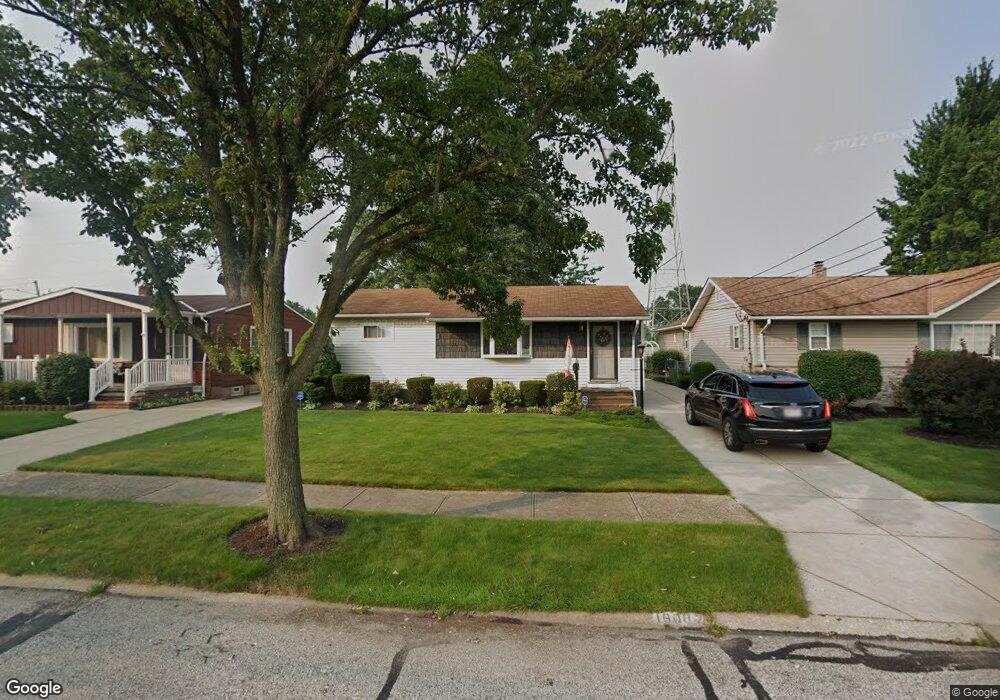
16087 Paulding Blvd Brookpark, OH 44142
Estimated Value: $202,831 - $234,000
3
Beds
1
Bath
912
Sq Ft
$242/Sq Ft
Est. Value
About This Home
This home is located at 16087 Paulding Blvd, Brookpark, OH 44142 and is currently estimated at $220,708, approximately $242 per square foot. 16087 Paulding Blvd is a home located in Cuyahoga County with nearby schools including Berea-Midpark Middle School, Berea-Midpark High School, and Huber Heights Preparatory Academy Parma Academy.
Ownership History
Date
Name
Owned For
Owner Type
Purchase Details
Closed on
Mar 1, 2024
Sold by
Korkan Douglas and Korkan Barbara A
Bought by
Karn David J
Current Estimated Value
Purchase Details
Closed on
Feb 5, 1993
Sold by
Priesand Barbara
Bought by
Priesand Barbara
Purchase Details
Closed on
Jan 28, 1993
Sold by
Urbansky Robert J
Bought by
Priesand Barbara
Purchase Details
Closed on
Jun 5, 1987
Sold by
Saunders David and Saunders C
Bought by
Urbansky Robert J
Purchase Details
Closed on
Jan 1, 1975
Bought by
Saunders David and Saunders C
Create a Home Valuation Report for This Property
The Home Valuation Report is an in-depth analysis detailing your home's value as well as a comparison with similar homes in the area
Home Values in the Area
Average Home Value in this Area
Purchase History
| Date | Buyer | Sale Price | Title Company |
|---|---|---|---|
| Karn David J | -- | None Listed On Document | |
| Priesand Barbara | -- | -- | |
| Priesand Barbara | $82,000 | -- | |
| Urbansky Robert J | $60,000 | -- | |
| Saunders David | -- | -- |
Source: Public Records
Tax History Compared to Growth
Tax History
| Year | Tax Paid | Tax Assessment Tax Assessment Total Assessment is a certain percentage of the fair market value that is determined by local assessors to be the total taxable value of land and additions on the property. | Land | Improvement |
|---|---|---|---|---|
| 2024 | $2,925 | $57,995 | $13,020 | $44,975 |
| 2023 | $2,714 | $44,560 | $9,490 | $35,070 |
| 2022 | $2,695 | $44,560 | $9,490 | $35,070 |
| 2021 | $2,679 | $44,560 | $9,490 | $35,070 |
| 2020 | $2,416 | $35,350 | $7,530 | $27,830 |
| 2019 | $2,343 | $101,000 | $21,500 | $79,500 |
| 2018 | $2,232 | $35,350 | $7,530 | $27,830 |
| 2017 | $2,306 | $32,280 | $7,390 | $24,890 |
| 2016 | $2,288 | $32,280 | $7,390 | $24,890 |
| 2015 | $2,261 | $32,280 | $7,390 | $24,890 |
| 2014 | $2,261 | $33,990 | $7,770 | $26,220 |
Source: Public Records
Map
Nearby Homes
- 16051 Holland Rd
- 15924 Richard Dr
- 6054 Langer Dr
- 6195 Hardin Dr
- 6363 Lockhaven Dr
- 6378 Edgehurst Dr
- 14890 Holland Rd
- 5966 Engle Rd
- 6470 Sandfield Dr
- 6366 Sandhurst Dr
- 14417 Parkman Blvd
- 15446 Sheldon Rd
- 14344 Fayette Blvd
- 16193 Emerald Point Unit 16193
- 14237 Starlite Dr
- 6537 Liberty Bell Dr Unit 160
- 6577 Liberty Bell Dr Unit 20C
- 14055 Donald Dr
- 6728 Benedict Dr
- 6740 Benedict Dr
- 16115 Paulding Blvd
- 16065 Paulding Blvd
- 16135 Paulding Blvd
- 16039 Paulding Blvd
- 16153 Paulding Blvd
- 16220 Cynthia Dr
- 16200 Cynthia Dr
- 16240 Cynthia Dr
- 16082 Paulding Blvd
- 16058 Paulding Blvd
- 16180 Cynthia Dr
- 16104 Paulding Blvd
- 16179 Paulding Blvd
- 16126 Paulding Blvd
- 15995 Paulding Blvd
- 16032 Paulding Blvd
- 16260 Cynthia Dr
- 16146 Paulding Blvd
- 16209 Paulding Blvd
- 15971 Paulding Blvd