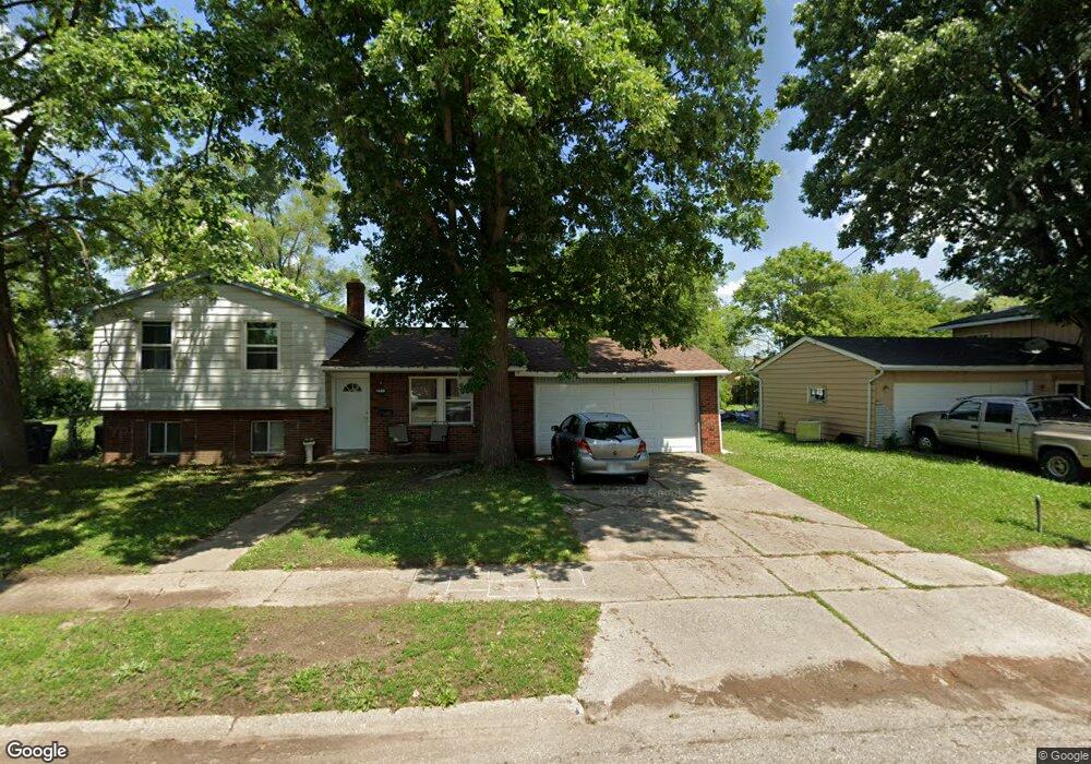
1609 Kent St Flint, MI 48503
South Parks NeighborhoodEstimated Value: $64,000 - $108,000
3
Beds
2
Baths
1,332
Sq Ft
$64/Sq Ft
Est. Value
About This Home
This home is located at 1609 Kent St, Flint, MI 48503 and is currently estimated at $85,000, approximately $63 per square foot. 1609 Kent St is a home located in Genesee County with nearby schools including Freeman Elementary School, Flint Southwestern Classical Academy, and International Academy of Flint (K-12).
Ownership History
Date
Name
Owned For
Owner Type
Purchase Details
Closed on
Aug 28, 2024
Sold by
Genesee County Land Bank Authority
Bought by
Cruz David Cardenas and Alvarez Dianisbel Coello
Current Estimated Value
Purchase Details
Closed on
Jan 30, 2017
Sold by
Stair Phillip G and Genesee County Land Bank Autho
Bought by
Hailey Olivia
Purchase Details
Closed on
May 14, 2012
Sold by
The Genesee County Land Bank Authority
Bought by
Hailey Olivia
Purchase Details
Closed on
Dec 21, 2011
Sold by
Genesee County Treasurer
Bought by
Genesee County Land Bank
Purchase Details
Closed on
Jul 25, 2005
Sold by
Fisher Edgar and Fisher Evelyn R
Bought by
Walker James E
Create a Home Valuation Report for This Property
The Home Valuation Report is an in-depth analysis detailing your home's value as well as a comparison with similar homes in the area
Home Values in the Area
Average Home Value in this Area
Purchase History
| Date | Buyer | Sale Price | Title Company |
|---|---|---|---|
| Cruz David Cardenas | $2,800 | None Listed On Document | |
| Hailey Olivia | $2,500 | None Available | |
| Hailey Olivia | $8,000 | None Available | |
| Genesee County Land Bank | -- | None Available | |
| Walker James E | $5,000 | Sargents Title Company |
Source: Public Records
Mortgage History
| Date | Status | Borrower | Loan Amount |
|---|---|---|---|
| Closed | Hailey Olivia | $0 |
Source: Public Records
Tax History Compared to Growth
Tax History
| Year | Tax Paid | Tax Assessment Tax Assessment Total Assessment is a certain percentage of the fair market value that is determined by local assessors to be the total taxable value of land and additions on the property. | Land | Improvement |
|---|---|---|---|---|
| 2025 | -- | $33,400 | $0 | $0 |
| 2024 | $792 | $0 | $0 | $0 |
| 2023 | $725 | $21,900 | $0 | $0 |
| 2022 | $0 | $19,700 | $0 | $0 |
| 2021 | $749 | $16,700 | $0 | $0 |
| 2020 | $683 | $13,100 | $0 | $0 |
| 2019 | $669 | $12,100 | $0 | $0 |
| 2018 | $655 | $11,300 | $0 | $0 |
| 2017 | $638 | $0 | $0 | $0 |
| 2016 | $634 | $0 | $0 | $0 |
| 2015 | -- | $0 | $0 | $0 |
| 2014 | -- | $0 | $0 | $0 |
| 2012 | -- | $0 | $0 | $0 |
Source: Public Records
Map
Nearby Homes
- 1851 Seymour Ave
- 1840 Mcphail St
- 1814 Mcphail St
- 1110 Pingree Ave
- 2029 Aitken Ave
- 9211 Owen St
- 1510 S Franklin Ave
- 2010 Crocker Ave
- 2221 Howard Ave
- 2224 Crocker Ave
- 2050 Ferris Ave
- 420 Pingree Ave
- 2013 E Court St
- 1925 Gilmartin St
- 1856 Tebo St
- 3373 Kent St
- 841 E 8th St
- 911 E 7th St
- 2131 Windemere Ave
- 2910 Shawnee Ave