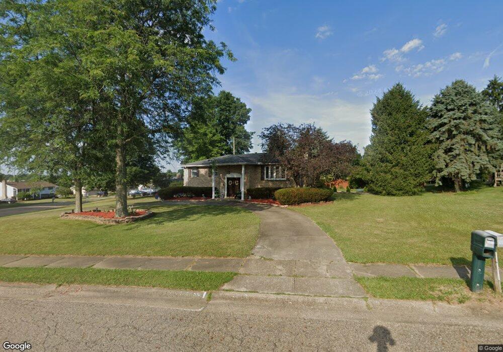
1609 Malone St Louisville, OH 44641
Estimated Value: $255,000 - $308,000
3
Beds
3
Baths
2,082
Sq Ft
$130/Sq Ft
Est. Value
About This Home
This home is located at 1609 Malone St, Louisville, OH 44641 and is currently estimated at $270,100, approximately $129 per square foot. 1609 Malone St is a home located in Stark County with nearby schools including Louisville High School and St. Thomas Aquinas High School & Middle School.
Ownership History
Date
Name
Owned For
Owner Type
Purchase Details
Closed on
Jun 30, 2010
Sold by
Woods Edward A
Bought by
Harbaugh Corie L
Current Estimated Value
Home Financials for this Owner
Home Financials are based on the most recent Mortgage that was taken out on this home.
Original Mortgage
$130,838
Outstanding Balance
$87,550
Interest Rate
4.86%
Mortgage Type
FHA
Estimated Equity
$182,550
Purchase Details
Closed on
Oct 2, 2003
Sold by
Woods Jeanne M
Bought by
Woods Edward A
Home Financials for this Owner
Home Financials are based on the most recent Mortgage that was taken out on this home.
Original Mortgage
$126,900
Interest Rate
7.59%
Mortgage Type
Purchase Money Mortgage
Purchase Details
Closed on
Apr 10, 2003
Sold by
Woods Edward A and Woods Jeanne M
Bought by
Woods Jeanne M
Create a Home Valuation Report for This Property
The Home Valuation Report is an in-depth analysis detailing your home's value as well as a comparison with similar homes in the area
Home Values in the Area
Average Home Value in this Area
Purchase History
| Date | Buyer | Sale Price | Title Company |
|---|---|---|---|
| Harbaugh Corie L | $107,800 | Netwide Title Agency Inc | |
| Woods Edward A | -- | -- | |
| Woods Jeanne M | -- | -- |
Source: Public Records
Mortgage History
| Date | Status | Borrower | Loan Amount |
|---|---|---|---|
| Open | Harbaugh Corie L | $130,838 | |
| Previous Owner | Woods Edward A | $126,900 |
Source: Public Records
Tax History Compared to Growth
Tax History
| Year | Tax Paid | Tax Assessment Tax Assessment Total Assessment is a certain percentage of the fair market value that is determined by local assessors to be the total taxable value of land and additions on the property. | Land | Improvement |
|---|---|---|---|---|
| 2025 | -- | $72,490 | $19,360 | $53,130 |
| 2024 | -- | $72,490 | $19,360 | $53,130 |
| 2023 | $2,480 | $57,720 | $15,120 | $42,600 |
| 2022 | $2,486 | $57,720 | $15,120 | $42,600 |
| 2021 | $2,493 | $57,720 | $15,120 | $42,600 |
| 2020 | $2,073 | $52,120 | $13,620 | $38,500 |
| 2019 | $2,082 | $51,420 | $13,340 | $38,080 |
| 2018 | $2,046 | $51,420 | $13,340 | $38,080 |
| 2017 | $1,862 | $45,160 | $11,100 | $34,060 |
| 2016 | $1,901 | $45,160 | $11,100 | $34,060 |
| 2015 | $1,906 | $45,160 | $11,100 | $34,060 |
| 2014 | $1,888 | $41,590 | $10,190 | $31,400 |
| 2013 | $948 | $41,590 | $10,190 | $31,400 |
Source: Public Records
Map
Nearby Homes
- 1561 Noel St
- 6285 California Ave
- 0 Pilot Knob Ave NE
- 0 Brookridge Ave
- 5700 Broadway Ave
- 0 Glenbar St
- 704 Reno Dr
- 5623 Shallow Creek Ave
- 6083 Apple St
- 300 Kennedy St
- 5470 Alcorn Ave
- 248 Menegay Rd
- 3047 Mcintosh Dr NE
- 2950 Mcintosh Dr NE
- 2956 Mcintosh Dr NE
- 2962 Mcintosh Dr NE
- 2951 Mcintosh Dr NE
- 2963 Mcintosh Dr NE
- 430 Honeycrisp Dr NE
- 428 Honeycrisp Dr NE
- 1619 Malone St
- 2010 Walsh St
- 1606 Malone St
- 1924 Walsh St
- 1618 Malone St
- 2017 Walsh St
- 2018 Walsh St
- 1631 Malone St
- 1616 Hiram St
- 1626 Malone St
- 1626 Hiram St
- 2027 Walsh St
- 1634 Malone St
- 1605 California Ave
- 2026 Walsh St
- 1579 California Ave
- 1634 Hiram St
- 1617 California Ave
- 2032 Walsh St
- 1569 California Ave