


161 Brown St Kennebunk, ME 04043
Estimated payment $4,252/month
Highlights
- Nearby Water Access
- Public Beach
- 5.77 Acre Lot
- Kennebunk High School Rated 9+
- View of Trees or Woods
- Property is near public transit
About This Lot
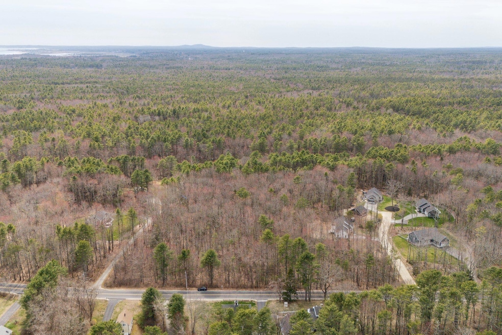
Rarely is land so well located as 161 Brown Street. This level 5.77 acre parcel is 1.4 miles from Parsons beach, 1.8 miles from downtown Kennebunk, and 3.7 miles to Dock Square in Kennebunkport. Adding to this, the property abuts Rachel Carson conservation land and the RC Preserve trails are less than 3 miles away. With so many recreational and shopping resources at your fingertips, you'd be hard pressed to find a lot of any size to match it. The lot itself is wooded, and bounded by other homes on both sides. If you're looking for a development opportunity or for privacy to build your dream homestead, this extraordinary property is perfect.
Property Details
Property Type
- Land
Est. Annual Taxes
- $3,148
Lot Details
- 5.77 Acre Lot
- Public Beach
- Level Lot
- Wooded Lot
- Property is zoned VR
Parking
- No Driveway
Utilities
- Electricity Not Available
- Natural Gas Not Available
- Well Required
- Septic Needed
- Sewer Not Available
Additional Features
- Views of Woods
- Property is near public transit
Listing and Financial Details
- Tax Lot 18
- Assessor Parcel Number KENB-000069-000000-000018
Community Details
Overview
- No Home Owners Association
Recreation
- Nearby Water Access
Map
Home Values in the Area
Average Home Value in this Area
Tax History
| Year | Tax Paid | Tax Assessment Tax Assessment Total Assessment is a certain percentage of the fair market value that is determined by local assessors to be the total taxable value of land and additions on the property. | Land | Improvement |
|---|---|---|---|---|
| 2024 | $3,148 | $185,700 | $185,700 | $0 |
| 2023 | $2,980 | $185,700 | $185,700 | $0 |
| 2022 | $2,711 | $185,700 | $185,700 | $0 |
| 2021 | $2,646 | $185,700 | $185,700 | $0 |
| 2020 | $2,628 | $185,700 | $185,700 | $0 |
| 2019 | $2,553 | $185,700 | $185,700 | $0 |
| 2018 | $4,783 | $149,300 | $139,300 | $10,000 |
| 2017 | $2,471 | $149,300 | $139,300 | $10,000 |
| 2016 | $4,608 | $149,300 | $139,300 | $10,000 |
| 2015 | $2,284 | $149,300 | $139,300 | $10,000 |
| 2014 | $2,225 | $149,300 | $139,300 | $10,000 |
Property History
| Date | Event | Price | Change | Sq Ft Price |
|---|---|---|---|---|
| 06/27/2025 06/27/25 | Pending | -- | -- | -- |
| 04/22/2025 04/22/25 | For Sale | $749,000 | -- | -- |
Purchase History
| Date | Type | Sale Price | Title Company |
|---|---|---|---|
| Quit Claim Deed | -- | -- |
Source: Maine Listings
MLS Number: 1619846
APN: KENB-000069-000000-000018
Disclaimer: Certain information contained herein is derived from information provided by parties other than Homes.com. All information provided is deemed reliable, but is not guaranteed to be accurate and should be independently verified.
![]() Listing data is derived in whole or in part from Maine Real Estate Information System, Inc. (d/b/a Maine Listings) and is for consumers' personal, noncommercial use only. Dimensions are approximate and not guaranteed. All data should be independently verified.
Listing data is derived in whole or in part from Maine Real Estate Information System, Inc. (d/b/a Maine Listings) and is for consumers' personal, noncommercial use only. Dimensions are approximate and not guaranteed. All data should be independently verified.
© 2025 Maine Real Estate Information System, Inc. All Rights Reserved. Equal Housing Opportunity.
Homes.com, LLC, 17600 Laguna Canyon Rd Irvine, CA 92618 (888)-952-6393
![]()
- 11 Mousam Ridge Rd
- 27 Webhannet Place Unit 16
- 4 Cider Mill Ln
- 11 Heritage Ln
- 17 Legacy Ln
- 30 York St Unit 1
- 24 York St
- 22 York St
- 17 Water St Unit 9
- 40 Shorebreezes Ln Unit 40
- 45 Summer St Unit 1
- 36 Shorebreeze Ln Unit 36
- 00 Summer St
- 86 Summer St
- 104 Summer St
- 54 Sycamore Ln Unit 19
- 5 Heath Rd
- 149 Western Ave
- 6 Old Port Rd
- 57 Southgate Rd
