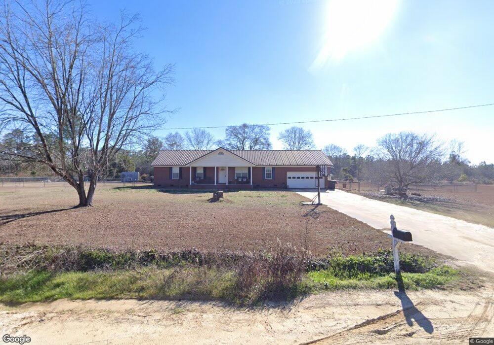
161 Cox Rd Sylvester, GA 31791
Estimated Value: $214,000 - $295,000
3
Beds
2
Baths
1,566
Sq Ft
$168/Sq Ft
Est. Value
About This Home
This home is located at 161 Cox Rd, Sylvester, GA 31791 and is currently estimated at $263,599, approximately $168 per square foot. 161 Cox Rd is a home located in Worth County with nearby schools including Worth County Primary School, Worth County Elementary School, and Worth County Middle School.
Ownership History
Date
Name
Owned For
Owner Type
Purchase Details
Closed on
Mar 31, 2004
Bought by
Stone Donnie A and Stone Amy F
Current Estimated Value
Create a Home Valuation Report for This Property
The Home Valuation Report is an in-depth analysis detailing your home's value as well as a comparison with similar homes in the area
Home Values in the Area
Average Home Value in this Area
Purchase History
| Date | Buyer | Sale Price | Title Company |
|---|---|---|---|
| Stone Donnie A | $163,000 | -- |
Source: Public Records
Tax History Compared to Growth
Tax History
| Year | Tax Paid | Tax Assessment Tax Assessment Total Assessment is a certain percentage of the fair market value that is determined by local assessors to be the total taxable value of land and additions on the property. | Land | Improvement |
|---|---|---|---|---|
| 2024 | $1,879 | $58,498 | $10,888 | $47,610 |
| 2023 | $1,879 | $58,050 | $10,888 | $47,162 |
| 2022 | $1,867 | $58,050 | $10,888 | $47,162 |
| 2021 | $1,844 | $58,050 | $10,888 | $47,162 |
| 2020 | $1,847 | $58,050 | $10,888 | $47,162 |
| 2019 | $1,847 | $58,050 | $10,888 | $47,162 |
| 2018 | $1,663 | $58,050 | $10,888 | $47,162 |
| 2017 | $1,663 | $58,050 | $10,888 | $47,162 |
| 2016 | $1,607 | $58,050 | $10,888 | $47,162 |
| 2015 | $1,610 | $58,050 | $10,888 | $47,162 |
| 2014 | $1,610 | $58,050 | $10,888 | $47,162 |
| 2013 | -- | $58,743 | $11,581 | $47,162 |
| 2012 | -- | $58,742 | $11,580 | $47,162 |
Source: Public Records
Map
Nearby Homes
- 128 Airport Rd
- 107 Gardner Rd
- 103 N Ayers St
- 101 Elm St
- 0 W Pinson St Unit 10582366
- 1011 N Washington St
- 1102 N Washington St
- 1007 N Isabella St
- 0 N Isabella St Unit 161570
- 701 N Isabella St
- 801 N Washington St
- 100 Carriage Ln
- 109 Huntington Ct
- 307 E Pope St
- 203 E Pinson St
- 1432 S Ga Hwy 33s
- 112 Creekwood Cir
- 710 S Jefferson St
- 115 Northlake Dr
- 316 Bell Rd
- 07 Cox Rd
- 12 Cox Rd
- 13 Cox Rd
- 14 Cox Rd
- 295 Youngblood Rd
- 156 Cox Rd
- 128 Cox Rd
- 216 Silver Lake Cir
- 119 Cox Rd
- 232 Silver Lake Cir
- 236 Silver Lake Cir
- 118 Cox Rd
- 223 Silver Lake Cir
- 201 Silver Lake Cir
- 306 Lakeside Cir
- 240 Silver Lake Cir
- 314 Lakeside Cir
- 291 Youngblood Rd
- 310 Lakeside Cir
- 318 Lakeside Cir