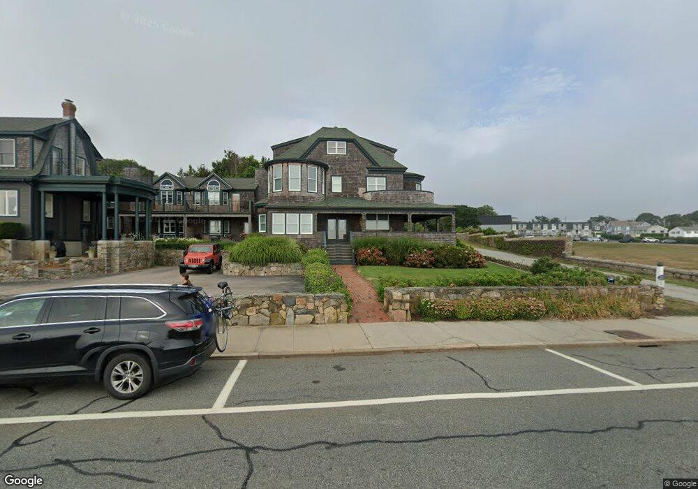
161 Ocean Rd Unit 11 Narragansett, RI 02882
Estimated Value: $1,600,335 - $1,839,000
5
Beds
4
Baths
2,900
Sq Ft
$601/Sq Ft
Est. Value
About This Home
This home is located at 161 Ocean Rd Unit 11, Narragansett, RI 02882 and is currently estimated at $1,742,445, approximately $600 per square foot. 161 Ocean Rd Unit 11 is a home located in Washington County with nearby schools including Narragansett Elementary School, Narragansett Pier Middle School, and Narragansett High School.
Ownership History
Date
Name
Owned For
Owner Type
Purchase Details
Closed on
Feb 28, 2000
Sold by
Berstein Irving A and Berstein Suzanne
Bought by
Sweeny James C and Sweeney Elaine P
Current Estimated Value
Home Financials for this Owner
Home Financials are based on the most recent Mortgage that was taken out on this home.
Original Mortgage
$150,000
Outstanding Balance
$49,550
Interest Rate
8.15%
Estimated Equity
$1,692,895
Create a Home Valuation Report for This Property
The Home Valuation Report is an in-depth analysis detailing your home's value as well as a comparison with similar homes in the area
Home Values in the Area
Average Home Value in this Area
Purchase History
| Date | Buyer | Sale Price | Title Company |
|---|---|---|---|
| Sweeny James C | $605,000 | -- |
Source: Public Records
Mortgage History
| Date | Status | Borrower | Loan Amount |
|---|---|---|---|
| Open | Sweeny James C | $150,000 | |
| Closed | Sweeny James C | $100,000 |
Source: Public Records
Tax History Compared to Growth
Tax History
| Year | Tax Paid | Tax Assessment Tax Assessment Total Assessment is a certain percentage of the fair market value that is determined by local assessors to be the total taxable value of land and additions on the property. | Land | Improvement |
|---|---|---|---|---|
| 2025 | $10,536 | $1,551,700 | $0 | $1,551,700 |
| 2024 | $10,164 | $1,551,700 | $0 | $1,551,700 |
| 2023 | $10,072 | $1,081,900 | $0 | $1,081,900 |
| 2022 | $9,685 | $1,076,100 | $0 | $1,076,100 |
| 2021 | $9,534 | $1,076,100 | $0 | $1,076,100 |
| 2020 | $10,179 | $971,300 | $0 | $971,300 |
| 2019 | $9,936 | $971,300 | $0 | $971,300 |
| 2018 | $9,664 | $971,300 | $0 | $971,300 |
| 2017 | $8,855 | $838,500 | $0 | $838,500 |
| 2016 | $8,452 | $838,500 | $0 | $838,500 |
| 2015 | $8,335 | $838,500 | $0 | $838,500 |
| 2014 | $8,726 | $869,100 | $0 | $869,100 |
Source: Public Records
Map
Nearby Homes
- 27 Westmoreland St
- 126 Boon St
- 16 Courtway St
- 140 S Pier Rd
- 0 Hazard Ave
- 20 Narragansett Ave Unit 905
- 137 Kingstown Rd
- 137A Kingstown Rd
- 56 Wanda St
- 30 Sweet Meadows Ct Unit 26
- 19 Castle Rd
- 38 Eisenhower Place
- 576 Point Judith Rd
- 580 Point Judith Rd
- 128 Camden Ct
- 60 Daytona Ave
- 62 Daytona Ave
- 73 Camden Ct
- 45 Cherry Ln Unit C
- 39 Hazard Ave
- 161 Ocean Rd Unit 12
- 161 Ocean Rd Unit 4
- 161 - B Ocean Rd Unit 12
- 163 Ocean Rd Unit A
- 163 Ocean Rd Unit B
- 163 Ocean Rd Unit 10
- 165 Ocean Rd Unit 4
- 165 Ocean Rd Unit 1
- 165 Ocean Rd Unit 2
- 165 Ocean Rd Unit 3
- 171 Ocean Rd Unit 8
- 171 Ocean Rd Unit 7
- 157 Ocean Rd
- 175 Ocean Rd Unit 6
- 175 Ocean Rd Unit 5
- 0 Congdon St
- 13 S Pier Rd
- 19 S Pier Rd
- 12 South Trail
- 179 Ocean Rd Unit B