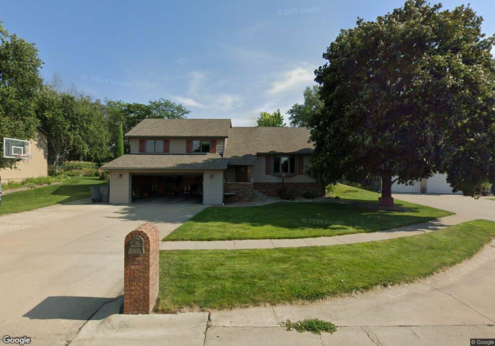
1610 Alaska Cir Norfolk, NE 68701
Estimated Value: $277,000 - $435,000
4
Beds
3
Baths
2,460
Sq Ft
$143/Sq Ft
Est. Value
About This Home
This home is located at 1610 Alaska Cir, Norfolk, NE 68701 and is currently estimated at $352,729, approximately $143 per square foot. 1610 Alaska Cir is a home located in Madison County with nearby schools including Norfolk Senior High School and St. Paul's Lutheran School.
Ownership History
Date
Name
Owned For
Owner Type
Purchase Details
Closed on
Dec 29, 2021
Sold by
Midtown Health Center Inc
Bought by
Orlowski Jr Llc
Current Estimated Value
Purchase Details
Closed on
Jun 29, 2021
Sold by
Miller David A and Miller Anita M
Bought by
Midtown Health Center Inc
Purchase Details
Closed on
Feb 25, 2004
Sold by
Rundell Alan C and Rundell Marie R
Bought by
Miller David A and Miller Anita M
Purchase Details
Closed on
Mar 2, 2001
Sold by
Gohring Richard D and Gohring Sandra L
Bought by
Rundell Alan C and Rundell Marie R
Create a Home Valuation Report for This Property
The Home Valuation Report is an in-depth analysis detailing your home's value as well as a comparison with similar homes in the area
Home Values in the Area
Average Home Value in this Area
Purchase History
| Date | Buyer | Sale Price | Title Company |
|---|---|---|---|
| Orlowski Jr Llc | $9,000 | Coople Rockey Schlecht & Mason | |
| Midtown Health Center Inc | $5,777 | Copple Rockey Schlecht & Mason | |
| Miller David A | $148,000 | -- | |
| Rundell Alan C | $140,000 | -- |
Source: Public Records
Tax History Compared to Growth
Tax History
| Year | Tax Paid | Tax Assessment Tax Assessment Total Assessment is a certain percentage of the fair market value that is determined by local assessors to be the total taxable value of land and additions on the property. | Land | Improvement |
|---|---|---|---|---|
| 2024 | $4,032 | $326,815 | $37,496 | $289,319 |
| 2023 | $5,739 | $310,438 | $37,496 | $272,942 |
| 2022 | $5,379 | $290,220 | $37,496 | $252,724 |
| 2021 | $4,983 | $269,353 | $37,496 | $231,857 |
| 2020 | $4,968 | $269,353 | $37,496 | $231,857 |
| 2019 | $4,817 | $252,178 | $37,496 | $214,682 |
| 2018 | $4,584 | $243,998 | $37,496 | $206,502 |
| 2017 | $4,281 | $227,643 | $37,496 | $190,147 |
| 2016 | $4,290 | $227,643 | $37,496 | $190,147 |
| 2015 | $4,291 | $227,643 | $37,496 | $190,147 |
| 2014 | $3,761 | $193,722 | $24,254 | $169,468 |
| 2013 | $3,660 | $182,635 | $24,254 | $158,381 |
Source: Public Records
Map
Nearby Homes
- 1601 Sheridan Dr
- 2001 Alaska Ave
- 1309 Galeta Ave
- 2116 Sheridan Dr
- 1603 Charolais Dr
- 1506 Charolais Dr
- 1704 Homewood Dr
- 1706 Homewood Dr Unit 2114 Collegeview
- 1705 Syracuse Ave
- 1508 Homewood Dr
- 1415 Charolais Dr
- 2206 Elmers Ln
- 1306 Hillview Dr
- 802 Ferguson Dr
- 1400 Charolais Dr
- 1407 Homewood Dr
- 1704 Laurel Ln
- 1208 Grant Ave
- 1203 Greenlawn Dr
- 2304 Highland Dr
- 1608 Alaska Cir
- 1700 Alaska Ave
- 1702 Alaska Ave
- 1606 Alaska Cir
- 1910 N 17th St
- 1911 N 17th St
- 2006 N 18th St
- 1704 Alaska Ave
- 1604 Alaska Cir
- 1602 Alaska Cir
- 1908 N 17th St
- 1909 N 17th St
- 1906 N 18th St
- 1906 N 17th Cir
- 1904 N 18th St
- 1907 N 17th St
- 1800 Alaska Ave
- 1904 N 17th Cir
- 1902 N 18th St
- 1901 N 17th St