Estimated payment $2,789/month
Highlights
- Popular Property
- Updated Kitchen
- Mountain View
- Lehi Junior High School Rated A-
- Mature Trees
- Vaulted Ceiling
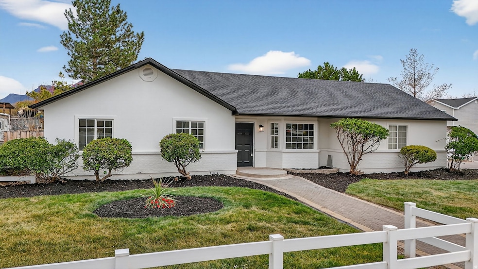
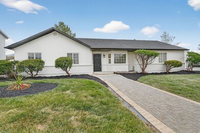
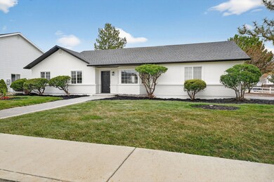
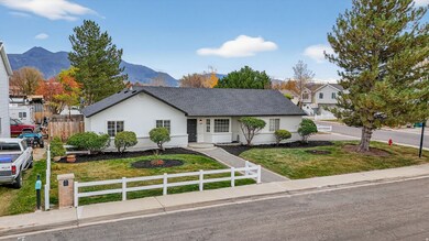
About This Home
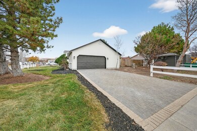
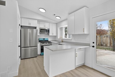
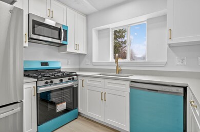
Stunning Lehi Gem! This beautiful, fully updated home in a centrally located neighborhood boasts a like-new interior with high-end finishes, including new kitchen cabinets, elegant quartz countertops, and durable LVP flooring. The large lot offers a private backyard and a spacious side yard with potential for a large shed, detached garage, or ADU. Enjoy peace of mind with a new roof, newer furnace, AC, and water heater. The oversized garage provides plenty of extra storage space. This exceptional property is an absolute must-see! Square footage figures are provided as a courtesy estimate only and were obtained from a previous listing. Buyer is advised to obtain an independent measurement.

Home Details
Home Type
- Single Family
Est. Annual Taxes
- $1,848
Year Built
- Built in 1993
Lot Details
- 8,276 Sq Ft Lot
- Partially Fenced Property
- Landscaped
- Mature Trees
- Zoning described as R1
Parking
- 2 Car Garage
Home Design
- Rambler Architecture
- Brick Exterior Construction
- Stucco
Interior Spaces
- 1,115 Sq Ft Home
- 1-Story Property
- Vaulted Ceiling
- Double Pane Windows
- Mountain Views
Kitchen
- Updated Kitchen
- Range with Range Hood
- Microwave
- Disposal
Bedrooms and Bathrooms
- 3 Main Level Bedrooms
Schools
- Lehi Elementary And Middle School
- Lehi High School
Additional Features
- Reclaimed Water Irrigation System
- Central Heating and Cooling System
Community Details
- No Home Owners Association
- Stonegate Subdivision
Listing and Financial Details
- Assessor Parcel Number 52-459-0014
Map
Home Values in the Area
Average Home Value in this Area
Tax History
| Year | Tax Paid | Tax Assessment Tax Assessment Total Assessment is a certain percentage of the fair market value that is determined by local assessors to be the total taxable value of land and additions on the property. | Land | Improvement |
|---|---|---|---|---|
| 2025 | $1,778 | $220,715 | $174,600 | $226,700 |
| 2024 | $1,778 | $208,065 | $0 | $0 |
| 2023 | $1,646 | $209,165 | $0 | $0 |
| 2022 | $1,774 | $218,515 | $0 | $0 |
| 2021 | $1,574 | $293,100 | $101,000 | $192,100 |
| 2020 | $1,483 | $273,000 | $93,500 | $179,500 |
| 2019 | $1,304 | $249,600 | $93,500 | $156,100 |
| 2018 | $1,313 | $237,600 | $88,600 | $149,000 |
| 2017 | $1,248 | $120,010 | $0 | $0 |
| 2016 | $1,281 | $114,290 | $0 | $0 |
| 2015 | $1,265 | $107,195 | $0 | $0 |
| 2014 | $1,232 | $103,730 | $0 | $0 |
Property History
| Date | Event | Price | List to Sale | Price per Sq Ft |
|---|---|---|---|---|
| 11/15/2025 11/15/25 | For Sale | $499,900 | -- | $448 / Sq Ft |
Purchase History
| Date | Type | Sale Price | Title Company |
|---|---|---|---|
| Warranty Deed | -- | Pioneer Title | |
| Special Warranty Deed | -- | Gt Title Services | |
| Warranty Deed | -- | -- |
Mortgage History
| Date | Status | Loan Amount | Loan Type |
|---|---|---|---|
| Previous Owner | $123,600 | VA |
Source: UtahRealEstate.com
MLS Number: 2123113
APN: 52-459-0014
Disclaimer: Certain information contained herein is derived from information provided by parties other than Homes.com. All information provided is deemed reliable, but is not guaranteed to be accurate and should be independently verified.
![]() IDX information is provided exclusively for consumers’ personal, non-commercial use, that it may not be used for any purpose other than to identify prospective properties consumers may be interested in purchasing, and that the data is deemed reliable but is not guaranteed accurate by the MLS. Licensor is only providing the MLS Content and not other sources of data provided in the Product.
IDX information is provided exclusively for consumers’ personal, non-commercial use, that it may not be used for any purpose other than to identify prospective properties consumers may be interested in purchasing, and that the data is deemed reliable but is not guaranteed accurate by the MLS. Licensor is only providing the MLS Content and not other sources of data provided in the Product.
Based on information from the Wasatch Front Regional Multiple Listing Service, Inc.. All data, including all measurements and calculations of area, is obtained from various sources and has not been, and will not be, verified by broker or the MLS. All information should be independently reviewed and verified for accuracy. Properties may or may not be listed by the office/agent presenting the information.
- 1272 W 1800 N
- 1094 W 1425 N
- 1011 W Mountain Way Unit 316
- 902 W 1500 N
- 1817 W Bad Rock Cir
- 1332 W 1500 N
- 1301 N 900 W Unit 12
- 1132 Titan Dr
- 1627 W Boxwood Dr Unit 110
- 1659 W Boxwood Dr Unit 109
- 1032 Titan Dr
- 1127 N 1500 W
- 1542 N 1900 W
- 595 W 2200 N
- 2287 N 750 W
- 1755 N 250 W
- 497 W 2200 N
- 5312 N Springview Ct Unit 106
- 1027 N 3685 W Unit 248
- 2191 W Swift Fox Dr Unit 274
- 1788 N Festive Way
- 1971 W 1400 N
- 2377 N 1200 W
- 570 W 2375 N St
- 1995 N 3930 W
- 339 W 2450 N
- 2777 W Sandalwood Dr
- 1054 W Main St
- 2718 N Elm Dr
- 3601 N Mountain View Rd
- 591 S Emerald Ln Unit Basement ADU
- 4206 W 1960 N Unit Private 3
- 2884 N 675 E
- 3851 N Traverse Mountain Blvd
- 1848 W 700 S
- 2776 Willow Way
- 946 Shadow Brk Ln
- 3670 W Canyon Falls Dr
- 4200 N Seasons View Dr
- 3695 Big Horn Dr