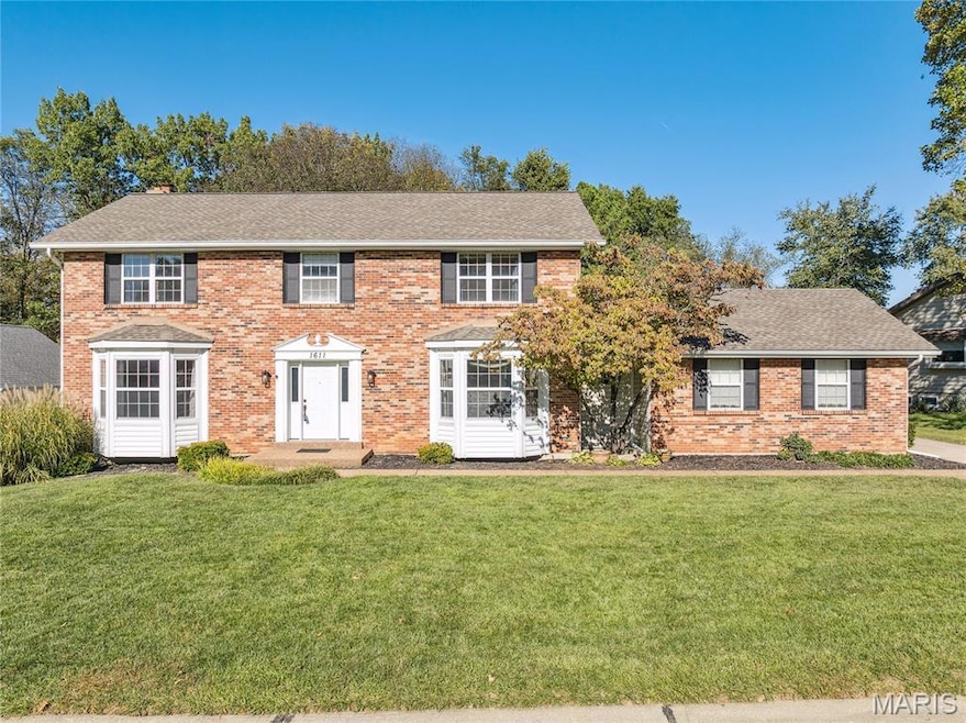
1611 Burnside Ln Saint Charles, MO 63303
Heritage NeighborhoodEstimated payment $2,881/month
Highlights
- Traditional Architecture
- 1 Fireplace
- Brick Veneer
- Becky-David Elementary School Rated A
- 2 Car Attached Garage
- Patio
About This Home
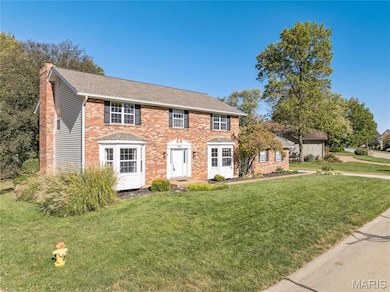
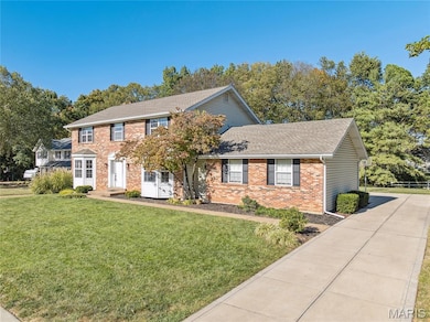
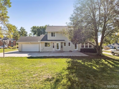
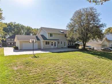
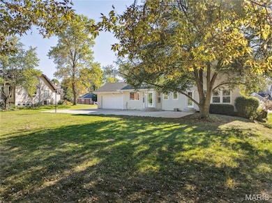
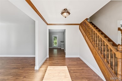
Beautiful 2-Story Brick Home in the Heart of St. Charles! Nestled on a quiet cul-de-sac in unincorporated St. Charles, this stunning 4-bedroom, 3.5-bath home offers the perfect blend of space and comfort. Situated on over a third of an acre, this property boasts a level, private lot ideal for relaxing or entertaining. Step inside to find updated hardwood floors throughout the main level, a separate dining room and sitting room, and a welcoming living room with a cozy fireplace. The updated kitchen features stylish finishes, plenty of cabinet space, and easy access to the oversized patio, perfect for outdoor gatherings. Upstairs, you’ll find generously sized bedrooms including a spacious primary suite. The finished basement offers even more living space—great for a family room, home gym, entertaining guests or office. Additional highlights include a newer roof, 2-car garage, and location in a top-rated school district. Enjoy the convenience of being close to shopping, dining, and parks—all while tucked away in a peaceful neighborhood setting. Don’t miss your chance to own this move-in ready gem in one of St. Charles’ most desirable areas!
Home Details
Home Type
- Single Family
Est. Annual Taxes
- $4,519
Year Built
- Built in 1984
HOA Fees
- $21 Monthly HOA Fees
Parking
- 2 Car Attached Garage
Home Design
- Traditional Architecture
- Brick Veneer
- Vinyl Siding
Interior Spaces
- 3,237 Sq Ft Home
- 2-Story Property
- Ceiling Fan
- 1 Fireplace
Bedrooms and Bathrooms
- 4 Bedrooms
Partially Finished Basement
- Basement Ceilings are 8 Feet High
- Finished Basement Bathroom
- Basement Storage
Schools
- Becky-David Elem. Elementary School
- Barnwell Middle School
- Francis Howell North High School
Utilities
- Central Air
- Natural Gas Connected
- Wi-Fi Available
- Phone Available
- Cable TV Available
Additional Features
- Patio
- 0.36 Acre Lot
Community Details
- Heritage Residents Association
Listing and Financial Details
- Assessor Parcel Number 3-0014-5692-00-0509.0000000
Map
Home Values in the Area
Average Home Value in this Area
Tax History
| Year | Tax Paid | Tax Assessment Tax Assessment Total Assessment is a certain percentage of the fair market value that is determined by local assessors to be the total taxable value of land and additions on the property. | Land | Improvement |
|---|---|---|---|---|
| 2025 | $4,519 | $82,100 | -- | -- |
| 2023 | $4,513 | $73,121 | -- | -- |
| 2022 | $4,097 | $61,474 | $0 | $0 |
| 2021 | $4,089 | $61,474 | $0 | $0 |
| 2020 | $3,974 | $58,235 | $0 | $0 |
| 2019 | $3,959 | $58,235 | $0 | $0 |
| 2018 | $3,558 | $49,931 | $0 | $0 |
| 2017 | $3,540 | $49,931 | $0 | $0 |
| 2016 | $3,412 | $48,263 | $0 | $0 |
| 2015 | $3,377 | $48,263 | $0 | $0 |
| 2014 | $3,253 | $45,070 | $0 | $0 |
Property History
| Date | Event | Price | List to Sale | Price per Sq Ft |
|---|---|---|---|---|
| 12/11/2025 12/11/25 | Pending | -- | -- | -- |
| 12/08/2025 12/08/25 | Price Changed | $474,900 | -4.1% | $147 / Sq Ft |
| 10/24/2025 10/24/25 | For Sale | $495,000 | -- | $153 / Sq Ft |
Purchase History
| Date | Type | Sale Price | Title Company |
|---|---|---|---|
| Warranty Deed | -- | None Listed On Document | |
| Warranty Deed | $183,000 | -- |
Mortgage History
| Date | Status | Loan Amount | Loan Type |
|---|---|---|---|
| Previous Owner | $108,000 | No Value Available |
Source: MARIS MLS
MLS Number: MIS25070309
APN: 3-0014-5692-00-0509.0000000
Disclaimer: Certain information contained herein is derived from information provided by parties other than Homes.com. All information provided is deemed reliable, but is not guaranteed to be accurate and should be independently verified.
![]() Based on information submitted to the MLS GRID. All data is obtained from various sources and may not have been verified by broker or MLS GRID. Supplied Open House Information is subject to change without notice. All information should be independently reviewed and verified for accuracy. Properties may or may not be listed by the office/agent presenting the information. Some IDX listings have been excluded from this website.
Based on information submitted to the MLS GRID. All data is obtained from various sources and may not have been verified by broker or MLS GRID. Supplied Open House Information is subject to change without notice. All information should be independently reviewed and verified for accuracy. Properties may or may not be listed by the office/agent presenting the information. Some IDX listings have been excluded from this website.
The Digital Millennium Copyright Act of 1998, 17 U.S.C. § 512 (the “DMCA”) provides recourse for copyright owners who believe that material appearing on the Internet infringes their rights under U.S. copyright law. If you believe in good faith that any content or material made available in connection with our website or services infringes your copyright, you (or your agent) may send us a notice requesting that the content or material be removed, or access to it blocked.
Notices must be sent in writing by email to DMCAnotice@MLSGrid.com.
The DMCA requires that your notice of alleged copyright infringement include the following information:
(1) description of the copyrighted work that is the subject of claimed infringement;
(2) description of the alleged infringing content and information sufficient to permit us to locate the content;
(3) contact information for you, including your address, telephone number and email address;
(4) a statement by you that you have a good faith belief that the content in the manner complained of is not authorized by the copyright owner, or its agent, or by the operation of any law;
(5) a statement by you, signed under penalty of perjury, that the information in the notification is accurate and that you have the authority to enforce the copyrights that are claimed to be infringed; and
(6) a physical or electronic signature of the copyright owner or a person authorized to act on the copyright owner’s behalf. Failure to include all of the above information may result in the delay of the processing of your complaint.
- 726 Gran Lin Dr
- 1355 Hampton Rd Unit B
- 3010 Paddlewheel Ct
- 2962 Brooklands Way
- 934 Silverstone Dr
- 1448 Gettysburg Landing
- 2949 Oetting Dr
- 1449 Gettysburg Landing
- 2609 Plantation Point Unit D
- 2605 Plantation Point Unit B
- 2617 Hampton Rd Unit C
- 506 Newkirk Cir
- 1004 Cobbler Ln
- 1465 Heritage Landing Unit 35
- 1465 Heritage Landing Unit 306
- 1465 Heritage Landing Unit 46 (410)
- 3058 Plum Creek Dr
- 1380 Heritage Landing Unit 307
- 1380 Heritage Landing Unit 206
- 1440 Heritage Landing Unit 309
