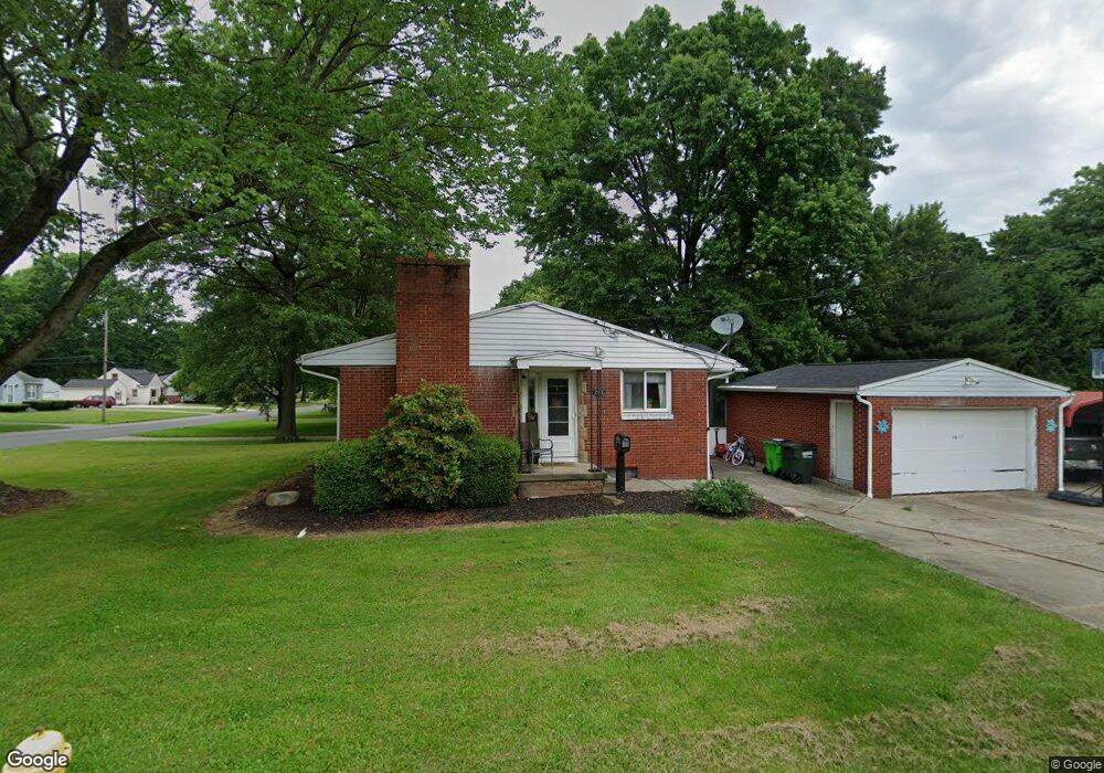
1611 Maple St Barberton, OH 44203
Johnson's Corners NeighborhoodEstimated Value: $216,939 - $240,000
3
Beds
2
Baths
1,305
Sq Ft
$174/Sq Ft
Est. Value
About This Home
This home is located at 1611 Maple St, Barberton, OH 44203 and is currently estimated at $226,985, approximately $173 per square foot. 1611 Maple St is a home located in Summit County with nearby schools including Barberton Middle School, Barberton High School, and Hametown Christian Academy.
Ownership History
Date
Name
Owned For
Owner Type
Purchase Details
Closed on
Jun 13, 2006
Sold by
Wallace John K and Wallace Julie A Morgan
Bought by
Hull Scott J and Hull Stefanie L
Current Estimated Value
Home Financials for this Owner
Home Financials are based on the most recent Mortgage that was taken out on this home.
Original Mortgage
$131,138
Outstanding Balance
$77,572
Interest Rate
6.68%
Mortgage Type
FHA
Estimated Equity
$149,413
Purchase Details
Closed on
May 31, 1996
Sold by
Est Daniel J Pfeiffer
Bought by
Wallace John K and Morgan Julie A
Home Financials for this Owner
Home Financials are based on the most recent Mortgage that was taken out on this home.
Original Mortgage
$95,000
Interest Rate
7.99%
Mortgage Type
New Conventional
Create a Home Valuation Report for This Property
The Home Valuation Report is an in-depth analysis detailing your home's value as well as a comparison with similar homes in the area
Home Values in the Area
Average Home Value in this Area
Purchase History
| Date | Buyer | Sale Price | Title Company |
|---|---|---|---|
| Hull Scott J | $136,000 | Approved Statewide Title Age | |
| Wallace John K | $105,000 | -- |
Source: Public Records
Mortgage History
| Date | Status | Borrower | Loan Amount |
|---|---|---|---|
| Open | Hull Scott J | $131,138 | |
| Closed | Wallace John K | $95,000 |
Source: Public Records
Tax History
| Year | Tax Paid | Tax Assessment Tax Assessment Total Assessment is a certain percentage of the fair market value that is determined by local assessors to be the total taxable value of land and additions on the property. | Land | Improvement |
|---|---|---|---|---|
| 2025 | $3,317 | $66,371 | $12,383 | $53,988 |
| 2024 | $3,317 | $66,371 | $12,383 | $53,988 |
| 2023 | $3,317 | $66,371 | $12,383 | $53,988 |
| 2022 | $2,732 | $47,408 | $8,845 | $38,563 |
| 2021 | $2,729 | $47,408 | $8,845 | $38,563 |
| 2020 | $2,670 | $47,410 | $8,850 | $38,560 |
| 2019 | $2,525 | $40,600 | $7,220 | $33,380 |
| 2018 | $2,487 | $40,600 | $7,220 | $33,380 |
| 2017 | $2,237 | $40,600 | $7,220 | $33,380 |
| 2016 | $2,242 | $36,050 | $7,220 | $28,830 |
| 2015 | $2,237 | $36,050 | $7,220 | $28,830 |
| 2014 | $2,225 | $36,050 | $7,220 | $28,830 |
| 2013 | $2,326 | $39,070 | $7,220 | $31,850 |
Source: Public Records
Map
Nearby Homes
- 255 Taylor Rd
- 000 Haynes Ave
- 3626 Johnson Rd
- 407 31st St SW
- 1371 Benton St
- V/L Benton
- 1193 Stratford St
- 1125 Prospect St
- 4527 Rock Cut Rd
- 1099 Prospect St
- 1080 Stratford St
- 1288 Liberty Ave
- 39 25th St NW
- 36 23rd St SW
- 67 25th St NW
- 1338 Oak Ave
- 131 25th St NW
- 30 22nd St NW
- 246 29th St NW
- 48 20th St SW
Your Personal Tour Guide
Ask me questions while you tour the home.