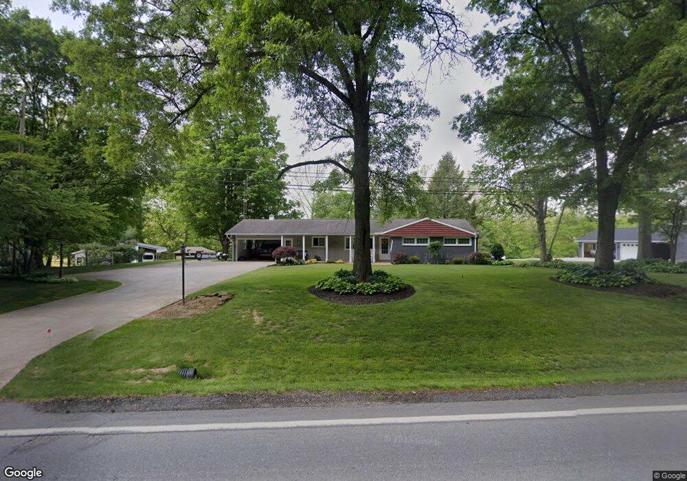
1611 State Route 97 Butler, OH 44822
Estimated Value: $228,000 - $252,000
3
Beds
3
Baths
1,420
Sq Ft
$170/Sq Ft
Est. Value
About This Home
This home is located at 1611 State Route 97, Butler, OH 44822 and is currently estimated at $241,425, approximately $170 per square foot. 1611 State Route 97 is a home located in Richland County with nearby schools including Clear Fork High School.
Ownership History
Date
Name
Owned For
Owner Type
Purchase Details
Closed on
Nov 6, 2015
Sold by
Pore Robet Leon and Pore Constance C
Bought by
Pore Robert L and Pore Constance C
Current Estimated Value
Purchase Details
Closed on
Feb 1, 1999
Sold by
Pore John E
Bought by
Pore Robert L and Pore Constance C
Home Financials for this Owner
Home Financials are based on the most recent Mortgage that was taken out on this home.
Original Mortgage
$70,000
Interest Rate
6.75%
Mortgage Type
New Conventional
Create a Home Valuation Report for This Property
The Home Valuation Report is an in-depth analysis detailing your home's value as well as a comparison with similar homes in the area
Home Values in the Area
Average Home Value in this Area
Purchase History
| Date | Buyer | Sale Price | Title Company |
|---|---|---|---|
| Pore Robert L | -- | Attorney | |
| Pore Robert L | $100,000 | -- |
Source: Public Records
Mortgage History
| Date | Status | Borrower | Loan Amount |
|---|---|---|---|
| Closed | Pore Robert L | $70,000 |
Source: Public Records
Tax History Compared to Growth
Tax History
| Year | Tax Paid | Tax Assessment Tax Assessment Total Assessment is a certain percentage of the fair market value that is determined by local assessors to be the total taxable value of land and additions on the property. | Land | Improvement |
|---|---|---|---|---|
| 2024 | $1,694 | $46,390 | $6,960 | $39,430 |
| 2023 | $1,694 | $46,390 | $6,960 | $39,430 |
| 2022 | $1,514 | $37,770 | $6,610 | $31,160 |
| 2021 | $1,641 | $37,770 | $6,610 | $31,160 |
| 2020 | $1,641 | $37,770 | $6,610 | $31,160 |
| 2019 | $1,469 | $32,030 | $5,600 | $26,430 |
| 2018 | $1,455 | $32,030 | $5,600 | $26,430 |
| 2017 | $1,431 | $32,030 | $5,600 | $26,430 |
| 2016 | $1,464 | $33,110 | $5,250 | $27,860 |
| 2015 | $1,462 | $33,110 | $5,250 | $27,860 |
| 2014 | $1,460 | $33,110 | $5,250 | $27,860 |
| 2012 | $714 | $33,110 | $5,250 | $27,860 |
Source: Public Records
Map
Nearby Homes
- 224 Blue Bird Dr
- 128 College St
- 3898 Ohio 97
- 1259 State Route 97 E
- 1260 Ohio 97 Unit 115
- 5449 Hagerman Rd
- 2070 Riggle Rd
- 1169 State Route 97 E
- 5042 Possum Run Rd
- 4978 Bott Rd
- 0 Kenton Rd
- 4234 Swigart Rd
- 0 Mishey Rd
- 6533 Durbin Rd
- 0 Mill Rd
- 70 Betty Dr
- 6509 Ankneytown Rd
- 74 E Durbin Ave
- 32 Betty Dr
- 1302 Hathaway Rd
- 1603 State Route 97
- 1603 State Route 97
- 1617 State Route 97
- 1634 State Route 97
- 1624 State Route 97
- 1597 State Route 97
- 1815 Gatton Rock Rd
- 1648 State Route 97
- 1795 Gatton Rock Rd
- 1666 State Route 97
- 1672 State Route 97
- 1944 Snyder Rd
- 1924 Snyder Rd
- 1759 Cutnaw Rd Unit 311
- 271 Highland Dr
- 261 Highland Dr
- 1988 Snyder Rd
- 279 Forest Ave
- 0 Forest Ave Unit 9026398
- 0 Forest Ave Unit 9038379