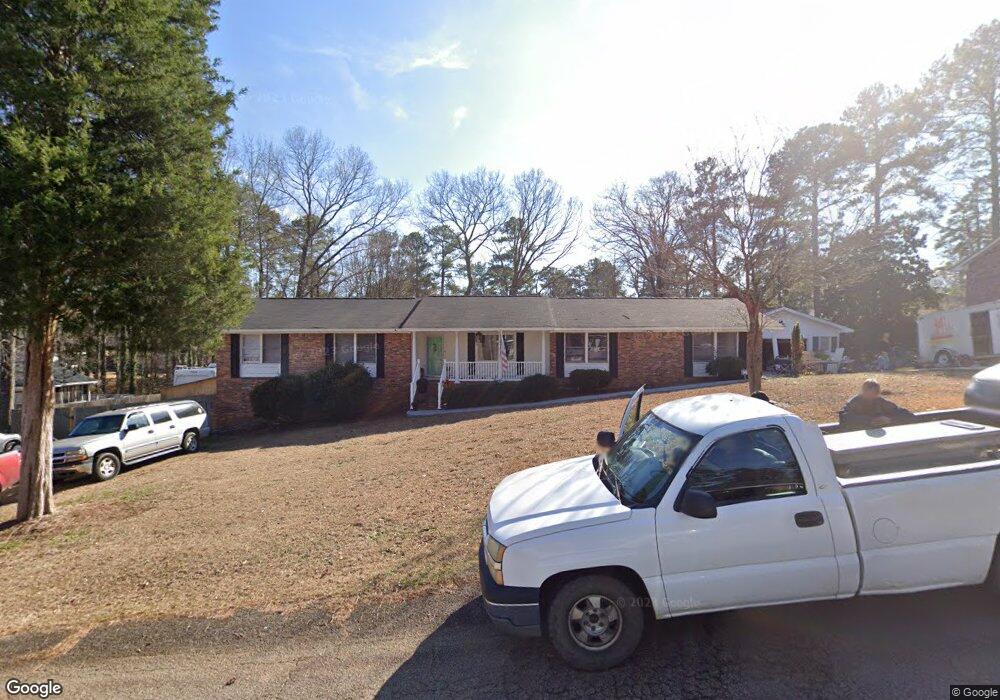
1613 Carl Rd Columbia, SC 29210
Saint Andrews NeighborhoodEstimated Value: $245,447 - $265,000
3
Beds
2
Baths
2,014
Sq Ft
$126/Sq Ft
Est. Value
About This Home
This home is located at 1613 Carl Rd, Columbia, SC 29210 and is currently estimated at $253,862, approximately $126 per square foot. 1613 Carl Rd is a home located in Richland County with nearby schools including H. B. Rhame Elementary School, St. Andrews Middle School, and Columbia High School.
Ownership History
Date
Name
Owned For
Owner Type
Purchase Details
Closed on
Jun 3, 2015
Sold by
Littrell Emily P and Littrell Daniel B
Bought by
Cortes Sylvia and Cortes Russell
Current Estimated Value
Home Financials for this Owner
Home Financials are based on the most recent Mortgage that was taken out on this home.
Original Mortgage
$72,000
Outstanding Balance
$55,487
Interest Rate
3.77%
Mortgage Type
New Conventional
Estimated Equity
$198,375
Purchase Details
Closed on
Apr 27, 2011
Sold by
Owens James Kevin and Owens Leslie Robbins
Bought by
Littrell Emily P and Littrell Daniel B
Home Financials for this Owner
Home Financials are based on the most recent Mortgage that was taken out on this home.
Original Mortgage
$112,000
Interest Rate
4.74%
Mortgage Type
New Conventional
Create a Home Valuation Report for This Property
The Home Valuation Report is an in-depth analysis detailing your home's value as well as a comparison with similar homes in the area
Home Values in the Area
Average Home Value in this Area
Purchase History
| Date | Buyer | Sale Price | Title Company |
|---|---|---|---|
| Cortes Sylvia | $59,653 | -- | |
| Littrell Emily P | $142,000 | -- |
Source: Public Records
Mortgage History
| Date | Status | Borrower | Loan Amount |
|---|---|---|---|
| Open | Cortes Sylvia | $72,000 | |
| Previous Owner | Littrell Emily P | $112,000 |
Source: Public Records
Tax History Compared to Growth
Tax History
| Year | Tax Paid | Tax Assessment Tax Assessment Total Assessment is a certain percentage of the fair market value that is determined by local assessors to be the total taxable value of land and additions on the property. | Land | Improvement |
|---|---|---|---|---|
| 2024 | $1,473 | $162,900 | $0 | $0 |
| 2023 | $1,413 | $5,664 | $0 | $0 |
| 2022 | $1,281 | $141,600 | $17,100 | $124,500 |
| 2021 | $1,282 | $5,660 | $0 | $0 |
| 2020 | $1,303 | $5,660 | $0 | $0 |
| 2019 | $1,280 | $5,660 | $0 | $0 |
| 2018 | $1,263 | $5,640 | $0 | $0 |
| 2017 | $1,235 | $5,640 | $0 | $0 |
| 2016 | $1,230 | $5,640 | $0 | $0 |
| 2015 | $1,115 | $5,160 | $0 | $0 |
| 2014 | $1,082 | $128,900 | $0 | $0 |
| 2013 | -- | $5,160 | $0 | $0 |
Source: Public Records
Map
Nearby Homes
- 1712 Omarest Dr
- 1650 Omarest Dr
- 1820 Omarest Dr
- 201 Burbank St
- 232 Burbank St
- 214 River Bluff Way
- 105 River Bluff Ct
- 1850 Atlantic Dr
- 1850 Atlantic Dr Unit 416
- 112 Gateway Ln
- 321 Cambout St
- 1913 Grays Inn Rd
- 529 Cambout St
- 409 Huntley Way
- 1510 Canal Dr
- 1230 Greenville Cir
- 2103 Marley Dr
- 0 Marley Dr Unit 623584
- 1904 Elise Dr
- 2006 Mary Hill Dr