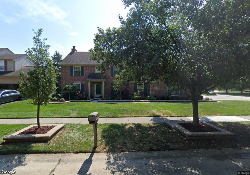
1614 Crestview Dr Canton, MI 48188
Estimated Value: $469,000 - $547,000
Studio
3
Baths
2,539
Sq Ft
$197/Sq Ft
Est. Value
About This Home
This home is located at 1614 Crestview Dr, Canton, MI 48188 and is currently estimated at $499,733, approximately $196 per square foot. 1614 Crestview Dr is a home located in Wayne County with nearby schools including Canton High School, Salem High School, and Plymouth High School.
Ownership History
Date
Name
Owned For
Owner Type
Purchase Details
Closed on
Oct 30, 2015
Sold by
Lipkin Timothy
Bought by
Lipkin Timothy and Lipkin Phyllis E
Current Estimated Value
Purchase Details
Closed on
Oct 15, 2015
Sold by
Lipkin Timothy
Bought by
Lipkin Timothy L
Purchase Details
Closed on
Jun 24, 2013
Sold by
Wells Fargo Bank National Association
Bought by
Lipkin Timothy
Purchase Details
Closed on
Apr 9, 2013
Sold by
Lipkin Timothy
Bought by
Wells Fargo Bank National Association and Wachovia Mortgage Fsb
Purchase Details
Closed on
Apr 22, 2005
Sold by
Denton John D and Denton Susan M
Bought by
Lipkins Timothy
Create a Home Valuation Report for This Property
The Home Valuation Report is an in-depth analysis detailing your home's value as well as a comparison with similar homes in the area
Home Values in the Area
Average Home Value in this Area
Purchase History
| Date | Buyer | Sale Price | Title Company |
|---|---|---|---|
| Lipkin Timothy | -- | None Available | |
| Lipkin Timothy L | $61,298 | Attorney | |
| Lipkin Timothy | $116,428 | None Available | |
| Wells Fargo Bank National Association | $115,476 | None Available | |
| Lipkins Timothy | $310,000 | Multiple |
Source: Public Records
Tax History
| Year | Tax Paid | Tax Assessment Tax Assessment Total Assessment is a certain percentage of the fair market value that is determined by local assessors to be the total taxable value of land and additions on the property. | Land | Improvement |
|---|---|---|---|---|
| 2025 | $3,005 | $260,700 | $0 | $0 |
| 2024 | $2,919 | $238,400 | $0 | $0 |
| 2023 | $2,783 | $209,800 | $0 | $0 |
| 2022 | $6,040 | $184,900 | $0 | $0 |
| 2021 | $5,861 | $182,100 | $0 | $0 |
| 2020 | $5,789 | $181,400 | $0 | $0 |
| 2019 | $5,684 | $172,180 | $0 | $0 |
| 2018 | $2,346 | $152,380 | $0 | $0 |
| 2017 | $5,457 | $147,400 | $0 | $0 |
| 2016 | $4,569 | $136,400 | $0 | $0 |
| 2015 | $11,454 | $126,200 | $0 | $0 |
| 2013 | $11,642 | $116,420 | $0 | $0 |
| 2010 | -- | $112,140 | $63,732 | $48,408 |
Source: Public Records
Map
Nearby Homes
- 40049 Rolling Green Ct
- 1786 Daisey Ln Unit 32
- 2393 Arcadia Dr
- 2087 Arcadia Dr Unit 65
- 1260 S John Hix St
- 39209 Nottingham St
- 569 Worthington Rd
- 39615 Kirkland Dr
- 2618 Hannan Rd
- 00000 Avondale St
- 41009 Southwind Dr Unit 108
- 000 S Lotz Rd
- 41060 Northwind Dr
- 41226 Southwind Dr Unit 138
- 41128 Northwind Dr Unit 28
- 1878 Otter Pond Ln
- 352 Cherry Hill Pointe Dr Unit 33
- 0 Cherry Hill Unit 16924
- 38249 N Jean Ct
- 3020 Rivers Edge Dr
- 1641 Dunston Rd
- 1622 Crestview Dr
- 1630 Crestview Dr
- 1653 Dunston Rd
- 1579 Dunston Rd
- 1618 Dunston Rd
- 1600 Dunston Rd
- 1634 Dunston Rd
- 1625 Crestview Dr
- 1588 Dunston Rd
- 1648 Dunston Rd
- 1675 Dunston Rd
- 1563 Dunston Rd
- 1668 Crestview Dr
- 1710 Crestview Dr
- 1633 Crestview Dr
- 1572 Dunston Rd
- 1718 Crestview Dr
- 1662 Dunston Rd
- 1689 Dunston Rd
Your Personal Tour Guide
Ask me questions while you tour the home.