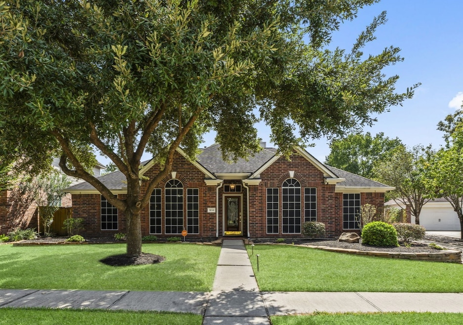


1614 Mercoal Dr Spring, TX 77386
Imperial Oaks NeighborhoodEstimated payment $3,025/month
Highlights
- Tennis Courts
- Heated Pool and Spa
- Clubhouse
- Kaufman Elementary School Rated A
- Located in a master-planned community
- Deck
About This Home
NEW ROOF 11/2025. Beautiful single-story brick home featuring 4 spacious bedrooms and 2 baths with an open, light-filled layout that feels both elegant and inviting. Thoughtful details shine throughout—crown moulding, solid wood floors, tile in key areas, LVT in guests, new carpet in the primary suite, and architectural accents that add warmth and charm. The open kitchen flows seamlessly into the dining and family rooms, creating the perfect setting for both everyday living and entertaining. Step outside to your own resort-style retreat with a heated PebbleTec saltwater pool and spa, all controlled by remote, plus plenty of patio space for lounging or dining. An oversized garage with workshop offers extra storage and workspace, while a 26KW whole-house generator ensures year-round peace of mind. Ideally located just minutes from The Woodlands, you’ll have quick access to shopping, dining, medical, and entertainment. A true blend of comfort, style, and convenience—this home has it all!

Home Details
Home Type
- Single Family
Est. Annual Taxes
- $7,802
Year Built
- Built in 1996
Lot Details
- 9,374 Sq Ft Lot
- Lot Dimensions are 67 x 121 x 89 x 124
- Northeast Facing Home
- Back Yard Fenced
- Sprinkler System
- Additional Parcels
HOA Fees
- $51 Monthly HOA Fees
Parking
- 2 Car Detached Garage
- Oversized Parking
- Workshop in Garage
Home Design
- Traditional Architecture
- Brick Exterior Construction
- Slab Foundation
- Composition Roof
Interior Spaces
- 2,818 Sq Ft Home
- 1-Story Property
- Wired For Sound
- Crown Molding
- Vaulted Ceiling
- Ceiling Fan
- Gas Log Fireplace
- Window Treatments
- Solar Screens
- Formal Entry
- Family Room Off Kitchen
- Living Room
- Breakfast Room
- Dining Room
- Open Floorplan
- Utility Room
- Washer and Gas Dryer Hookup
- Fire and Smoke Detector
Kitchen
- Breakfast Bar
- Electric Oven
- Gas Cooktop
- Microwave
- Dishwasher
- Kitchen Island
- Disposal
Flooring
- Wood
- Carpet
- Tile
- Vinyl Plank
- Vinyl
Bedrooms and Bathrooms
- 4 Bedrooms
- 2 Full Bathrooms
- Double Vanity
- Single Vanity
- Soaking Tub
- Separate Shower
Eco-Friendly Details
- Energy-Efficient Thermostat
Pool
- Heated Pool and Spa
- Heated In Ground Pool
- Saltwater Pool
Outdoor Features
- Tennis Courts
- Deck
- Covered Patio or Porch
- Separate Outdoor Workshop
- Shed
Schools
- Kaufman Elementary School
- Irons Junior High School
- Oak Ridge High School
Utilities
- Central Heating and Cooling System
- Heating System Uses Gas
- Programmable Thermostat
- Power Generator
Community Details
Overview
- Association fees include clubhouse, common areas, recreation facilities
- Imperial Oaks Poa, Phone Number (281) 296-8000
- Imperial Oaks 02 Subdivision
- Located in a master-planned community
Amenities
- Picnic Area
- Clubhouse
Recreation
- Tennis Courts
- Community Basketball Court
- Community Playground
- Community Pool
- Park
- Dog Park
Map
Home Values in the Area
Average Home Value in this Area
Tax History
| Year | Tax Paid | Tax Assessment Tax Assessment Total Assessment is a certain percentage of the fair market value that is determined by local assessors to be the total taxable value of land and additions on the property. | Land | Improvement |
|---|---|---|---|---|
| 2025 | $2,955 | $394,757 | $58,000 | $336,757 |
| 2024 | $2,812 | $370,359 | -- | -- |
| 2023 | $2,812 | $336,690 | $58,000 | $336,320 |
| 2022 | $7,059 | $306,080 | $11,530 | $353,480 |
| 2021 | $6,908 | $278,250 | $11,530 | $266,720 |
| 2020 | $7,191 | $278,250 | $11,530 | $266,720 |
| 2019 | $6,427 | $254,580 | $11,530 | $243,050 |
| 2018 | $4,983 | $245,290 | $11,530 | $233,760 |
| 2017 | $6,651 | $245,290 | $11,530 | $233,760 |
| 2016 | $6,527 | $240,700 | $11,530 | $231,040 |
| 2015 | $4,164 | $218,820 | $11,530 | $207,290 |
| 2014 | $4,164 | $206,180 | $11,530 | $194,650 |
Property History
| Date | Event | Price | List to Sale | Price per Sq Ft |
|---|---|---|---|---|
| 03/19/2026 03/19/26 | Pending | -- | -- | -- |
| 02/27/2026 02/27/26 | Price Changed | $435,000 | -3.3% | $154 / Sq Ft |
| 09/27/2025 09/27/25 | For Sale | $450,000 | -- | $160 / Sq Ft |
Purchase History
| Date | Type | Sale Price | Title Company |
|---|---|---|---|
| Warranty Deed | -- | Old Republic Title Company | |
| Warranty Deed | -- | Fidelity National Title | |
| Deed | -- | -- |
Mortgage History
| Date | Status | Loan Amount | Loan Type |
|---|---|---|---|
| Open | $136,000 | No Value Available | |
| Previous Owner | $114,700 | No Value Available |
Source: Houston Association of REALTORS®
MLS Number: 43073011
APN: 6115-02-22000
Disclaimer: Certain information contained herein is derived from information provided by parties other than Homes.com. All information provided is deemed reliable, but is not guaranteed to be accurate and should be independently verified.
![]() Copyright 2026, Houston REALTORS® Information Service, Inc.
Copyright 2026, Houston REALTORS® Information Service, Inc.
The information provided is exclusively for consumers’ personal, non-commercial use, and may not be used for any purpose other than to identify prospective properties consumers may be interested in purchasing.
Information is deemed reliable but not guaranteed.
- 1618 Mercoal Dr
- 30111 Granum Dr
- 30122 Falher Dr
- 30026 Nanton Dr
- 1635 Rayford Rd
- 1619 Sungail Dr
- 2003 Pinewoods Way
- 1802 Pinewoods Way
- 1918 Medway Dr
- 30202 E Geneva Dr
- 30119 W Geneva Dr
- 30227 E Geneva Dr
- 1719 Eastvale Dr
- 29902 E Hawthorne Dr
- 0 W Hawthorne Dr
- 29818 E Hawthorne Dr
- 1535 Spring Hills Dr
- 2130 Medway Dr
- 1711 Woodhue Dr
- 2007 Havenhouse Dr
Ask me questions while you tour the home.