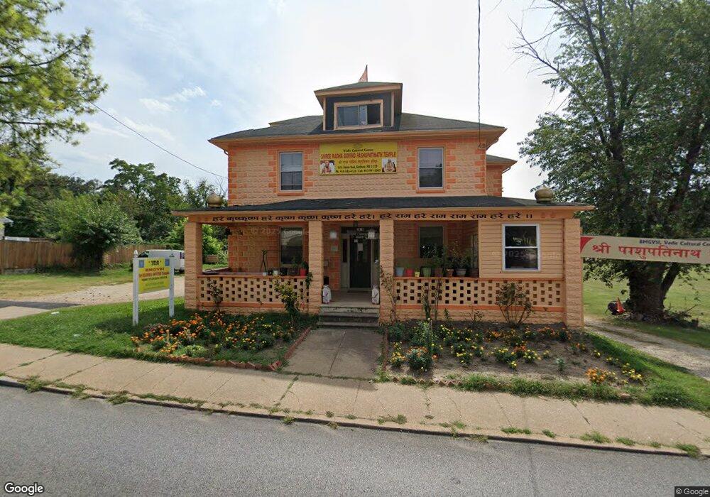
1616 Desoto Rd Baltimore, MD 21230
Morrell Park NeighborhoodEstimated Value: $290,545 - $343,000
4
Beds
2
Baths
2,392
Sq Ft
$132/Sq Ft
Est. Value
About This Home
This home is located at 1616 Desoto Rd, Baltimore, MD 21230 and is currently estimated at $316,773, approximately $132 per square foot. 1616 Desoto Rd is a home located in Baltimore City with nearby schools including Morrell Park Elementary/Middle School, Booker T. Washington Middle School, and Digital Harbor High School.
Ownership History
Date
Name
Owned For
Owner Type
Purchase Details
Closed on
Mar 11, 2010
Sold by
Knight William O
Bought by
Das Srivash
Current Estimated Value
Home Financials for this Owner
Home Financials are based on the most recent Mortgage that was taken out on this home.
Original Mortgage
$164,000
Interest Rate
4.71%
Mortgage Type
New Conventional
Purchase Details
Closed on
Mar 10, 1998
Sold by
William O Knight Wf
Bought by
Knight William O and Knight Joann
Create a Home Valuation Report for This Property
The Home Valuation Report is an in-depth analysis detailing your home's value as well as a comparison with similar homes in the area
Home Values in the Area
Average Home Value in this Area
Purchase History
| Date | Buyer | Sale Price | Title Company |
|---|---|---|---|
| Das Srivash | $205,000 | -- | |
| Knight William O | -- | -- |
Source: Public Records
Mortgage History
| Date | Status | Borrower | Loan Amount |
|---|---|---|---|
| Closed | Das Srivash | $164,000 |
Source: Public Records
Tax History
| Year | Tax Paid | Tax Assessment Tax Assessment Total Assessment is a certain percentage of the fair market value that is determined by local assessors to be the total taxable value of land and additions on the property. | Land | Improvement |
|---|---|---|---|---|
| 2025 | $4,397 | $229,200 | -- | -- |
| 2024 | $4,397 | $213,800 | -- | -- |
| 2023 | $4,311 | $198,400 | $67,500 | $130,900 |
| 2022 | $4,242 | $195,100 | $0 | $0 |
| 2021 | $4,526 | $191,800 | $0 | $0 |
| 2020 | $4,106 | $188,500 | $67,500 | $121,000 |
| 2019 | $4,085 | $188,500 | $67,500 | $121,000 |
| 2018 | $4,146 | $188,500 | $67,500 | $121,000 |
| 2017 | $4,364 | $201,800 | $0 | $0 |
| 2016 | -- | $192,933 | $0 | $0 |
| 2015 | $4,459 | $184,067 | $0 | $0 |
| 2014 | $4,459 | $175,200 | $0 | $0 |
Source: Public Records
Map
Nearby Homes
- 1710 Wickes Ave
- 1803 Casadel Ave
- 2809 Washington Blvd
- 1918 Parksley Ave
- 1707 Morrell Park Ave
- 1704 Harman Ave
- 2506 Washington Blvd
- 1707 Harman Ave
- 2453 Washington Blvd
- 1706 Sexton St
- 1909 Harman Ave
- 2036 Deering Ave
- 1920 Maudlin Ave
- 1933 Grinnalds Ave
- 1935 Grinnalds Ave
- 1918 Griffis Ave
- 2104 Whistler Ave
- 1703 - 1707 1/2 Spence St
- 1933 Griffis Ave
- 1637 Spence St
- 1618 Desoto Rd
- 1620 Desoto Rd
- 1617 Desoto Rd
- 1621 Desoto Rd
- 1700 Desoto Rd
- 1623 Desoto Rd
- 1701 Wickes Ave
- 1704 Desoto Rd
- 1601 Desoto Rd
- 1701 Desoto Rd
- 1703 Desoto Rd
- 1600 Desoto Rd
- 1705 Desoto Rd
- 1708 Desoto Rd
- 1706 Wilmington Ave
- 1707 Desoto Rd
- 1708 Wilmington Ave
- 1705 Wickes Ave
- 1712 Wilmington Ave
- 1710 Desoto Rd
Your Personal Tour Guide
Ask me questions while you tour the home.