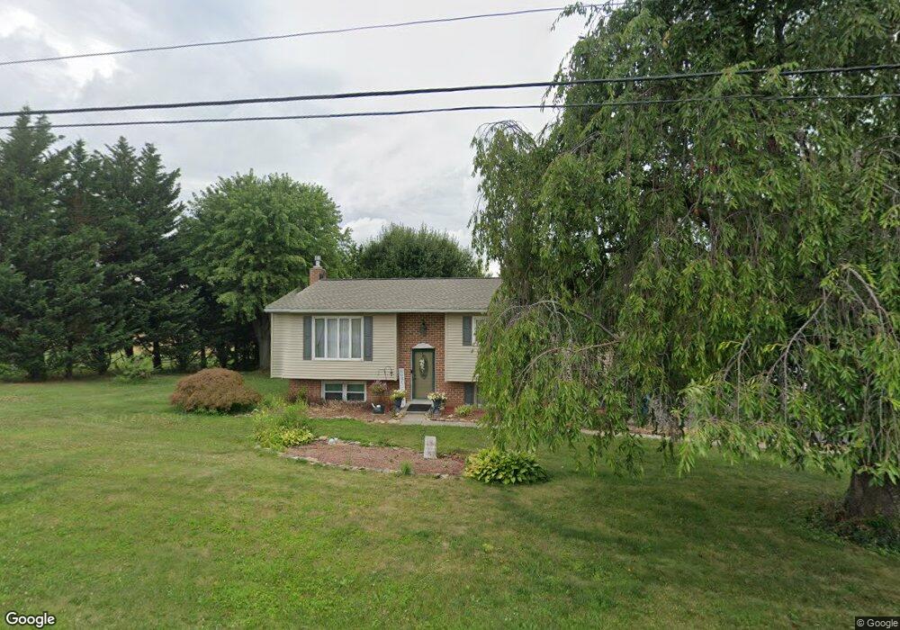
1616 Haar Rd Spring Grove, PA 17362
Estimated Value: $244,000 - $387,000
3
Beds
1
Bath
2,522
Sq Ft
$122/Sq Ft
Est. Value
About This Home
This home is located at 1616 Haar Rd, Spring Grove, PA 17362 and is currently estimated at $308,445, approximately $122 per square foot. 1616 Haar Rd is a home located in York County with nearby schools including Spring Grove Area Middle School, Spring Grove Area High School, and Garbers Mennonite School.
Ownership History
Date
Name
Owned For
Owner Type
Purchase Details
Closed on
Sep 9, 2011
Sold by
Miner Steven K and Miner Darlene M
Bought by
Riser Joseph B and Riser Nicole L
Current Estimated Value
Home Financials for this Owner
Home Financials are based on the most recent Mortgage that was taken out on this home.
Original Mortgage
$165,592
Outstanding Balance
$113,342
Interest Rate
4.25%
Mortgage Type
FHA
Estimated Equity
$195,103
Purchase Details
Closed on
Nov 5, 2003
Sold by
Miner Steven K and Miner Cynthia J
Bought by
Banyon Investment Group Inc
Purchase Details
Closed on
Jun 11, 1976
Bought by
Miner Steven K and Miner Darlene M
Create a Home Valuation Report for This Property
The Home Valuation Report is an in-depth analysis detailing your home's value as well as a comparison with similar homes in the area
Home Values in the Area
Average Home Value in this Area
Purchase History
| Date | Buyer | Sale Price | Title Company |
|---|---|---|---|
| Riser Joseph B | $169,900 | None Available | |
| Banyon Investment Group Inc | $38,500 | -- | |
| Miner Steven K | $38,000 | -- |
Source: Public Records
Mortgage History
| Date | Status | Borrower | Loan Amount |
|---|---|---|---|
| Open | Riser Joseph B | $165,592 |
Source: Public Records
Tax History
| Year | Tax Paid | Tax Assessment Tax Assessment Total Assessment is a certain percentage of the fair market value that is determined by local assessors to be the total taxable value of land and additions on the property. | Land | Improvement |
|---|---|---|---|---|
| 2025 | $4,163 | $124,810 | $30,260 | $94,550 |
| 2024 | $4,118 | $124,810 | $30,260 | $94,550 |
| 2023 | $4,118 | $124,810 | $30,260 | $94,550 |
| 2022 | $4,118 | $124,810 | $30,260 | $94,550 |
| 2021 | $3,940 | $124,810 | $30,260 | $94,550 |
| 2020 | $3,940 | $124,810 | $30,260 | $94,550 |
| 2019 | $3,911 | $124,810 | $30,260 | $94,550 |
| 2018 | $3,860 | $124,810 | $30,260 | $94,550 |
| 2017 | $3,772 | $124,810 | $30,260 | $94,550 |
| 2016 | $0 | $124,810 | $30,260 | $94,550 |
| 2015 | -- | $124,810 | $30,260 | $94,550 |
| 2014 | -- | $124,810 | $30,260 | $94,550 |
Source: Public Records
Map
Nearby Homes
- 798 Menges Mills Rd
- Lot #2 Midhill Rd
- Lot #3 Midhill Rd
- Lot #1 Midhill Rd
- 1063 Porters Rd
- 1934 Forge Heights Ln
- 5493 Lehman Rd
- 6 N Water St
- 360 N Main St
- 174 Springhouse Ln
- 6152 Pigeon Hill Rd
- 5738 Pigeon Hill Rd
- 6308 Liam Dr
- 6309 Liam Dr
- 6310 Liam Dr
- 6083 Jennifer Ln
- 6328 Liam Dr Unit Lot 48
- 6328 Liam Dr
- 0 Sassafras Plan at Hills at Valley View Unit PAYK2097106
- 0 Sugar Maple Plan at Hills at Valley View Unit PAYK2097108
- 1624 Haar Rd
- 5872 Ambau Rd
- 1608 Haar Rd
- 1621 Haar Rd
- 1629 Haar Rd
- 5878 Ambau Rd
- 1613 Haar Rd
- 1632 Haar Rd
- 1639 Haar Rd
- 5867 Ambau Rd
- 0 Ambau Rd Unit 1000462704
- 0 Ambau Rd Unit 1006619788
- 0 Ambau Rd Unit YK10224765
- 0 Ambau Rd Unit 21708800
- 0 Ambau Rd Unit PAYK2000343
- 0 Ambau Rd Unit PAYK127110
- 0 Ambau Rd Unit 1002671799
- 0 Ambau Rd Unit 1009911604
- 0 Ambau Rd Unit 1009002174
- 5858 Ambau Rd
Your Personal Tour Guide
Ask me questions while you tour the home.