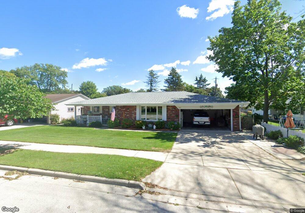
1617 Frank St Green Bay, WI 54304
Lombardi NeighborhoodEstimated Value: $314,198 - $346,000
3
Beds
2
Baths
1,472
Sq Ft
$224/Sq Ft
Est. Value
About This Home
This home is located at 1617 Frank St, Green Bay, WI 54304 and is currently estimated at $329,300, approximately $223 per square foot. 1617 Frank St is a home located in Brown County with nearby schools including Jackson Elementary School, Franklin Middle School, and West High School.
Ownership History
Date
Name
Owned For
Owner Type
Purchase Details
Closed on
Sep 30, 2014
Sold by
Ferguson Robert H
Bought by
Hanna Dawn M
Current Estimated Value
Purchase Details
Closed on
Feb 25, 2008
Sold by
Lemorande Alice E
Bought by
Ferguson Robert H and Ferguson Judith A
Home Financials for this Owner
Home Financials are based on the most recent Mortgage that was taken out on this home.
Original Mortgage
$96,000
Outstanding Balance
$58,217
Interest Rate
5.25%
Mortgage Type
Purchase Money Mortgage
Estimated Equity
$271,083
Create a Home Valuation Report for This Property
The Home Valuation Report is an in-depth analysis detailing your home's value as well as a comparison with similar homes in the area
Home Values in the Area
Average Home Value in this Area
Purchase History
| Date | Buyer | Sale Price | Title Company |
|---|---|---|---|
| Hanna Dawn M | -- | -- | |
| Ferguson Robert H | $120,000 | Bay Title & Abstract Inc |
Source: Public Records
Mortgage History
| Date | Status | Borrower | Loan Amount |
|---|---|---|---|
| Open | Ferguson Robert H | $96,000 |
Source: Public Records
Tax History Compared to Growth
Tax History
| Year | Tax Paid | Tax Assessment Tax Assessment Total Assessment is a certain percentage of the fair market value that is determined by local assessors to be the total taxable value of land and additions on the property. | Land | Improvement |
|---|---|---|---|---|
| 2024 | $3,806 | $205,800 | $50,000 | $155,800 |
| 2023 | $3,629 | $205,800 | $50,000 | $155,800 |
| 2022 | $3,553 | $205,800 | $50,000 | $155,800 |
| 2021 | $2,775 | $124,300 | $20,300 | $104,000 |
| 2020 | $2,821 | $124,300 | $20,300 | $104,000 |
| 2019 | $2,725 | $124,300 | $20,300 | $104,000 |
| 2018 | $2,667 | $124,300 | $20,300 | $104,000 |
| 2017 | $2,643 | $124,300 | $20,300 | $104,000 |
| 2016 | $2,600 | $124,300 | $20,300 | $104,000 |
| 2015 | $2,704 | $124,300 | $20,300 | $104,000 |
| 2014 | $2,768 | $124,300 | $20,300 | $104,000 |
| 2013 | $2,768 | $124,300 | $20,300 | $104,000 |
Source: Public Records
Map
Nearby Homes
- 1244 Liberty St
- 1348 Liberty St
- 1428 Beauchamp St
- 1749 S Oneida St Unit 1751
- 1751 S Oneida St
- 1163 Thorndale St
- 1181 Roscoe St
- 1507 Delores St
- 1122 Biemeret St
- 1212 9th St
- 1839 S Oneida St Unit 1845
- 1444 Liberty St
- 1252 Marian Ln
- 1203 Spence St
- 1427 Russell St
- 1110 Roscoe St
- 1100 Brookwood Dr
- 1110 Brookwood Dr
- 1500 S Fisk St
- 1077 Brookwood Dr
- 1611 Frank St
- 1270 Liberty St Unit 1272
- 1616 Walls St Unit 1618
- 1610 Walls St
- 1262 Liberty St Unit 1266
- 1605 Frank St
- 1616 Frank St
- 1604 Walls St
- 1284 Liberty St Unit 1286
- 1284 Liberty St
- 1610 Frank St
- 1601 Frank St
- 1703 Frank St
- 1604 Frank St
- 1600 Walls St
- 1267 Liberty St
- 1261 Liberty St
- 1285 Liberty St
- 1600 Frank St
- 1615 Walls St