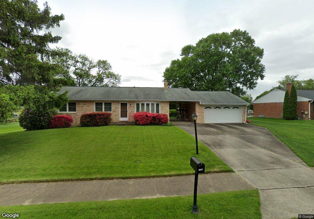
1617 Ruger Dr Bel Air, MD 21015
Estimated Value: $389,664 - $451,000
--
Bed
1
Bath
1,276
Sq Ft
$331/Sq Ft
Est. Value
About This Home
This home is located at 1617 Ruger Dr, Bel Air, MD 21015 and is currently estimated at $422,416, approximately $331 per square foot. 1617 Ruger Dr is a home located in Harford County with nearby schools including Fountain Green Elementary School, Southampton Middle School, and C. Milton Wright High School.
Ownership History
Date
Name
Owned For
Owner Type
Purchase Details
Closed on
Oct 29, 1990
Sold by
Kuzan John David
Bought by
Lukens Larry K
Current Estimated Value
Home Financials for this Owner
Home Financials are based on the most recent Mortgage that was taken out on this home.
Original Mortgage
$32,000
Interest Rate
10.17%
Purchase Details
Closed on
Apr 14, 1989
Sold by
Wieners Charles W and Wieners Wf
Bought by
Kuzan John David
Home Financials for this Owner
Home Financials are based on the most recent Mortgage that was taken out on this home.
Original Mortgage
$133,300
Interest Rate
11.11%
Create a Home Valuation Report for This Property
The Home Valuation Report is an in-depth analysis detailing your home's value as well as a comparison with similar homes in the area
Home Values in the Area
Average Home Value in this Area
Purchase History
| Date | Buyer | Sale Price | Title Company |
|---|---|---|---|
| Lukens Larry K | $134,000 | -- | |
| Kuzan John David | $132,000 | -- |
Source: Public Records
Mortgage History
| Date | Status | Borrower | Loan Amount |
|---|---|---|---|
| Closed | Lukens Larry K | $32,000 | |
| Previous Owner | Kuzan John David | $133,300 |
Source: Public Records
Tax History Compared to Growth
Tax History
| Year | Tax Paid | Tax Assessment Tax Assessment Total Assessment is a certain percentage of the fair market value that is determined by local assessors to be the total taxable value of land and additions on the property. | Land | Improvement |
|---|---|---|---|---|
| 2025 | $3,391 | $326,400 | $98,700 | $227,700 |
| 2024 | $3,391 | $311,133 | $0 | $0 |
| 2023 | $3,295 | $302,333 | $0 | $0 |
| 2022 | $3,123 | $286,500 | $98,700 | $187,800 |
| 2021 | $3,130 | $278,867 | $0 | $0 |
| 2020 | $3,130 | $271,233 | $0 | $0 |
| 2019 | $3,042 | $263,600 | $113,100 | $150,500 |
| 2018 | $2,947 | $257,700 | $0 | $0 |
| 2017 | $2,880 | $263,600 | $0 | $0 |
| 2016 | -- | $245,900 | $0 | $0 |
| 2015 | $2,865 | $245,900 | $0 | $0 |
| 2014 | $2,865 | $245,900 | $0 | $0 |
Source: Public Records
Map
Nearby Homes
- 1622 Shady Tree Ct
- 1620 Shady Tree Ct
- 1618 Shady Tree Ct
- 1614 Shady Tree Ct
- 1612 Shady Tree Ct
- 1619 Shady Tree Ct
- 1617 Shady Tree Ct
- 1613 Shady Tree Ct
- 1609 Shady Tree Ct
- 1607 Shady Tree Ct
- 1605 Shady Tree Ct
- Yorktown Plan at Roberts Crossing
- Coronado Plan at Roberts Crossing
- Hemingway Plan at Roberts Crossing
- 602 Flintlock Dr
- 1505 Southview Rd
- 1441 Valbrook Ct N
- 1453 Redfield Rd
- 1358 Merry Hill Ct
- 1313 Kelsey Ct