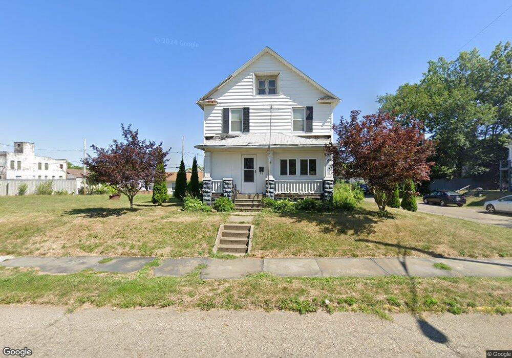
162 11th St Alliance, OH 44601
Estimated Value: $74,000 - $101,000
3
Beds
1
Bath
1,440
Sq Ft
$60/Sq Ft
Est. Value
About This Home
This home is located at 162 11th St, Alliance, OH 44601 and is currently estimated at $86,521, approximately $60 per square foot. 162 11th St is a home located in Stark County with nearby schools including Alliance Elementary School at Rockhill, Alliance Intermediate School at Northside, and Alliance Middle School.
Ownership History
Date
Name
Owned For
Owner Type
Purchase Details
Closed on
Jan 18, 2007
Sold by
Yanik Nicole M
Bought by
Landwert Michael and Landwert Alice
Current Estimated Value
Home Financials for this Owner
Home Financials are based on the most recent Mortgage that was taken out on this home.
Original Mortgage
$48,000
Outstanding Balance
$28,685
Interest Rate
6.21%
Mortgage Type
Purchase Money Mortgage
Estimated Equity
$57,836
Purchase Details
Closed on
Jul 8, 2004
Sold by
Federal Home Loan Mortgage Corporation
Bought by
Yanik Nicole M
Home Financials for this Owner
Home Financials are based on the most recent Mortgage that was taken out on this home.
Original Mortgage
$37,050
Interest Rate
6.34%
Mortgage Type
New Conventional
Purchase Details
Closed on
Jan 12, 2004
Sold by
Gordon Larry D and Gordon Tracy L
Bought by
Federal Home Loan Mortgage Corporation
Purchase Details
Closed on
Jan 8, 1999
Sold by
Rogers Neil and Rogers Crystal J
Bought by
Gordon Larry and Gordon Tracy L
Home Financials for this Owner
Home Financials are based on the most recent Mortgage that was taken out on this home.
Original Mortgage
$57,000
Interest Rate
9.81%
Mortgage Type
Purchase Money Mortgage
Purchase Details
Closed on
Aug 30, 1990
Create a Home Valuation Report for This Property
The Home Valuation Report is an in-depth analysis detailing your home's value as well as a comparison with similar homes in the area
Home Values in the Area
Average Home Value in this Area
Purchase History
| Date | Buyer | Sale Price | Title Company |
|---|---|---|---|
| Landwert Michael | $48,000 | Attorney | |
| Yanik Nicole M | $39,000 | -- | |
| Federal Home Loan Mortgage Corporation | $32,000 | -- | |
| Gordon Larry | $60,000 | -- | |
| -- | $31,000 | -- |
Source: Public Records
Mortgage History
| Date | Status | Borrower | Loan Amount |
|---|---|---|---|
| Open | Landwert Michael | $48,000 | |
| Closed | Yanik Nicole M | $37,050 | |
| Previous Owner | Gordon Larry | $57,000 |
Source: Public Records
Tax History
| Year | Tax Paid | Tax Assessment Tax Assessment Total Assessment is a certain percentage of the fair market value that is determined by local assessors to be the total taxable value of land and additions on the property. | Land | Improvement |
|---|---|---|---|---|
| 2025 | -- | $20,860 | $3,850 | $17,010 |
| 2024 | -- | $20,860 | $3,850 | $17,010 |
| 2023 | $514 | $12,780 | $3,780 | $9,000 |
| 2022 | $517 | $12,780 | $3,780 | $9,000 |
| 2021 | $517 | $12,780 | $3,780 | $9,000 |
| 2020 | $518 | $11,940 | $3,290 | $8,650 |
| 2019 | $510 | $11,940 | $3,290 | $8,650 |
Source: Public Records
Map
Nearby Homes
- 167 11th St
- 134 11th St
- 226 Milner St
- 231 Rosenberry St
- 234 Rosenberry St
- 46 Rosenberry St
- 233 Shadyside Ct
- 1350 S Freedom Ave
- 807 S Union Ave
- 726 S Arch Ave
- 452 E Summit St
- 203 Glamorgan St
- 1608 S Liberty Ave
- 935 S Morgan Ave
- 834 Devine St
- 0 E Oxford St
- 427 S Union Ave
- 62 E High St
- 621 S Haines Ave
- 1823 S Seneca Ave
Your Personal Tour Guide
Ask me questions while you tour the home.