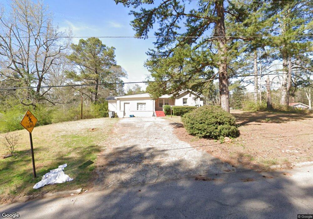
162 Alton Dr Lagrange, GA 30241
Estimated Value: $205,057 - $227,000
4
Beds
2
Baths
1,684
Sq Ft
$128/Sq Ft
Est. Value
About This Home
This home is located at 162 Alton Dr, Lagrange, GA 30241 and is currently estimated at $215,514, approximately $127 per square foot. 162 Alton Dr is a home located in Troup County with nearby schools including Franklin Forest Elementary School, Hollis Hand Elementary School, and Ethel W. Kight Elementary School.
Ownership History
Date
Name
Owned For
Owner Type
Purchase Details
Closed on
Aug 30, 2011
Sold by
Secretary Of Housing
Bought by
Edelson Stephen
Current Estimated Value
Purchase Details
Closed on
Jun 25, 2010
Sold by
Wells Fargo Bank Na
Bought by
Secretary Of Housing
Purchase Details
Closed on
Nov 3, 2001
Sold by
Angela Louis and Angela Barnett
Bought by
Rowland Angela
Purchase Details
Closed on
Aug 3, 2000
Sold by
Gill Frank
Bought by
Angela Louis and Angela Barnett
Purchase Details
Closed on
Mar 13, 1995
Sold by
Richard Smallwood
Bought by
Gill Frank
Purchase Details
Closed on
Oct 1, 1982
Sold by
Tanner Harry E and Tanner Virginia E
Bought by
Richard Smallwood
Purchase Details
Closed on
Mar 12, 1976
Sold by
Bass Norman
Bought by
Tanner Harry E and Tanner Virginia E
Purchase Details
Closed on
Feb 1, 1970
Sold by
Kemp George W
Bought by
Bass Norman
Purchase Details
Closed on
Nov 1, 1965
Sold by
Dagenhart Donald Ray and Dagenhart Nancy B
Bought by
Kemp George W
Create a Home Valuation Report for This Property
The Home Valuation Report is an in-depth analysis detailing your home's value as well as a comparison with similar homes in the area
Purchase History
| Date | Buyer | Sale Price | Title Company |
|---|---|---|---|
| Edelson Stephen | $25,050 | -- | |
| Secretary Of Housing | $78,395 | -- | |
| Rowland Angela | $81,900 | -- | |
| Angela Louis | $147,000 | -- | |
| Gill Frank | $53,000 | -- | |
| Richard Smallwood | $14,900 | -- | |
| Tanner Harry E | $21,800 | -- | |
| Bass Norman | $3,500 | -- | |
| Kemp George W | -- | -- |
Source: Public Records
Tax History
| Year | Tax Paid | Tax Assessment Tax Assessment Total Assessment is a certain percentage of the fair market value that is determined by local assessors to be the total taxable value of land and additions on the property. | Land | Improvement |
|---|---|---|---|---|
| 2025 | $1,868 | $68,480 | $10,000 | $58,480 |
| 2024 | $1,589 | $58,280 | $10,000 | $48,280 |
| 2023 | $1,444 | $52,960 | $10,000 | $42,960 |
| 2022 | $1,404 | $50,320 | $10,000 | $40,320 |
| 2021 | $1,134 | $37,600 | $8,000 | $29,600 |
| 2020 | $1,134 | $37,600 | $8,000 | $29,600 |
| 2019 | $1,034 | $34,280 | $7,520 | $26,760 |
| 2018 | $977 | $32,400 | $7,200 | $25,200 |
| 2017 | $977 | $32,400 | $7,200 | $25,200 |
| 2016 | $951 | $31,528 | $7,200 | $24,328 |
| 2015 | $884 | $29,255 | $7,546 | $21,710 |
| 2014 | $851 | $28,112 | $7,546 | $20,567 |
| 2013 | -- | $29,987 | $7,546 | $22,441 |
Source: Public Records
Map
Nearby Homes
- 114 Briarcliff Rd
- 806 New Franklin Rd
- 202 Park Hill Dr
- 102 Dogwood Dr
- 204 Colonial St
- 110 Russell St
- 900 North St
- 134 S Page St
- 203 Bonaventure Dr
- 210 Hearthstone Dr
- 224 Rutland Cir
- 706 N Harlem Cir
- 109 Thomas St
- 219 Banks St
- 616 S Harlem Cir
- 131 Foch St
- 87 Youngs Mill Rd
- 106 Ewing St
- 222 Beechwood Cir
- 0 Ridley Ave Unit 10550104
- 160 Alton Dr
- 168 Merrybrook Dr
- 208 Merrybrook Dr
- 204 Merrybrook Dr
- 165 Alton Dr
- 156 Alton Dr
- 161 Alton Dr
- 153 Cascade Cir
- 170 Merrybrook Dr
- 201 Alton Dr
- 201 Alton Dr
- 210 Merrybrook Dr
- 202 Merrybrook Dr
- 157 Alton Dr
- 154 Alton Dr
- 155 Cascade Cir
- 301 Merrybrook Dr
- 172 Merrybrook Dr
- 300 Merrybrook Dr
- 151 Alton Dr
Your Personal Tour Guide
Ask me questions while you tour the home.