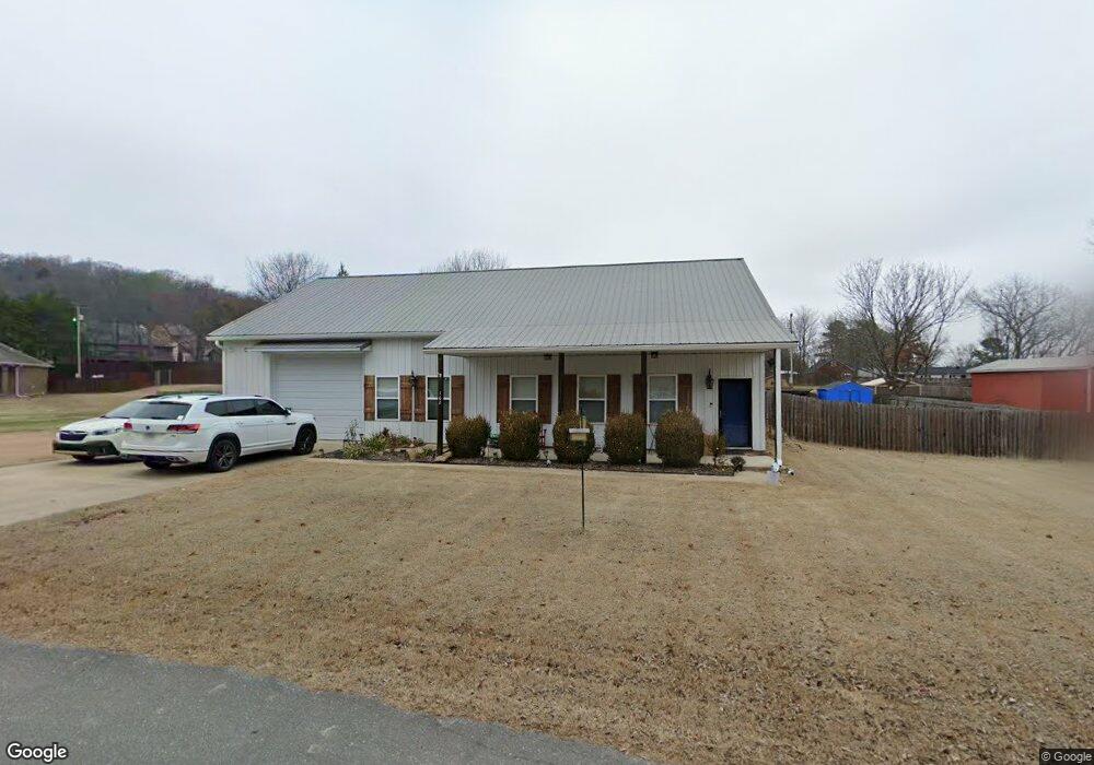
162 Bullard Rd West Fork, AR 72774
Estimated Value: $278,000 - $354,000
--
Bed
--
Bath
1,920
Sq Ft
$158/Sq Ft
Est. Value
About This Home
This home is located at 162 Bullard Rd, West Fork, AR 72774 and is currently estimated at $303,481, approximately $158 per square foot. 162 Bullard Rd is a home with nearby schools including West Fork Elementary School, West Fork Middle School, and West Fork High School.
Ownership History
Date
Name
Owned For
Owner Type
Purchase Details
Closed on
Aug 14, 2017
Sold by
Hammons Mike and Hammons Heather
Bought by
Firth Philip D and Firth Heather J
Current Estimated Value
Home Financials for this Owner
Home Financials are based on the most recent Mortgage that was taken out on this home.
Original Mortgage
$144,000
Outstanding Balance
$119,869
Interest Rate
3.96%
Mortgage Type
New Conventional
Estimated Equity
$183,612
Purchase Details
Closed on
Apr 24, 2014
Sold by
Hm Properties Inc
Bought by
Hammons Mike and Hammons Heather
Create a Home Valuation Report for This Property
The Home Valuation Report is an in-depth analysis detailing your home's value as well as a comparison with similar homes in the area
Home Values in the Area
Average Home Value in this Area
Purchase History
| Date | Buyer | Sale Price | Title Company |
|---|---|---|---|
| Firth Philip D | $180,000 | None Available | |
| Hammons Mike | $17,500 | Waco Title Co |
Source: Public Records
Mortgage History
| Date | Status | Borrower | Loan Amount |
|---|---|---|---|
| Open | Firth Philip D | $144,000 |
Source: Public Records
Tax History Compared to Growth
Tax History
| Year | Tax Paid | Tax Assessment Tax Assessment Total Assessment is a certain percentage of the fair market value that is determined by local assessors to be the total taxable value of land and additions on the property. | Land | Improvement |
|---|---|---|---|---|
| 2025 | $968 | $41,510 | $9,000 | $32,510 |
| 2024 | $997 | $41,510 | $9,000 | $32,510 |
| 2023 | $1,012 | $41,510 | $9,000 | $32,510 |
| 2022 | $994 | $30,440 | $4,500 | $25,940 |
| 2021 | $934 | $30,440 | $4,500 | $25,940 |
| 2020 | $875 | $30,440 | $4,500 | $25,940 |
| 2019 | $815 | $22,410 | $4,000 | $18,410 |
| 2018 | $840 | $22,410 | $4,000 | $18,410 |
| 2017 | $806 | $22,410 | $4,000 | $18,410 |
| 2016 | $806 | $22,410 | $4,000 | $18,410 |
| 2015 | $806 | $22,410 | $4,000 | $18,410 |
| 2014 | $206 | $4,590 | $4,590 | $0 |
Source: Public Records
Map
Nearby Homes
- 696 E Thornstone Ave
- 260 Culp Trail
- 222 Rivendale Dr
- 503 Clark Ave
- 497 Clark Ave
- 378 Hidden Creek Place
- Springs 1445 Plan at Rolling Plains
- Eureka 1536 Plan at Rolling Plains
- Oak 1463 Plan at Rolling Plains
- Magnolia 1556 Plan at Rolling Plains
- Ashton 1496 Plan at Rolling Plains
- Ouachita 1669 Plan at Rolling Plains
- Osage 1567 Plan at Rolling Plains
- Maple 1659 Plan at Rolling Plains
- 340 W Smith St
- 393 W Smith St
- 365 W Smith St
- 359 W Smith St
- 339 W Smith St
- 327 W Smith St
- 699 Mcknight Ave
- 715 Mcknight Ave
- 176 Bullard Rd
- Lot 2 Bullard Rd
- 691 Mcknight Ave
- 727 Mcknight Ave
- 0 Lot 1 Bullard Rd Unit 670326
- 716 E Thornstone Ave
- 686 E Thornstone Ave
- 708 E Thornstone Ave
- 135 Graystone St
- 735 Mcknight Ave
- 673 Mcknight Ave
- 151 Graystone St
- 0 E Thornstone Ave Unit 526537
- 0 E Thornstone Ave Unit 526539
- 0 E Thornstone Ave Unit 526542
- 0 E Thornstone Ave Unit 562527
- 0 E Thornstone Ave Unit 562528
- 0 Thornstone Ave Unit 562531