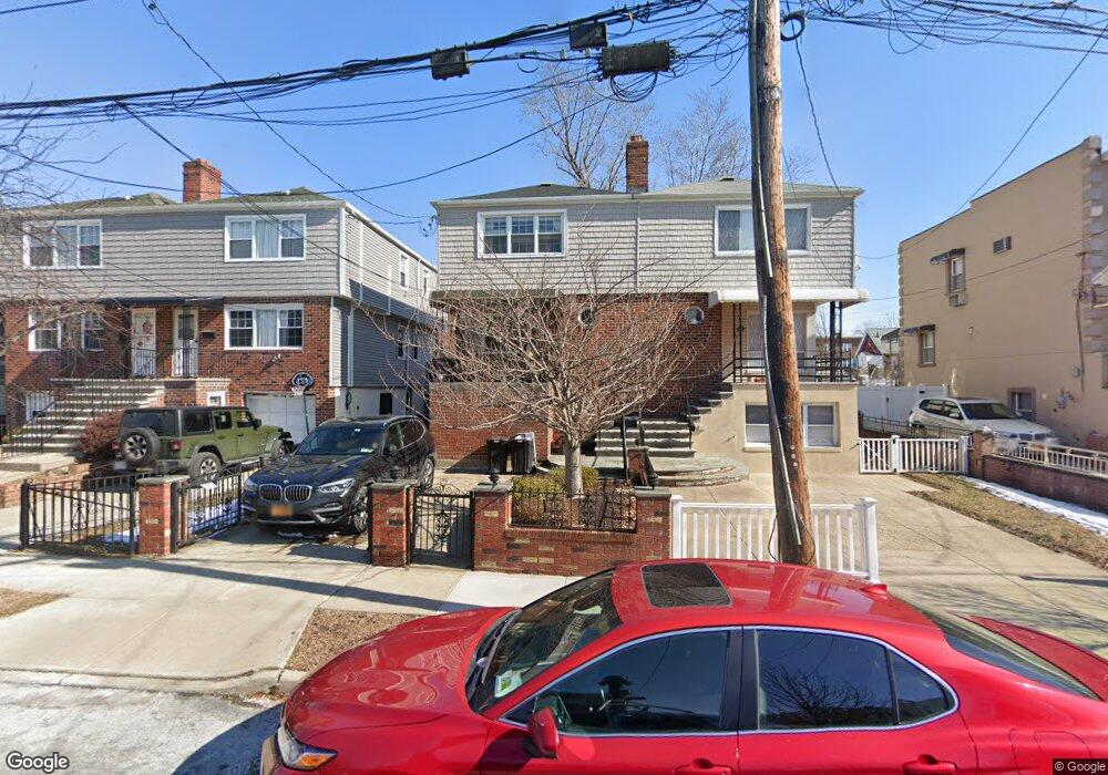
162 Calhoun Ave Bronx, NY 10465
Throgs Neck-Edgewater Park NeighborhoodEstimated Value: $609,586 - $753,000
--
Bed
--
Bath
1,992
Sq Ft
$346/Sq Ft
Est. Value
About This Home
This home is located at 162 Calhoun Ave, Bronx, NY 10465 and is currently estimated at $689,647, approximately $346 per square foot. 162 Calhoun Ave is a home located in Bronx County with nearby schools including P.S. 72 - Dr. William Dorney, Herbert H Lehman High School, and St. Frances de Chantal School.
Ownership History
Date
Name
Owned For
Owner Type
Purchase Details
Closed on
Oct 1, 2013
Sold by
Rivera Robert W
Bought by
Rodriguez Marie A
Current Estimated Value
Purchase Details
Closed on
Feb 1, 2002
Sold by
Mccarthy Melissa Heir and Matarazzo Mary Est Of
Bought by
Rivera Robert W and Rodriguez-Rivera Marie
Home Financials for this Owner
Home Financials are based on the most recent Mortgage that was taken out on this home.
Original Mortgage
$240,000
Interest Rate
7.18%
Create a Home Valuation Report for This Property
The Home Valuation Report is an in-depth analysis detailing your home's value as well as a comparison with similar homes in the area
Home Values in the Area
Average Home Value in this Area
Purchase History
| Date | Buyer | Sale Price | Title Company |
|---|---|---|---|
| Rodriguez Marie A | -- | -- | |
| Rivera Robert W | -- | -- |
Source: Public Records
Mortgage History
| Date | Status | Borrower | Loan Amount |
|---|---|---|---|
| Previous Owner | Rivera Robert W | $240,000 |
Source: Public Records
Tax History Compared to Growth
Tax History
| Year | Tax Paid | Tax Assessment Tax Assessment Total Assessment is a certain percentage of the fair market value that is determined by local assessors to be the total taxable value of land and additions on the property. | Land | Improvement |
|---|---|---|---|---|
| 2025 | $5,954 | $31,277 | $6,960 | $24,317 |
| 2024 | $5,954 | $31,042 | $7,254 | $23,788 |
| 2023 | $5,663 | $29,285 | $6,086 | $23,199 |
| 2022 | $5,228 | $39,780 | $9,240 | $30,540 |
| 2021 | $5,182 | $37,020 | $9,240 | $27,780 |
| 2020 | $5,221 | $35,820 | $9,240 | $26,580 |
| 2019 | $5,118 | $33,240 | $9,240 | $24,000 |
| 2018 | $4,677 | $24,404 | $7,996 | $16,408 |
| 2017 | $4,394 | $23,023 | $8,711 | $14,312 |
| 2016 | $4,032 | $21,720 | $9,240 | $12,480 |
| 2015 | $3,018 | $24,600 | $10,260 | $14,340 |
| 2014 | $3,018 | $24,600 | $10,260 | $14,340 |
Source: Public Records
Map
Nearby Homes
- 2834 Harding Ave
- 2832 Harding Ave
- 2819 Collis Place
- 166 Revere Ave
- 149 Revere Ave
- 2819 Schurz Ave
- 4246 E Tremont Ave Unit MF
- 180 Swinton Ave
- 235 Quincy Ave
- 244 Revere Ave
- 238 Swinton Ave
- 189 Swinton Ave
- 2857 Lawton Ave
- 266 Swinton Ave
- 283 Calhoun Ave
- 2730 Schurz Ave Unit N3 & N4
- 2973 Harding Ave
- 2737 Lawton Ave
- 329 Revere Ave
- 310 Huntington Ave
- 164 Calhoun Ave
- 160 Calhoun Ave
- 166 Calhoun Ave
- 156 Calhoun Ave
- 168 Calhoun Ave
- 154 Calhoun Ave
- 152 Calhoun Ave
- 170 Calhoun Ave Unit 1
- 170 Calhoun Ave
- 159 Revere Ave
- 157 Revere Ave
- 161 Revere Ave
- 155 Revere Ave
- 163 Revere Ave
- 157 Revere Ave
- 165 Revere Ave
- 172 Calhoun Ave
- 2829 Schurz Ave
- 167 Revere Ave
- 161 Calhoun Ave