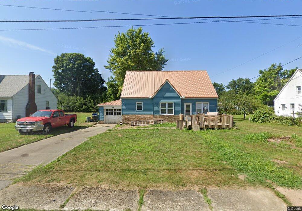
162 High St Cochranton, PA 16314
Estimated Value: $42,000 - $116,000
Studio
--
Bath
--
Sq Ft
12,720
Sq Ft Lot
About This Home
This home is located at 162 High St, Cochranton, PA 16314 and is currently estimated at $79,375. 162 High St is a home located in Crawford County with nearby schools including Cochranton Elementary School and Cochranton Junior/Senior High School.
Ownership History
Date
Name
Owned For
Owner Type
Purchase Details
Closed on
Jan 5, 2024
Sold by
Staples David
Bought by
Fleming Daniel and Fleming Abby
Current Estimated Value
Purchase Details
Closed on
Nov 8, 2023
Sold by
Crawford County Trust & Saving
Bought by
Staples David
Purchase Details
Closed on
Oct 26, 2007
Sold by
Wells Fargo Bank Na
Bought by
Pontius Christopher L
Home Financials for this Owner
Home Financials are based on the most recent Mortgage that was taken out on this home.
Original Mortgage
$43,600
Interest Rate
6.43%
Mortgage Type
Purchase Money Mortgage
Create a Home Valuation Report for This Property
The Home Valuation Report is an in-depth analysis detailing your home's value as well as a comparison with similar homes in the area
Purchase History
| Date | Buyer | Sale Price | Title Company |
|---|---|---|---|
| Fleming Daniel | $45,000 | None Listed On Document | |
| Staples David | $34,000 | None Listed On Document | |
| Pontius Christopher L | $42,500 | None Available |
Source: Public Records
Mortgage History
| Date | Status | Borrower | Loan Amount |
|---|---|---|---|
| Previous Owner | Pontius Christopher L | $43,600 |
Source: Public Records
Tax History
| Year | Tax Paid | Tax Assessment Tax Assessment Total Assessment is a certain percentage of the fair market value that is determined by local assessors to be the total taxable value of land and additions on the property. | Land | Improvement |
|---|---|---|---|---|
| 2025 | $754 | $20,900 | $2,700 | $18,200 |
| 2024 | $1,026 | $20,900 | $2,700 | $18,200 |
| 2023 | $1,026 | $20,900 | $2,700 | $18,200 |
| 2022 | $1,893 | $20,900 | $2,700 | $18,200 |
| 2021 | $1,854 | $20,900 | $2,700 | $18,200 |
| 2020 | $1,854 | $20,900 | $2,700 | $18,200 |
| 2019 | $1,854 | $20,900 | $2,700 | $18,200 |
| 2018 | $1,776 | $20,900 | $2,700 | $18,200 |
| 2017 | $1,759 | $20,900 | $2,700 | $18,200 |
| 2016 | $691 | $20,900 | $2,700 | $18,200 |
| 2015 | $691 | $20,900 | $2,700 | $18,200 |
| 2014 | -- | $20,900 | $2,700 | $18,200 |
Source: Public Records
Map
Nearby Homes
- 119 W Pine St
- 145 E Adams St
- 162 N Franklin St
- 23755 State Highway 285
- 23078 Mallard Ln
- 1313 New Lebanon Rd
- 7167 Pettis Rd
- 6528 Mccracken Rd
- 21412 Shick Dr
- 6204-017-2 Shick Dr
- 315 Long Rd
- 0 Deckards Run Rd and Judson Rd Unit 11536704
- 4913 Rock Creek Rd
- 410 Chestnut Grove Rd
- 199 Anglers Rest Ln
- 5154 Ashley Dr
- 315 Sunol Rd
- 116 3rd St
- 3857 Academy St
- 175 Phelps Rd
Your Personal Tour Guide
Ask me questions while you tour the home.