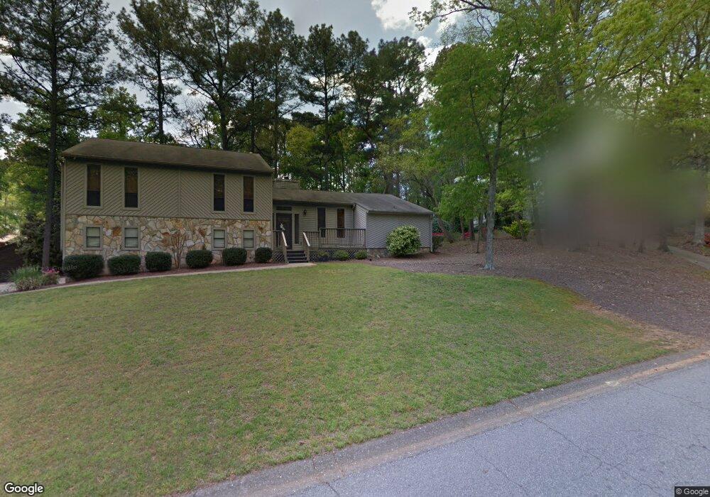
162 Port Patrick Ln SE Mableton, GA 30126
Estimated Value: $344,000 - $354,000
3
Beds
2
Baths
1,716
Sq Ft
$204/Sq Ft
Est. Value
About This Home
This home is located at 162 Port Patrick Ln SE, Mableton, GA 30126 and is currently estimated at $349,420, approximately $203 per square foot. 162 Port Patrick Ln SE is a home located in Cobb County with nearby schools including Mableton Elementary School, Floyd Middle School, and Covered Bridge Academy.
Ownership History
Date
Name
Owned For
Owner Type
Purchase Details
Closed on
Feb 23, 2009
Sold by
Brostrand Roy W and Brostrand Mary
Bought by
Brostrand Mary J
Current Estimated Value
Home Financials for this Owner
Home Financials are based on the most recent Mortgage that was taken out on this home.
Original Mortgage
$219,780
Outstanding Balance
$139,898
Interest Rate
5.15%
Mortgage Type
FHA
Estimated Equity
$209,522
Purchase Details
Closed on
Oct 27, 2000
Sold by
Brostrand Roy W
Bought by
Brostrand Roy W and Brostrand Mary
Home Financials for this Owner
Home Financials are based on the most recent Mortgage that was taken out on this home.
Original Mortgage
$120,700
Interest Rate
7.94%
Mortgage Type
New Conventional
Create a Home Valuation Report for This Property
The Home Valuation Report is an in-depth analysis detailing your home's value as well as a comparison with similar homes in the area
Home Values in the Area
Average Home Value in this Area
Purchase History
| Date | Buyer | Sale Price | Title Company |
|---|---|---|---|
| Brostrand Mary J | -- | -- | |
| Brostrand Roy W | -- | -- |
Source: Public Records
Mortgage History
| Date | Status | Borrower | Loan Amount |
|---|---|---|---|
| Open | Brostrand Mary J | $219,780 | |
| Previous Owner | Brostrand Roy W | $120,700 |
Source: Public Records
Tax History Compared to Growth
Tax History
| Year | Tax Paid | Tax Assessment Tax Assessment Total Assessment is a certain percentage of the fair market value that is determined by local assessors to be the total taxable value of land and additions on the property. | Land | Improvement |
|---|---|---|---|---|
| 2024 | $1,283 | $152,468 | $32,000 | $120,468 |
| 2023 | $1,006 | $128,812 | $24,000 | $104,812 |
| 2022 | $3,269 | $107,712 | $19,200 | $88,512 |
| 2021 | $2,842 | $93,644 | $14,400 | $79,244 |
| 2020 | $2,835 | $93,412 | $14,400 | $79,012 |
| 2019 | $2,339 | $77,064 | $13,600 | $63,464 |
| 2018 | $2,339 | $77,064 | $13,600 | $63,464 |
| 2017 | $1,728 | $60,096 | $13,600 | $46,496 |
| 2016 | $1,728 | $60,096 | $13,600 | $46,496 |
| 2015 | $1,333 | $45,256 | $14,000 | $31,256 |
| 2014 | $1,345 | $45,256 | $0 | $0 |
Source: Public Records
Map
Nearby Homes
- 0 Nickajack Rd SE Unit 7594642
- 4724 Warrior Way SE Unit II
- 387 Nickajack Rd SE
- 51 Queen Anne Dr SE
- 4875 Millen Dr SE
- 4717 Crest Knoll Dr SE
- 4909 Millen Dr SE
- 164 Wana Cir SE
- 162 Wana Cir SE
- 4782 Donnegal Ct SE
- 26 Flint Ridge Dr SE
- 4070 W Cooper Lake Dr SE
- 4094 Norton Place SE
- 71 Anita Place SE
- 476 Cooper Lake Rd SE
- 3910 W Cooper Lake Dr SE
- 4461 Derby Ln SE
- 4730 Sir Walter Ct SE
- 160 Port Patrick Ln SE
- 0 Port Patrick Ln SE Unit 7517925
- 0 Port Patrick Ln SE Unit 7418193
- 0 Port Patrick Ln SE Unit 7363301
- 0 Port Patrick Ln SE Unit 8500340
- 0 Port Patrick Ln SE Unit 8160385
- 0 Port Patrick Ln SE Unit 7366578
- 0 Port Patrick Ln SE Unit 7337393
- 165 Port Patrick Ln SE
- 163 Port Patrick Ln SE
- 0 Nickajack Rd SE Unit 7219190
- 0 Nickajack Rd SE Unit 7114602
- 0 Nickajack Rd SE Unit 7597791
- 0 Nickajack Rd SE Unit 8340690
- 0 Nickajack Rd SE Unit 8419978
- 0 Nickajack Rd SE Unit 7301272
- 0 Nickajack Rd SE
- 4740 Sir Walter Ct SE
- 4715 Balley Shannon Dr SE