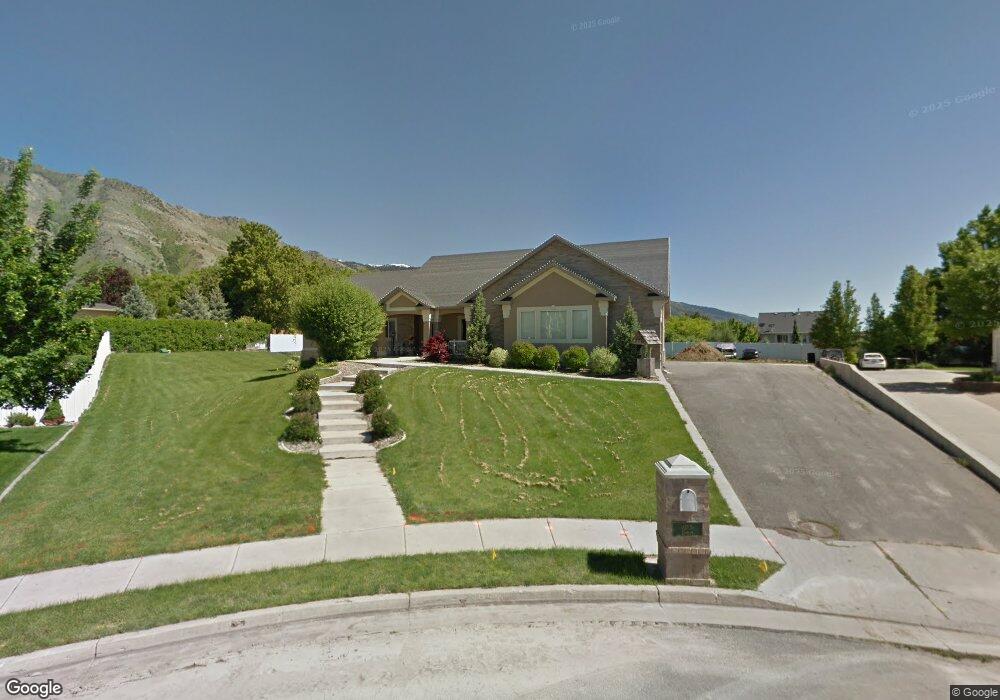
1620 Camelot Dr North Logan, UT 84341
Estimated Value: $738,000 - $843,979
7
Beds
5
Baths
4,655
Sq Ft
$169/Sq Ft
Est. Value
About This Home
This home is located at 1620 Camelot Dr, North Logan, UT 84341 and is currently estimated at $785,495, approximately $168 per square foot. 1620 Camelot Dr is a home located in Cache County with nearby schools including Greenville School, Cedar Ridge School, and Cedar Ridge Middle School.
Ownership History
Date
Name
Owned For
Owner Type
Purchase Details
Closed on
Apr 5, 2021
Sold by
Humes Zachary and Humes Lindsay D
Bought by
Tolbert Seth R
Current Estimated Value
Purchase Details
Closed on
Aug 12, 2011
Sold by
Federal National Mortgage Association
Bought by
Humes Zachary and Humes Lindsay D
Home Financials for this Owner
Home Financials are based on the most recent Mortgage that was taken out on this home.
Original Mortgage
$279,300
Interest Rate
4.53%
Mortgage Type
New Conventional
Purchase Details
Closed on
Feb 14, 2011
Sold by
Blackburn Cheryl L
Bought by
Federal National Mortgage Association
Purchase Details
Closed on
Aug 17, 2006
Sold by
Anderson James R and Anderson Kristy
Bought by
Andersen Blaine P
Purchase Details
Closed on
May 29, 2001
Sold by
Castle Development Inc
Bought by
Anderson James R and Anderson Kristy J
Home Financials for this Owner
Home Financials are based on the most recent Mortgage that was taken out on this home.
Original Mortgage
$26,000
Interest Rate
7.15%
Mortgage Type
Seller Take Back
Create a Home Valuation Report for This Property
The Home Valuation Report is an in-depth analysis detailing your home's value as well as a comparison with similar homes in the area
Home Values in the Area
Average Home Value in this Area
Purchase History
| Date | Buyer | Sale Price | Title Company |
|---|---|---|---|
| Tolbert Seth R | -- | Hickman Land Title Logan | |
| Humes Zachary | $294,000 | Us Title Insurance Agency | |
| Federal National Mortgage Association | $380,876 | Backman Fptp | |
| Andersen Blaine P | -- | Cache Title Company | |
| Anderson James R | -- | American Secure Title |
Source: Public Records
Mortgage History
| Date | Status | Borrower | Loan Amount |
|---|---|---|---|
| Previous Owner | Humes Zachary | $279,300 | |
| Previous Owner | Anderson James R | $26,000 |
Source: Public Records
Tax History Compared to Growth
Tax History
| Year | Tax Paid | Tax Assessment Tax Assessment Total Assessment is a certain percentage of the fair market value that is determined by local assessors to be the total taxable value of land and additions on the property. | Land | Improvement |
|---|---|---|---|---|
| 2025 | $3,530 | $494,170 | $0 | $0 |
| 2024 | $3,749 | $488,305 | $0 | $0 |
| 2023 | $3,489 | $425,330 | $0 | $0 |
| 2022 | $3,652 | $425,330 | $0 | $0 |
| 2021 | $3,557 | $642,265 | $118,000 | $524,265 |
| 2020 | $3,090 | $523,180 | $118,000 | $405,180 |
| 2019 | $3,236 | $523,179 | $118,000 | $405,179 |
| 2018 | $2,782 | $436,230 | $83,900 | $352,330 |
| 2017 | $2,694 | $222,310 | $0 | $0 |
| 2016 | $2,736 | $222,310 | $0 | $0 |
| 2015 | $2,360 | $191,085 | $0 | $0 |
| 2014 | $2,304 | $191,085 | $0 | $0 |
| 2013 | -- | $186,025 | $0 | $0 |
Source: Public Records
Map
Nearby Homes
- 1285 E 1600 N
- 1454 N 1400 E
- 1395 E Talmage Ln Unit 31
- Sydney Plan at Mountainside Estates
- Providence Plan at Mountainside Estates
- Maryland Plan at Mountainside Estates
- Rochester Plan at Mountainside Estates
- Oakley Plan at Mountainside Estates
- Harmony Plan at Mountainside Estates
- 1374 N 1250 E
- 1901 N 1380 E
- 1357 E 1220 N
- Cedar Ridge Plan at Foothill Lofts
- Viewside Plan at Foothill Lofts
- Crimson Plan at Foothill Lofts
- Chamberlain Plan at Foothill Lofts
- Lincoln Plan at Foothill Lofts
- Hamilton Plan at Foothill Lofts
- Fairway Plan at Foothill Lofts
- Huntington Plan at Foothill Lofts