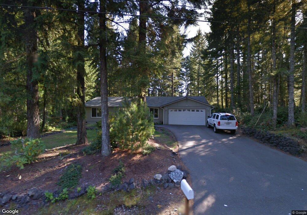
1620 E Saint Andrews Dr N Shelton, WA 98584
Estimated Value: $423,953 - $488,000
3
Beds
2
Baths
1,695
Sq Ft
$270/Sq Ft
Est. Value
About This Home
This home is located at 1620 E Saint Andrews Dr N, Shelton, WA 98584 and is currently estimated at $456,988, approximately $269 per square foot. 1620 E Saint Andrews Dr N is a home located in Mason County with nearby schools including Pioneer Primary School and Pioneer Intermediate/Middle School.
Ownership History
Date
Name
Owned For
Owner Type
Purchase Details
Closed on
Nov 3, 2005
Sold by
Bronson Bruce W and Bronson Linda M
Bought by
Wilsbach Joshua R and Wilsbach Latrisha F
Current Estimated Value
Home Financials for this Owner
Home Financials are based on the most recent Mortgage that was taken out on this home.
Original Mortgage
$44,000
Outstanding Balance
$14,821
Interest Rate
5.93%
Mortgage Type
Credit Line Revolving
Estimated Equity
$442,167
Create a Home Valuation Report for This Property
The Home Valuation Report is an in-depth analysis detailing your home's value as well as a comparison with similar homes in the area
Home Values in the Area
Average Home Value in this Area
Purchase History
| Date | Buyer | Sale Price | Title Company |
|---|---|---|---|
| Wilsbach Joshua R | $220,000 | Mason County Title Ins Co |
Source: Public Records
Mortgage History
| Date | Status | Borrower | Loan Amount |
|---|---|---|---|
| Open | Wilsbach Joshua R | $44,000 | |
| Open | Wilsbach Joshua R | $176,000 |
Source: Public Records
Tax History Compared to Growth
Tax History
| Year | Tax Paid | Tax Assessment Tax Assessment Total Assessment is a certain percentage of the fair market value that is determined by local assessors to be the total taxable value of land and additions on the property. | Land | Improvement |
|---|---|---|---|---|
| 2025 | $3,432 | $379,255 | $39,540 | $339,715 |
| 2024 | $3,432 | $430,900 | $38,360 | $392,540 |
| 2023 | $3,736 | $415,740 | $20,495 | $395,245 |
| 2022 | $3,146 | $318,890 | $22,035 | $296,855 |
| 2021 | $3,029 | $318,890 | $22,035 | $296,855 |
| 2020 | $2,740 | $282,805 | $18,365 | $264,440 |
| 2018 | $2,267 | $192,795 | $28,800 | $163,995 |
| 2017 | $1,920 | $192,795 | $28,800 | $163,995 |
| 2016 | $1,922 | $167,910 | $25,200 | $142,710 |
| 2015 | $1,656 | $167,910 | $25,200 | $142,710 |
| 2014 | -- | $159,960 | $24,000 | $135,960 |
| 2013 | -- | $143,140 | $24,000 | $119,140 |
Source: Public Records
Map
Nearby Homes
- 30 E Ballycastle Way
- 30 E Glenmorgan Ct
- 550 E Way To Tipperary St
- 321 E Ballycastle Way
- 1341 E Saint Andrews Dr N
- 151 E Galway Rd
- 110 E Shannon Place
- 1610 E Saint Andrews Dr N
- 120 E Shannon Place
- 51 E Glamis Ct
- 1091 E Saint Andrews Dr
- 0 XXX E Balmoral Way
- 90 E Blenheim Place
- 310 E Ballantrae Dr
- 161 E Connemara Way
- 271 E Ballantrae Dr
- 31 E Tintagel Place
- 101 E Paisley Way
- 280 E Clonakilty Dr
- 0 E Olde Lyme Rd
- 1590 E Saint Andrews Dr N
- 1650 E Saint Andrews Dr N
- 21 E Ballycastle Way
- 1580 E Saint Andrews Dr N
- 371 E Way To Tipperary St
- 361 E Way To Tipperary St
- 31 E Merioneth Rd
- 360 E Way To Tipperary St
- 1570 E Saint Andrews Dr N
- 1561 E Saint Andrews Dr N
- 391 E Way To Tipperary St
- 331 E Way To Tipperary St
- 41 E Merioneth Rd
- 20 E Merioneth Rd
- 411 E Way To Tipperary St
- 311 E Way To Tipperary St
- 30 E Merioneth Rd
- 1550 E Saint Andrews Dr N
- 1541 E Saint Andrews Dr N