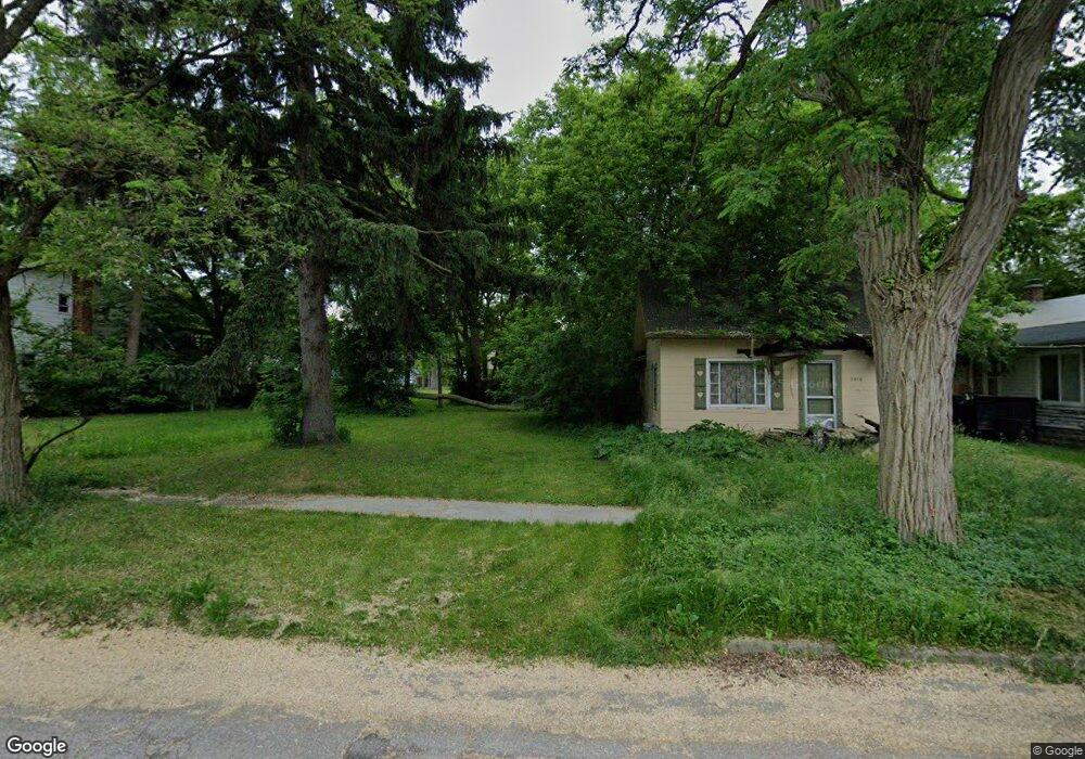
1620 Illinois Ave Flint, MI 48506
Eastside NeighborhoodEstimated Value: $27,000 - $56,000
2
Beds
1
Bath
600
Sq Ft
$69/Sq Ft
Est. Value
About This Home
This home is located at 1620 Illinois Ave, Flint, MI 48506 and is currently estimated at $41,333, approximately $68 per square foot. 1620 Illinois Ave is a home located in Genesee County with nearby schools including Doyle/Ryder School, Flint Cultural Center Academy, and WAY Academy of Flint.
Ownership History
Date
Name
Owned For
Owner Type
Purchase Details
Closed on
Feb 26, 2019
Sold by
Carrillo Carmen Jean
Bought by
Bruce Laron
Current Estimated Value
Purchase Details
Closed on
May 29, 2018
Sold by
Genesee County Land Bank Authority
Bought by
Myers Dan and Myers Maureen E
Purchase Details
Closed on
Dec 20, 2012
Sold by
Cherry Deborah L
Bought by
Genesee County Land Bank
Purchase Details
Closed on
Dec 7, 2006
Sold by
Mcguffin Donald R
Bought by
Critchley Martha
Purchase Details
Closed on
Oct 6, 1993
Sold by
Colwell Janeice M
Bought by
Mcguffin Donald R
Create a Home Valuation Report for This Property
The Home Valuation Report is an in-depth analysis detailing your home's value as well as a comparison with similar homes in the area
Home Values in the Area
Average Home Value in this Area
Purchase History
| Date | Buyer | Sale Price | Title Company |
|---|---|---|---|
| Bruce Laron | -- | None Available | |
| Myers Dan | -- | None Available | |
| Genesee County Land Bank | -- | None Available | |
| Critchley Martha | -- | None Available | |
| Mcguffin Donald R | $225 | None Available |
Source: Public Records
Tax History
| Year | Tax Paid | Tax Assessment Tax Assessment Total Assessment is a certain percentage of the fair market value that is determined by local assessors to be the total taxable value of land and additions on the property. | Land | Improvement |
|---|---|---|---|---|
| 2025 | $137 | $2,000 | $0 | $0 |
| 2024 | $128 | $2,000 | $0 | $0 |
| 2023 | $135 | $1,900 | $0 | $0 |
| 2022 | $0 | $1,900 | $0 | $0 |
| 2021 | $168 | $1,800 | $0 | $0 |
| 2020 | $158 | $1,500 | $0 | $0 |
| 2019 | $55 | $1,200 | $0 | $0 |
| 2018 | $0 | $0 | $0 | $0 |
| 2017 | $0 | $0 | $0 | $0 |
| 2016 | $0 | $0 | $0 | $0 |
| 2015 | -- | $0 | $0 | $0 |
| 2014 | -- | $0 | $0 | $0 |
| 2012 | -- | $6,000 | $0 | $0 |
Source: Public Records
Map
Nearby Homes
- 1609 Ohio Ave
- 1540 Illinois Ave
- 1724 Ohio Ave
- 1216 Minnesota Ave
- 1318 Cronk Ave
- 1529 Broadway Blvd
- 1501 Arlington Ave
- 1622 Arlington Ave
- 1379 Washington Ave
- 1805 Bennett Ave
- 2301 Missouri Ave
- 2302 Missouri Ave
- 2218 Kentucky Ave
- 1273 Broadway Blvd
- 1629 New York Ave
- 1721 New York Ave
- 2433 Pennsylvania Ave
- 2426 Broadway Blvd
- 1454 Delaware Ave
- 2506 Arlington Ave
- 1618 Illinois Ave
- 1614 Illinois Ave
- 1626 Illinois Ave
- 1630 Illinois Ave
- 1621 Wisconsin Ave
- 1625 Wisconsin Ave
- 1617 Wisconsin Ave
- 1610 Illinois Ave
- 1629 Wisconsin Ave
- 1634 Illinois Ave
- 1621 Illinois Ave
- 1638 Illinois Ave
- 1633 Wisconsin Ave
- 1613 Wisconsin Ave
- 1625 Illinois Ave
- 1617 Illinois Ave
- 1616 Iowa Ave
- 1629 Illinois Ave
- 1613 Illinois Ave
- 1606 Iowa Ave
Your Personal Tour Guide
Ask me questions while you tour the home.