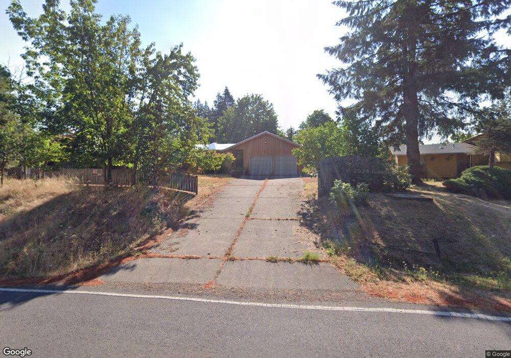
1620 Lorane Hwy Eugene, OR 97405
Crest Drive NeighborhoodEstimated Value: $447,000 - $552,000
3
Beds
2
Baths
1,584
Sq Ft
$323/Sq Ft
Est. Value
About This Home
This home is located at 1620 Lorane Hwy, Eugene, OR 97405 and is currently estimated at $511,454, approximately $322 per square foot. 1620 Lorane Hwy is a home located in Lane County with nearby schools including Adams Elementary School, Arts And Technology Academy At Jefferson, and Churchill High School.
Ownership History
Date
Name
Owned For
Owner Type
Purchase Details
Closed on
Oct 6, 2015
Sold by
Asman Janet
Bought by
Odlivak Victor
Current Estimated Value
Purchase Details
Closed on
Dec 2, 2008
Sold by
Dryness Kenneth W and Dyrness Dorothy Mae
Bought by
Dyrness Dorothy Mae and Dorothy Dyrness Family Trust
Purchase Details
Closed on
Apr 8, 2004
Sold by
Dyrness Dorothy Mae
Bought by
Dyrness Kenneth W and Dyrness Dorothy Mae
Create a Home Valuation Report for This Property
The Home Valuation Report is an in-depth analysis detailing your home's value as well as a comparison with similar homes in the area
Home Values in the Area
Average Home Value in this Area
Purchase History
We collect this data history from publicly available records. To have your information removed, we recommend requesting removal directly through your county’s website.
| Date | Buyer | Sale Price | Title Company |
|---|---|---|---|
| Odlivak Victor | $279,800 | Cascade Title Company | |
| Dyrness Dorothy Mae | -- | None Available | |
| Dyrness Kenneth W | -- | -- |
Source: Public Records
Tax History
| Year | Tax Paid | Tax Assessment Tax Assessment Total Assessment is a certain percentage of the fair market value that is determined by local assessors to be the total taxable value of land and additions on the property. | Land | Improvement |
|---|---|---|---|---|
| 2025 | $5,704 | $292,746 | -- | -- |
| 2024 | $5,633 | $284,220 | -- | -- |
| 2023 | $5,633 | $275,942 | $0 | $0 |
| 2022 | $5,277 | $267,905 | $0 | $0 |
| 2021 | $4,956 | $260,102 | $0 | $0 |
| 2020 | $4,892 | $252,527 | $0 | $0 |
| 2019 | $4,670 | $245,172 | $0 | $0 |
| 2018 | $4,346 | $231,099 | $0 | $0 |
| 2017 | $4,086 | $231,099 | $0 | $0 |
| 2016 | $3,966 | $224,368 | $0 | $0 |
| 2015 | $3,838 | $217,833 | $0 | $0 |
| 2014 | $3,752 | $211,488 | $0 | $0 |
Source: Public Records
Map
Nearby Homes
- 1355 Paige Ave
- 3021 Whitbeck Blvd
- 1151 Lorane Hwy
- 0 Mclean Blvd Unit 24671448
- 0 Mclean Blvd Unit 697374759
- 875 W 36th Ave
- 3210 Inspiration Point Dr
- 1783 Graham Dr
- 1 Storey Blvd
- 2 Storey Blvd
- 2985 Adams St
- 0 W 40th Ave Unit 3 639571582
- 3872 Monroe St
- 806 Sundance St
- 2030 W 34th Ave
- 2089 Graham Dr
- 605 Fulvue Dr
- 453 Dellwood Dr
- 2775 Fillmore St
- 3023 Ashley Loop
- 1506 Lorane Hwy
- 1630 Lorane Hwy
- 1485 Mesa Ave
- 1455 Mesa Ave
- 1497 Mesa Ave
- 1502 Lorane Hwy
- 1635 Lorane Hwy
- 1634 Lorane Hwy
- 1625 Lorane Hwy
- 1495 Hionda Ave
- 1470 Mesa Ave
- 1430 Mesa Ave
- 1435 Mesa Ave
- 1490 Mesa Ave
- 1499 Mesa Ave
- 1645 Lorane Hwy
- 1510 Em Ray Dr
- 1485 Kervon Ct
- 1498 Lorane Hwy
- 1445 Hionda Ave
Your Personal Tour Guide
Ask me questions while you tour the home.