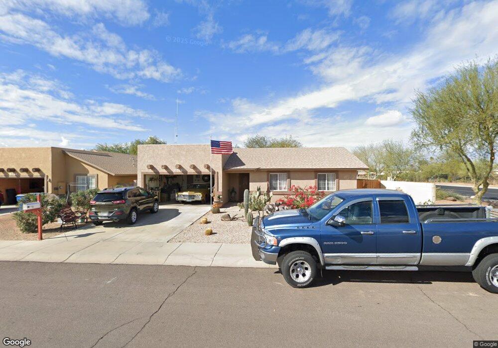
1620 S Stetson Ct Apache Junction, AZ 85119
Estimated Value: $338,000 - $359,731
3
Beds
2
Baths
1,302
Sq Ft
$270/Sq Ft
Est. Value
About This Home
This home is located at 1620 S Stetson Ct, Apache Junction, AZ 85119 and is currently estimated at $351,933, approximately $270 per square foot. 1620 S Stetson Ct is a home located in Pinal County with nearby schools including Peralta Trail Elementary School, Cactus Canyon Junior High School, and Apache Junction High School.
Ownership History
Date
Name
Owned For
Owner Type
Purchase Details
Closed on
Feb 25, 2010
Sold by
Secretary Of Housing & Urban Development
Bought by
Rygwalski Peter M and Rygwalski Lola
Current Estimated Value
Purchase Details
Closed on
May 28, 2009
Sold by
Moreno Victor and Moreno Bertha
Bought by
Wells Fargo Bank Na
Purchase Details
Closed on
Feb 14, 2008
Sold by
Moreno Victor and Hernandez Esteban
Bought by
Valdez Lavrientiev Caballero
Purchase Details
Closed on
Nov 2, 2004
Sold by
Nfn Enterprises Inc
Bought by
Moreno Victor and Moreno Bertha
Home Financials for this Owner
Home Financials are based on the most recent Mortgage that was taken out on this home.
Original Mortgage
$144,728
Interest Rate
5.7%
Mortgage Type
New Conventional
Create a Home Valuation Report for This Property
The Home Valuation Report is an in-depth analysis detailing your home's value as well as a comparison with similar homes in the area
Home Values in the Area
Average Home Value in this Area
Purchase History
| Date | Buyer | Sale Price | Title Company |
|---|---|---|---|
| Rygwalski Peter M | -- | Grand Canyon Title Agency | |
| Wells Fargo Bank Na | $147,086 | Great American Title Agency | |
| Secretary Of Housing & Urban Development | -- | Great American Title Agency | |
| Valdez Lavrientiev Caballero | -- | None Available | |
| Moreno Victor | $147,000 | First American Title Insuran |
Source: Public Records
Mortgage History
| Date | Status | Borrower | Loan Amount |
|---|---|---|---|
| Previous Owner | Moreno Victor | $144,728 |
Source: Public Records
Tax History
| Year | Tax Paid | Tax Assessment Tax Assessment Total Assessment is a certain percentage of the fair market value that is determined by local assessors to be the total taxable value of land and additions on the property. | Land | Improvement |
|---|---|---|---|---|
| 2025 | $1,270 | $31,790 | -- | -- |
| 2024 | $1,194 | $28,360 | -- | -- |
| 2023 | $1,250 | $21,520 | $1,100 | $20,420 |
| 2022 | $1,194 | $16,063 | $1,100 | $14,963 |
| 2021 | $1,232 | $14,359 | $0 | $0 |
| 2020 | $1,201 | $13,910 | $0 | $0 |
| 2019 | $1,149 | $13,175 | $0 | $0 |
| 2018 | $1,124 | $12,113 | $0 | $0 |
| 2017 | $1,096 | $11,369 | $0 | $0 |
| 2016 | $1,062 | $11,312 | $1,100 | $10,212 |
| 2014 | $1,020 | $6,685 | $1,100 | $5,585 |
Source: Public Records
Map
Nearby Homes
- 30 E 14th Ave
- 1363 W Chesapeake Dr
- 1358 W Kowa Cir Unit 358
- 1374 W Chesapeake Ave
- 1315 W Chesapeake Ave Unit 315
- 1880 S Coconino Dr
- 1328 W Inuit Ave
- 1431 S Apache Dr
- 1347 W Inuit Ave Unit 347
- 1340 W Inuit Ave
- 1336 W Inuit Ave Unit 336
- 1087 S Shoshone Dr
- 1135 S Sioux Dr
- 1357 S Kiowa Cir Unit 357
- 1001 Kiowa Cir
- 1177 Kiowa Cir Unit 177
- 1041 Cheyenne Dr Unit 41
- 1127 S Shawnee Dr
- 1448 S Zuni --
- 380 W 14th Ave
- 1632 S Stetson Ct
- 1660 S Stetson Ct
- 1544 S Stetson Rd
- 1644 S Stetson Ct
- 1578 S Stetson Rd
- 1672 S Stetson Ct
- 1656 S Stetson Ct
- 1667 S Stetson Ct
- 1684 S Stetson Ct
- 1679 S Stetson Ct
- 90 E 16th Ave
- 1689 S Stetson Ct
- 1521 S Idaho Rd
- 0000 W 16th Ave Unit A2
- 000 W 16th Ave Unit A2
- 142 E 16th Ave
- 231 E 16th Ave
- 1701 S Idaho Rd
- 0 E 18th Ave Unit 1535336
Your Personal Tour Guide
Ask me questions while you tour the home.