1620 W 1000 N Provo, UT 84604
Grandview South NeighborhoodEstimated payment $3,258/month
Highlights
- Mountain View
- Wood Flooring
- Hydromassage or Jetted Bathtub
- Rambler Architecture
- Main Floor Primary Bedroom
- Great Room
About This Home
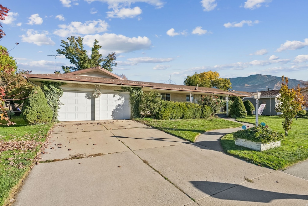
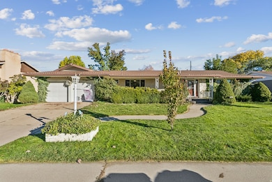
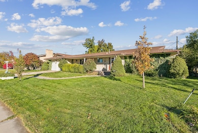
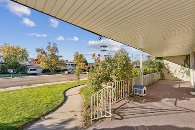
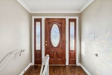
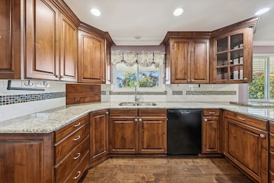
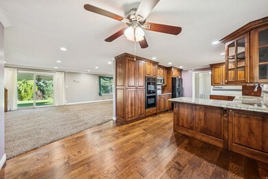
Nestled in the desirable Grandview Hill South neighborhood of Provo, this beautifully remodeled home blends modern elegance with everyday convenience. The main floor features recessed lighting, built-in surround sound, dedicated laundry, and abundant storage. The gourmet kitchen showcases granite countertops, tile backsplash, hardwood flooring, solid wood cabinetry with soft-close drawers, built-in pantry with pull-out shelves, and pocket doors for added privacy. Appliances include a matching black side-by-side refrigerator, dishwasher, built-in microwave, two convection ovens, and a new induction cooktop with five boost burners and child safety lock. Offering 3 spacious bedrooms plus a flexible 4th bedroom/office, the home includes 3 full bathrooms with tile floors, modern fixtures, and bidets, plus a convenient half bath near the garage. The primary suite provides a spa-like retreat with an oversized jetted tub, separate shower, and custom walk-in closet. Additional highlights include double-pane windows and doors, a solid wood front door with decorative glass, and extensive built-in storage throughout. The two-car garage offers dual doors, Wi-Fi smart openers, built-in cabinetry, workbench, and extra refrigerator/freezer. Mechanical upgrades include a new high-efficiency modulating furnace, variable-speed A/C, Wi-Fi thermostat, REME Halo air purifier, tankless water heater, and dual radon mitigation systems. Smart home features include a comprehensive Ring security system (indoor/outdoor cameras, motion sensors, keypad, and more) and 1GB Google Fiber internet. Set on a beautifully landscaped .23-acre lot, the home offers a long covered front porch, spacious covered back patio, fenced backyard with mature trees, lilac and rose bushes, ivy ground cover, Wi-Fi sprinkler system, and stunning mountain views. Square footage figures are provided as a courtesy estimate only and were obtained from county records . Buyer is advised to obtain an independent measurement.
Listing Agent
Kaden Wright
LPT REALTY, LLC License #12727350 Listed on: 10/30/2025
Home Details
Home Type
- Single Family
Est. Annual Taxes
- $2,733
Year Built
- Built in 1967
Lot Details
- 10,019 Sq Ft Lot
- Landscaped
- Sprinkler System
- Property is zoned Single-Family
Parking
- 2 Car Attached Garage
Home Design
- Rambler Architecture
- Brick Exterior Construction
Interior Spaces
- 3,074 Sq Ft Home
- 2-Story Property
- Ceiling Fan
- Recessed Lighting
- Self Contained Fireplace Unit Or Insert
- Includes Fireplace Accessories
- Double Pane Windows
- Blinds
- Sliding Doors
- Smart Doorbell
- Great Room
- Mountain Views
- Basement Fills Entire Space Under The House
- Electric Dryer Hookup
Kitchen
- Convection Oven
- Microwave
- Freezer
- Granite Countertops
- Disposal
- Instant Hot Water
Flooring
- Wood
- Carpet
- Tile
Bedrooms and Bathrooms
- 4 Bedrooms | 1 Primary Bedroom on Main
- Hydromassage or Jetted Bathtub
- Bathtub With Separate Shower Stall
Home Security
- Alarm System
- Smart Thermostat
- Storm Doors
Outdoor Features
- Covered Patio or Porch
Schools
- Westridge Elementary School
- Provo High School
Utilities
- Central Heating and Cooling System
- Natural Gas Connected
Community Details
- No Home Owners Association
- Provo Heights Subdivision
Listing and Financial Details
- Assessor Parcel Number 49-062-0018
Map
Home Values in the Area
Average Home Value in this Area
Tax History
| Year | Tax Paid | Tax Assessment Tax Assessment Total Assessment is a certain percentage of the fair market value that is determined by local assessors to be the total taxable value of land and additions on the property. | Land | Improvement |
|---|---|---|---|---|
| 2025 | $2,734 | $286,055 | $175,700 | $344,400 |
| 2024 | $2,734 | $269,115 | $0 | $0 |
| 2023 | $2,770 | $268,785 | $0 | $0 |
| 2022 | $2,695 | $263,670 | $0 | $0 |
| 2021 | $2,076 | $354,300 | $111,400 | $242,900 |
| 2020 | $2,001 | $320,100 | $101,300 | $218,800 |
| 2019 | $1,913 | $318,300 | $101,300 | $217,000 |
| 2018 | $1,676 | $282,800 | $94,100 | $188,700 |
| 2017 | $1,567 | $145,255 | $0 | $0 |
| 2016 | $1,582 | $136,730 | $0 | $0 |
| 2015 | $1,518 | $132,605 | $0 | $0 |
| 2014 | $1,256 | $114,400 | $0 | $0 |
Property History
| Date | Event | Price | List to Sale | Price per Sq Ft |
|---|---|---|---|---|
| 11/11/2025 11/11/25 | Price Changed | $575,000 | -4.2% | $187 / Sq Ft |
| 10/30/2025 10/30/25 | For Sale | $600,000 | -- | $195 / Sq Ft |
Purchase History
| Date | Type | Sale Price | Title Company |
|---|---|---|---|
| Warranty Deed | -- | Gt Title Services Slc | |
| Interfamily Deed Transfer | -- | None Available | |
| Warranty Deed | -- | Juab Title & Abstract Co |
Mortgage History
| Date | Status | Loan Amount | Loan Type |
|---|---|---|---|
| Open | $393,680 | VA | |
| Previous Owner | $30,499 | Credit Line Revolving | |
| Previous Owner | $162,650 | Fannie Mae Freddie Mac |
Source: UtahRealEstate.com
MLS Number: 2120358
APN: 49-062-0018
Disclaimer: Certain information contained herein is derived from information provided by parties other than Homes.com. All information provided is deemed reliable, but is not guaranteed to be accurate and should be independently verified.
![]() IDX information is provided exclusively for consumers’ personal, non-commercial use, that it may not be used for any purpose other than to identify prospective properties consumers may be interested in purchasing, and that the data is deemed reliable but is not guaranteed accurate by the MLS. Licensor is only providing the MLS Content and not other sources of data provided in the Product.
IDX information is provided exclusively for consumers’ personal, non-commercial use, that it may not be used for any purpose other than to identify prospective properties consumers may be interested in purchasing, and that the data is deemed reliable but is not guaranteed accurate by the MLS. Licensor is only providing the MLS Content and not other sources of data provided in the Product.
Based on information from the Wasatch Front Regional Multiple Listing Service, Inc.. All data, including all measurements and calculations of area, is obtained from various sources and has not been, and will not be, verified by broker or the MLS. All information should be independently reviewed and verified for accuracy. Properties may or may not be listed by the office/agent presenting the information.
- 932 N 1760 W
- 927 Independence Ave
- 1451 Arthur Dr
- 2043 W 1100 N
- 2075 W 1080 N
- 1127 Independence Ave
- 1471 W 1460 N
- 1375 W 1460 N
- 1188 W 1380 N
- 1503 N 1980 W
- 1250 Jordan Ave
- 1525 N 1250 W
- 1430 N 1160 W
- 1215 W 580 N
- 630 N 1100 W
- 1375 W 500 N Unit 95
- 1616 N 2100 W
- 1149 N 850 W
- 2397 W 1160 N
- 1500 Jordan Ave
- 1214 W 500 N
- 1287 Reese Dr
- 1227 Riverside Ave Unit 60
- 1245 Riverside Ave Unit 37
- 1710 Hickory Ln
- 810 N 600 W
- 556 W 800 N Unit Spacious Condo in Provo
- 1547 N Riverside Ave Unit 54-C
- 1541 N Riverside Ave Unit 15
- 160 N 800 W Unit Upstairs Unit
- 1851 S Columbia Ln
- 504 W 1720 N Unit 504
- 1757 Village Ln
- 449 W 1720 N
- 1733 S 750 E Unit 1731
- 1640 S State St Unit Executive Suite
- 1378 N Freedom Blvd
- 667 E 1650 S Unit Upstairs
- 538 N Freedom Blvd
- 480 N Freedom Blvd