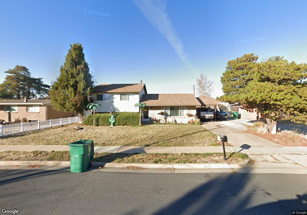
1620 W 1960 N Layton, UT 84041
Estimated Value: $387,000 - $424,000
3
Beds
2
Baths
1,690
Sq Ft
$243/Sq Ft
Est. Value
About This Home
This home is located at 1620 W 1960 N, Layton, UT 84041 and is currently estimated at $410,637, approximately $242 per square foot. 1620 W 1960 N is a home located in Davis County with nearby schools including Vae View Elementary School, North Layton Junior High School, and Northridge High School.
Ownership History
Date
Name
Owned For
Owner Type
Purchase Details
Closed on
Aug 27, 2021
Sold by
Padron Paulo
Bought by
Padron Paulo and Padron Leticia
Current Estimated Value
Purchase Details
Closed on
Sep 27, 2012
Sold by
Lee Gary B and Lee Loma M
Bought by
Padron Paulo
Home Financials for this Owner
Home Financials are based on the most recent Mortgage that was taken out on this home.
Original Mortgage
$137,464
Outstanding Balance
$94,805
Interest Rate
3.5%
Mortgage Type
FHA
Estimated Equity
$315,832
Create a Home Valuation Report for This Property
The Home Valuation Report is an in-depth analysis detailing your home's value as well as a comparison with similar homes in the area
Home Values in the Area
Average Home Value in this Area
Purchase History
| Date | Buyer | Sale Price | Title Company |
|---|---|---|---|
| Padron Paulo | -- | None Available | |
| Padron Paulo | -- | Security Title Of Davi |
Source: Public Records
Mortgage History
| Date | Status | Borrower | Loan Amount |
|---|---|---|---|
| Open | Padron Paulo | $137,464 |
Source: Public Records
Tax History Compared to Growth
Tax History
| Year | Tax Paid | Tax Assessment Tax Assessment Total Assessment is a certain percentage of the fair market value that is determined by local assessors to be the total taxable value of land and additions on the property. | Land | Improvement |
|---|---|---|---|---|
| 2025 | $1,834 | $192,500 | $107,896 | $84,604 |
| 2024 | $1,800 | $190,301 | $128,739 | $61,562 |
| 2023 | $1,733 | $323,000 | $165,008 | $157,992 |
| 2022 | $1,858 | $188,100 | $78,026 | $110,074 |
| 2021 | $1,762 | $266,000 | $111,933 | $154,067 |
| 2020 | $1,471 | $213,000 | $82,934 | $130,066 |
| 2019 | $1,466 | $208,000 | $79,746 | $128,254 |
| 2018 | $1,271 | $181,000 | $73,839 | $107,161 |
| 2016 | $1,099 | $80,740 | $20,971 | $59,769 |
| 2015 | $1,047 | $72,985 | $20,971 | $52,014 |
| 2014 | $1,116 | $79,550 | $20,971 | $58,579 |
| 2013 | -- | $70,567 | $18,612 | $51,955 |
Source: Public Records
Map
Nearby Homes
- 1606 W 1960 N
- 1900 N 1690 W
- 1748 N 1600 W
- 1740 N 1600 W Unit 116
- 1692 N 1600 W
- 1650 N Main St Unit 126
- 1688 N 1600 W Unit 125
- 1682 N 1600 W
- 1678 N 1600 W
- Highbridge 3 Plan at Layton Towns on Main - Townhomes
- Highbridge 1 Plan at Layton Towns on Main - Townhomes
- Midtown Plan at Layton Towns on Main - Townhomes
- Cityline 1 Plan at Layton Towns on Main - Townhomes
- Cityline 2 Plan at Layton Towns on Main - Townhomes
- 1668 N 1600 W
- 1664 N 1600 W
- 1596 N Main St Unit 2
- 1654 N 1600 W
- 1652 N 1600 St W
- 1598 N Main St