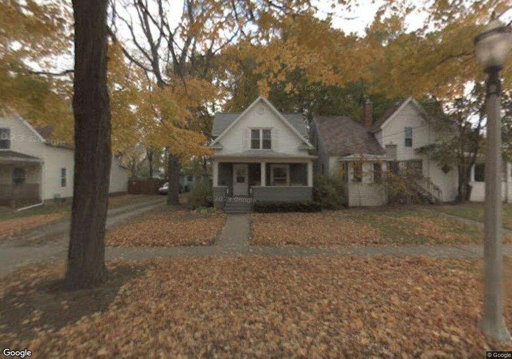
1621 Davis Ave Lansing, MI 48910
Moores Park NeighborhoodEstimated Value: $114,837 - $152,000
Studio
--
Bath
1,124
Sq Ft
$119/Sq Ft
Est. Value
About This Home
This home is located at 1621 Davis Ave, Lansing, MI 48910 and is currently estimated at $133,209, approximately $118 per square foot. 1621 Davis Ave is a home located in Ingham County with nearby schools including Averill Elementary School, Pattengill Academy, and J.W. Sexton High School.
Ownership History
Date
Name
Owned For
Owner Type
Purchase Details
Closed on
Jan 29, 2026
Sold by
Kapp Betty S and Betty S Kapp Revocable Trust
Bought by
Goucher Timothy Brian
Current Estimated Value
Purchase Details
Closed on
Nov 10, 2021
Sold by
Kapp Betty S
Bought by
Kapp Betty S and Betty S Kapp Revocable Trust N
Purchase Details
Closed on
Nov 24, 1997
Sold by
Cusmano Christine J
Bought by
Kapp Betty S
Purchase Details
Closed on
Oct 1, 1995
Create a Home Valuation Report for This Property
The Home Valuation Report is an in-depth analysis detailing your home's value as well as a comparison with similar homes in the area
Home Values in the Area
Average Home Value in this Area
Purchase History
| Date | Buyer | Sale Price | Title Company |
|---|---|---|---|
| Goucher Timothy Brian | -- | None Listed On Document | |
| Kapp Betty S | -- | None Available | |
| Kapp Betty S | $37,000 | -- | |
| -- | $41,900 | -- |
Source: Public Records
Tax History
| Year | Tax Paid | Tax Assessment Tax Assessment Total Assessment is a certain percentage of the fair market value that is determined by local assessors to be the total taxable value of land and additions on the property. | Land | Improvement |
|---|---|---|---|---|
| 2025 | $2,548 | $51,600 | $6,000 | $45,600 |
| 2024 | $20 | $52,900 | $6,000 | $46,900 |
| 2023 | $2,390 | $46,300 | $6,000 | $40,300 |
| 2022 | $2,156 | $44,000 | $8,500 | $35,500 |
| 2021 | $2,822 | $39,700 | $6,100 | $33,600 |
| 2020 | $2,801 | $38,200 | $6,100 | $32,100 |
| 2019 | $2,700 | $34,900 | $6,100 | $28,800 |
| 2018 | $2,565 | $33,300 | $6,100 | $27,200 |
| 2017 | $2,467 | $33,300 | $6,100 | $27,200 |
| 2016 | $2,369 | $32,800 | $6,100 | $26,700 |
| 2015 | $2,369 | $31,400 | $12,281 | $19,119 |
| 2014 | $2,369 | $30,300 | $6,942 | $23,358 |
Source: Public Records
Map
Nearby Homes
- 310 W Barnes Ave
- 205 Moores River Dr
- 227 Woodlawn Ave
- 139 Woodlawn Ave
- 202 Woodlawn Ave
- 1824 Davis Ave
- 1723 Osband Ave
- 1408 Reo Ave
- 1406 Reo Ave
- 612 W Mount Hope Ave
- 147 Isbell St
- 717 Smith Ave
- 1807 Teel Ave
- 1917 Teel Ave
- 712 Lenore Ave
- 315 E Mount Hope Ave
- 1400 Pico Ave
- 1017 W Barnes Ave
- 1839 Fletcher St
- 218 E Elm St
- 1617 Davis Ave
- 326 W Barnes Ave
- 312 W Barnes Ave
- 312 -314 W Barnes Ave
- 1609 Davis Ave
- 312 W Barnes Ave
- 323 Moores River Dr
- 327 Moores River Dr
- 304 W Barnes Ave
- 319 Moores River Dr
- 400 W Barnes Ave
- 1616 Todd Ave
- 1610 Todd Ave
- 1620 Davis Ave
- 315 Moores River Dr
- 1616 Davis Ave
- 1610 Davis Ave
- 300 W Barnes Ave
- 311 Moores River Dr
- 325 W Barnes Ave