Estimated Value: $161,000 - $190,302
3
Beds
2
Baths
1,141
Sq Ft
$152/Sq Ft
Est. Value
About This Home
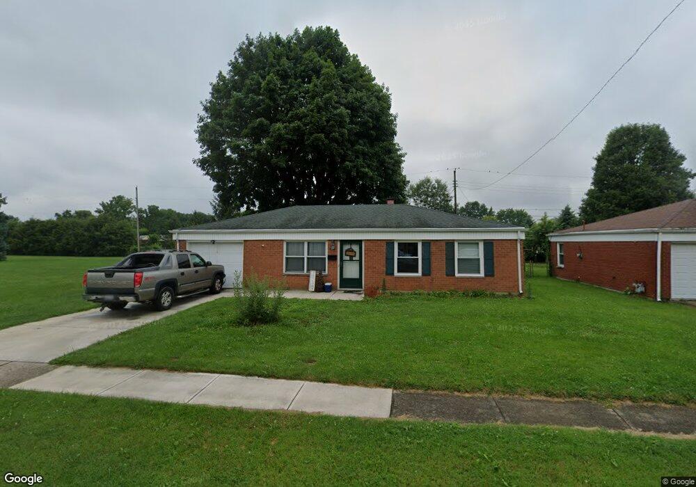
This home is located at 1621 Reid Ave, Xenia, OH 45385 and is currently estimated at $173,326, approximately $151 per square foot. 1621 Reid Ave is a home located in Greene County with nearby schools including Xenia High School, Summit Academy Community School for Alternative Learners - Xenia, and Legacy Christian Academy.
Ownership History
Date
Name
Owned For
Owner Type
Purchase Details
Closed on
Feb 21, 2025
Sold by
Combs Lloyd Stephen and Combs Stephen L
Bought by
Belcher Brenda K
Current Estimated Value
Home Financials for this Owner
Home Financials are based on the most recent Mortgage that was taken out on this home.
Original Mortgage
$173,000
Outstanding Balance
$171,897
Interest Rate
7.25%
Mortgage Type
New Conventional
Estimated Equity
$1,429
Purchase Details
Closed on
Feb 4, 2025
Sold by
Combs Sheri D
Bought by
Combs L Stephen
Home Financials for this Owner
Home Financials are based on the most recent Mortgage that was taken out on this home.
Original Mortgage
$173,000
Outstanding Balance
$171,897
Interest Rate
7.25%
Mortgage Type
New Conventional
Estimated Equity
$1,429
Purchase Details
Closed on
Oct 25, 2021
Sold by
Miller Dennis E and Miller Monna L
Bought by
Combs L Stephen L and Combs Shed D
Create a Home Valuation Report for This Property
The Home Valuation Report is an in-depth analysis detailing your home's value as well as a comparison with similar homes in the area
Home Values in the Area
Average Home Value in this Area
Purchase History
| Date | Buyer | Sale Price | Title Company |
|---|---|---|---|
| Belcher Brenda K | $169,000 | Home Services Title | |
| Combs L Stephen | -- | Home Services Title | |
| Combs L Stephen L | $97,500 | None Available |
Source: Public Records
Mortgage History
| Date | Status | Borrower | Loan Amount |
|---|---|---|---|
| Open | Belcher Brenda K | $173,000 |
Source: Public Records
Tax History Compared to Growth
Tax History
| Year | Tax Paid | Tax Assessment Tax Assessment Total Assessment is a certain percentage of the fair market value that is determined by local assessors to be the total taxable value of land and additions on the property. | Land | Improvement |
|---|---|---|---|---|
| 2024 | $2,093 | $48,920 | $10,000 | $38,920 |
| 2023 | $2,093 | $48,920 | $10,000 | $38,920 |
| 2022 | $1,708 | $34,050 | $7,140 | $26,910 |
| 2021 | $1,731 | $34,050 | $7,140 | $26,910 |
| 2020 | $1,659 | $34,050 | $7,140 | $26,910 |
| 2019 | $1,281 | $24,760 | $4,810 | $19,950 |
| 2018 | $1,286 | $24,760 | $4,810 | $19,950 |
| 2017 | $1,208 | $24,760 | $4,810 | $19,950 |
| 2016 | $1,208 | $22,820 | $4,810 | $18,010 |
| 2015 | $1,211 | $22,820 | $4,810 | $18,010 |
| 2014 | $1,160 | $22,820 | $4,810 | $18,010 |
Source: Public Records
Map
Nearby Homes
- 1391 June Dr
- 1283 June Dr
- 121 S Progress Dr
- 1351 Omard Dr
- 1233 June Dr
- 1223 June Dr
- 1342 Kylemore Dr
- 343 Sheelin Rd
- 1144 Rockwell Dr
- 1568 Cheyenne Dr
- 912 Omard Dr
- 883 Omard Dr
- 509 Antrim Rd
- 1618 Navajo Dr
- 1653 Seneca Dr
- 161 Montana Dr
- 2758 Wyoming Dr
- 1208 Bellbrook Ave
- 1272 Bellbrook Ave
- 219 Kansas Dr