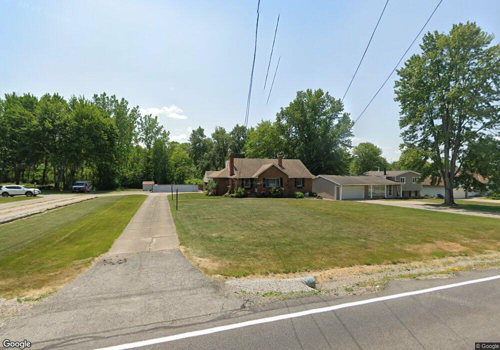
16221 Whitney Rd Strongsville, OH 44136
Estimated Value: $320,000 - $379,000
4
Beds
2
Baths
2,211
Sq Ft
$154/Sq Ft
Est. Value
About This Home
This home is located at 16221 Whitney Rd, Strongsville, OH 44136 and is currently estimated at $341,476, approximately $154 per square foot. 16221 Whitney Rd is a home located in Cuyahoga County with nearby schools including Strongsville High School, Sts Joseph & John Interparochial School, and The Academy of St. Bartholomew.
Ownership History
Date
Name
Owned For
Owner Type
Purchase Details
Closed on
Jan 14, 2002
Sold by
Coleff Nola L and Coleff Keith E
Bought by
Coleff Keith E and Coleff Nola L
Current Estimated Value
Home Financials for this Owner
Home Financials are based on the most recent Mortgage that was taken out on this home.
Original Mortgage
$30,924
Interest Rate
6.69%
Purchase Details
Closed on
Oct 13, 2000
Sold by
Cliford Donald C and Clifford Nola M
Bought by
Coleff Nola L
Home Financials for this Owner
Home Financials are based on the most recent Mortgage that was taken out on this home.
Original Mortgage
$175,000
Outstanding Balance
$64,322
Interest Rate
8.03%
Estimated Equity
$277,154
Purchase Details
Closed on
Feb 20, 1991
Sold by
Clifford Donald C and Clifford Nola M
Bought by
Clifford Nola M
Purchase Details
Closed on
Jan 1, 1982
Bought by
Clifford Donald C and Clifford Nola M
Create a Home Valuation Report for This Property
The Home Valuation Report is an in-depth analysis detailing your home's value as well as a comparison with similar homes in the area
Home Values in the Area
Average Home Value in this Area
Purchase History
| Date | Buyer | Sale Price | Title Company |
|---|---|---|---|
| Coleff Keith E | -- | -- | |
| Coleff Nola L | $184,000 | Majestic Title Agency Llc | |
| Clifford Nola M | -- | -- | |
| Clifford Donald C | -- | -- |
Source: Public Records
Mortgage History
| Date | Status | Borrower | Loan Amount |
|---|---|---|---|
| Closed | Coleff Keith E | $30,924 | |
| Open | Coleff Nola L | $175,000 |
Source: Public Records
Tax History Compared to Growth
Tax History
| Year | Tax Paid | Tax Assessment Tax Assessment Total Assessment is a certain percentage of the fair market value that is determined by local assessors to be the total taxable value of land and additions on the property. | Land | Improvement |
|---|---|---|---|---|
| 2024 | $4,602 | $98,000 | $14,875 | $83,125 |
| 2023 | $4,776 | $76,270 | $19,990 | $56,280 |
| 2022 | $4,741 | $76,270 | $19,990 | $56,280 |
| 2021 | $4,704 | $76,270 | $19,990 | $56,280 |
| 2020 | $4,468 | $64,090 | $16,800 | $47,290 |
| 2019 | $4,337 | $183,100 | $48,000 | $135,100 |
| 2018 | $3,965 | $64,090 | $16,800 | $47,290 |
| 2017 | $4,068 | $61,320 | $13,230 | $48,090 |
| 2016 | $4,035 | $61,320 | $13,230 | $48,090 |
| 2015 | $3,973 | $61,320 | $13,230 | $48,090 |
| 2014 | $3,973 | $59,540 | $12,850 | $46,690 |
Source: Public Records
Map
Nearby Homes
- 9129 Tahoe Cir
- 9945 Twelve Oaks Cir
- 10369 Council Bluff
- 9890 Webster Rd
- 10010 Chevy Chase
- 18203 Broxton Dr
- 18433 Whitney Rd
- 15485 Albion Rd
- 9531 Nicole Cir
- 16519 Albion Rd
- 0 Webster Rd
- 18737 Evergreen Dr
- 7685 Saratoga Rd
- 14015 Byron Blvd
- 13976 W Sprague Rd
- Buchanan Plan at The Enclave at Pine Lakes Crossing
- Belleville Plan at The Enclave at Pine Lakes Crossing
- 14069 Basswood Cir
- 7475 Lanier Dr
- 16347 Craigmere Dr
- 16273 Whitney Rd
- 16171 Whitney Rd
- 16319 Whitney Rd
- 16125 Whitney Rd
- 16363 Whitney Rd
- 16264 Whitney Rd
- 16216 Whitney Rd
- 16340 Commons Oval
- 16350 Commons Oval
- 16350 Commons Oval Unit 7
- 16360 Commons Oval
- 16075 Whitney Rd
- 16290 Commons Oval
- 16314 16316 Whitney Rd
- 16316 Whitney Rd
- 16380 Commons Oval
- 16314 Whitney Rd
- 16409 Whitney Rd
- 16280 Commons Oval
- 16390 Commons Oval